Country:
 USA
USARegion:
City:
Latitude and Longitude:
Time Zone:
Postal Code:
IP information under different IP Channel
ip-api
Country
Region
City
ASN
Time Zone
ISP
Blacklist
Proxy
Latitude
Longitude
Postal
Route
IPinfo
Country
Region
City
ASN
Time Zone
ISP
Blacklist
Proxy
Latitude
Longitude
Postal
Route
MaxMind
Country
Region
City
ASN
Time Zone
ISP
Blacklist
Proxy
Latitude
Longitude
Postal
Route
Luminati
Country
USRegion
ca
City
santamonica
ASN
Time Zone
America/Los_Angeles
ISP
TWC-20001-PACWEST
Latitude
Longitude
Postal
db-ip
Country
Region
City
ASN
Time Zone
ISP
Blacklist
Proxy
Latitude
Longitude
Postal
Route
ipdata
Country
Region
City
ASN
Time Zone
ISP
Blacklist
Proxy
Latitude
Longitude
Postal
Route
Popular places and events near this IP address
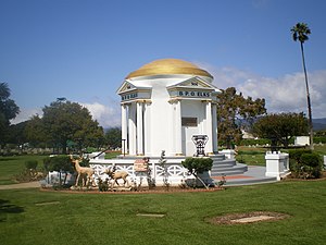
Woodlawn Memorial Cemetery (Santa Monica, California)
Cemetery in Santa Monica, California
Distance: Approx. 839 meters
Latitude and longitude: 34.0175,-118.475
Woodlawn Cemetery, Mausoleum & Mortuary, formerly Ballona Cemetery, is located at 1847 14th Street, alongside Pico Boulevard in Santa Monica, California, United States. The cemetery was founded in 1897 and sits on 26 acres. It is owned and operated by the city of Santa Monica and is the final resting place of more than 54,000 people.

Crossroads School (Santa Monica, California)
School in Santa Monica, California, United States
Distance: Approx. 1430 meters
Latitude and longitude: 34.02444444,-118.47388889
Crossroads School for Arts & Sciences is a private/independent, college preparatory school in Santa Monica, California, United States. The school is a former member of the G20 Schools Group.
Santa Monica College
Community college in Santa Monica, California
Distance: Approx. 531 meters
Latitude and longitude: 34.0168,-118.4707
Santa Monica College (SMC) is a public community college in Santa Monica, California. Founded as a junior college in 1929, SMC enrolls over 30,000 students in more than 90 fields of study. The college initially served pre-college high school students, eventually expanding its enrollment to educate college-age and non-traditional students with the intention to transfer to a four-year university.

Santa Monica High School
Public school in California, United States
Distance: Approx. 1553 meters
Latitude and longitude: 34.0116,-118.485
Santa Monica High School, officially abbreviated to Samohi, is a public high school in Santa Monica, California. Founded in 1891, it changed location several times in its early years before settling into its present campus at 601 Pico Boulevard. It is a part of the Santa Monica–Malibu Unified School District.
Santa Monica–Malibu Unified School District
School district in Santa Monica, California, US
Distance: Approx. 1464 meters
Latitude and longitude: 34.02222222,-118.47888889
Santa Monica–Malibu Unified School District (SMMUSD) is a school district located in Santa Monica, California. The district serves the cities of Santa Monica and Malibu. It has ten elementary schools, two middle schools, three high schools, an adult high school, and an alternative school.

Santa Monica Alternative School House
Primary school in Santa Monica, California, United States
Distance: Approx. 1452 meters
Latitude and longitude: 34.005183,-118.481227
The Santa Monica Alternative School House (SMASH) is an alternative school in Southern California that was founded in 1973 to emphasize "non-authoritarian, non-competitive, non-sexist methods". Originally serving grades Kindergarten through 12th, SMASH downgraded to a Kindergarten through middle school curriculum in the late 1980s. In 2005–2006, SMASH had 193 students enrolled in grades K-8.
Armet Davis Newlove Architects
Architectural firm in Santa Monica, California, USA
Distance: Approx. 1376 meters
Latitude and longitude: 34.0192983,-118.4806483
Armet Davis Newlove Architects, formerly Armét & Davis, is a Californian architectural firm known for working in the Googie architecture style that marks many distinctive coffee shops and eateries in Southern California. The firm designed Pann's, the first Norms Restaurants location, the Holiday Bowl and many other iconic locations.

Lincoln Place Apartment Homes
United States historic place
Distance: Approx. 1478 meters
Latitude and longitude: 34.001364,-118.459479
Lincoln Place Apartment Homes is a historic apartment community owned by a subsidiary of Apartment Investment and Management Co. (Aimco). Inspired by the garden city movement, it is located at 1050 Frederick Street on a 35-acre site in the Venice community of Los Angeles, one mile east of Venice Beach.
Electronic Café International
Performance space in Santa Monica, California, USA
Distance: Approx. 1542 meters
Latitude and longitude: 34.023893,-118.477713
Electronic Café International (ECI), established in 1988 by Kit Galloway and Sherrie Rabinowitz, is a performance space and real café housed in the 18th Street Arts Center in Santa Monica, California.
18th Street Arts Center
Arts center in Santa Monica, California, United States
Distance: Approx. 1552 meters
Latitude and longitude: 34.024157,-118.477424
18th Street Arts Center is a nonprofit arts center in Santa Monica, California. It was founded in 1988 and is the longest running artist residency center in Southern California. 18th Street Arts Center’s residency program hosts 60 or more American and international artists and curators a year.

Corsair Field
Stadium in Santa Monica, California, US
Distance: Approx. 445 meters
Latitude and longitude: 34.01527778,-118.47166667
Corsair Field is an artificial turf stadium in the main campus of Santa Monica College.

Virginia Avenue Park
Park in Santa Monica, California, United States
Distance: Approx. 990 meters
Latitude and longitude: 34.02138889,-118.46777778
Virginia Avenue Park is a 9.5 acres (3.8 ha) park located in the Pico neighborhood of Santa Monica, California. Originally opened in 1976, the park was redeveloped and expanded in the 1990s and early 2000s, reopening in 2005. The park hosts a number of community activities such as a weekly farmers market, afterschool programs, and social program assistance.
Weather in this IP's area
broken clouds
32 Celsius
36 Celsius
25 Celsius
37 Celsius
1011 hPa
57 %
1011 hPa
1006 hPa
4265 meters
1.79 m/s
3.58 m/s
236 degree
56 %
06:53:02
18:29:43