Country:
Region:
City:
Latitude and Longitude:
Time Zone:
Postal Code:
IP information under different IP Channel
ip-api
Country
Region
City
ASN
Time Zone
ISP
Blacklist
Proxy
Latitude
Longitude
Postal
Route
IPinfo
Country
Region
City
ASN
Time Zone
ISP
Blacklist
Proxy
Latitude
Longitude
Postal
Route
MaxMind
Country
Region
City
ASN
Time Zone
ISP
Blacklist
Proxy
Latitude
Longitude
Postal
Route
Luminati
Country
Region
qc
City
huntingdon
ASN
Time Zone
America/Toronto
ISP
CC-3272
Latitude
Longitude
Postal
db-ip
Country
Region
City
ASN
Time Zone
ISP
Blacklist
Proxy
Latitude
Longitude
Postal
Route
ipdata
Country
Region
City
ASN
Time Zone
ISP
Blacklist
Proxy
Latitude
Longitude
Postal
Route
Popular places and events near this IP address

Le Haut-Saint-Laurent Regional County Municipality
Regional county municipality in Quebec, Canada
Distance: Approx. 1738 meters
Latitude and longitude: 45.08,-74.17
Le Haut-Saint-Laurent (Upper Saint Lawrence) is a regional county municipality in southwestern Quebec, Canada, in the Montérégie region. Its seat is in Huntingdon. It is named for the Saint Lawrence River, which forms its western and its northwestern boundaries.

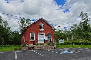
Huntingdon, Quebec
Town in Quebec, Canada
Distance: Approx. 1738 meters
Latitude and longitude: 45.08,-74.17
Huntingdon is a small town in Huntingdon County in the Haut-Saint-Laurent Regional County Municipality, and the Montérégie region of the province of Quebec, Canada. The population as of the 2021 Canadian census was 2,556. The town is 75 kilometres (47 mi) southwest of Montreal, and 15 kilometres (9.3 mi) from the border with New York State.
Huntingdon (federal electoral district)
Federal electoral district in Quebec, Canada
Distance: Approx. 2062 meters
Latitude and longitude: 45.077,-74.174
Huntingdon was a federal electoral district in Quebec, Canada, that was represented in the House of Commons of Canada from 1867 to 1917. It was created by the British North America Act, 1867. It was amalgamated into the Châteauguay—Huntingdon electoral district in 1914.

Elgin, Quebec
Municipality in Quebec, Canada
Distance: Approx. 9291 meters
Latitude and longitude: 45.0222,-74.2292
Elgin is a rural municipality in Quebec, Canada. The population as of the 2021 Canadian census was 389. It is located southwest of Huntingdon and bounded by the Trout and Châteauguay rivers and the Canada–United States border.
Hinchinbrooke, Quebec
Municipality in Quebec, Canada
Distance: Approx. 7637 meters
Latitude and longitude: 45.05,-74.1
Hinchinbrooke (or Hinchinbrook until 1993) is a rural community in southern Quebec, Canada, in the Châteauguay Valley, in the MRC de Le Haut-Saint-Laurent. The population as of the 2021 Canadian census was 2,187.
Dewittville
Unincorporated community in Quebec, Canada
Distance: Approx. 6443 meters
Latitude and longitude: 45.114,-74.095
Dewittville is a small community situated on the Châteauguay River in southern Quebec, Canada, between the towns of Huntingdon and Ormstown, approximately 70 km south-west of Montreal. In 1829, Jacob De Witt acquired a sawmill and 130 acres (53 ha) of land at Portage, which was later renamed to Dewittville. The old grist mill, dam, and Châteauguay River are notable attractions.
Godmanchester, Quebec
Township municipality in Quebec, Canada
Distance: Approx. 6316 meters
Latitude and longitude: 45.08,-74.25
Godmanchester is a township municipality located in Le Haut-Saint-Laurent Regional County Municipality in the Montérégie region of Quebec, Canada. The population as of the 2021 Canadian census was 1,403 The southeast part of the township is mostly delineated by the Châteauguay River, while the south end borders with Franklin County, New York. It was named after Godmanchester, England, in 1811.
Sainte-Barbe, Quebec
Municipality in Quebec, Canada
Distance: Approx. 8207 meters
Latitude and longitude: 45.16666667,-74.2
Sainte-Barbe is a municipality of Quebec, located within Le Haut-Saint-Laurent Regional County Municipality in the Montérégie administrative region. The population as of the Canada 2021 Census was 1,609.
Boisé-des-Muir Ecological Reserve
Ecological reserve in Canada
Distance: Approx. 4562 meters
Latitude and longitude: 45.0847,-74.1167
Boisé-des-Muir Ecological Reserve is an ecological reserve of Quebec, Canada. It was established in 1995.

Powerscourt Covered Bridge
Covered bridge in southern Quebec, Canada
Distance: Approx. 9717 meters
Latitude and longitude: 45.00871,-74.15953
The Powerscourt Covered Bridge is a covered bridge that takes the First Concession Road across the Châteauguay River in Hinchinbrooke, Quebec. It is also known as the Percy Bridge. It was constructed in 1861, and employs the McCallum inflexible arched truss, developed by Daniel McCallum.
Trout River (Chateauguay River tributary)
River in United States, Canada
Distance: Approx. 1163 meters
Latitude and longitude: 45.09,-74.18527778
Trout River (French: Rivière Trout) is a tributary of Châteauguay River, flowing in: the Adirondack Park, in Franklin County, New York, in Northern of New York State, in United States; the municipalities of Godmanchester and Elgin, in the Le Haut-Saint-Laurent Regional County Municipality, in the administrative region of Montérégie, in southwestern Quebec, Canada. This valley is mainly served in Quebec by the route 138 which passes on the west side of the river (from the border), then on the northwest side going towards the mouth. In New York State, the nearby route is Constable Street and State Highway 30.

Coaticook River
River in the United States and Canada
Distance: Approx. 1163 meters
Latitude and longitude: 45.09,-74.18527778
The Coaticook River is a north-flowing river rising in Vermont, United States, and located primarily in the Estrie region of Quebec, Canada. The mouth of the river is located north of Waterville and south of Lennoxville, near the southern border of the city of Sherbrooke, at the Massawippi River. Via the Massawippi and the Saint-François River, it is part of the St.
Weather in this IP's area
clear sky
10 Celsius
8 Celsius
6 Celsius
10 Celsius
1033 hPa
63 %
1033 hPa
1027 hPa
10000 meters
2.92 m/s
3.69 m/s
209 degree
07:16:51
18:06:18


