Country:
 Canada
Region:
City:
Latitude and Longitude:
Time Zone:
Postal Code:
IP information under different IP Channel
ip-api
Country
Region
City
ASN
Time Zone
ISP
Blacklist
Proxy
Latitude
Longitude
Postal
Route
IPinfo
Country
Region
City
ASN
Time Zone
ISP
Blacklist
Proxy
Latitude
Longitude
Postal
Route
MaxMind
Country
Region
City
ASN
Time Zone
ISP
Blacklist
Proxy
Latitude
Longitude
Postal
Route
Luminati
Country
CARegion
qc
City
saintsauveur
ASN
Time Zone
America/Toronto
ISP
CC-3272
Latitude
Longitude
Postal
db-ip
Country
Region
City
ASN
Time Zone
ISP
Blacklist
Proxy
Latitude
Longitude
Postal
Route
ipdata
Country
Region
City
ASN
Time Zone
ISP
Blacklist
Proxy
Latitude
Longitude
Postal
Route
Popular places and events near this IP address

Les Pays-d'en-Haut Regional County Municipality
Regional county municipality in Quebec, Canada
Distance: Approx. 7557 meters
Latitude and longitude: 45.95,-74.13333333
Les Pays-d'En-Haut (French pronunciation: [le pɛi dɑ̃ o]) is a regional county municipality in the Laurentides region of Quebec, Canada. The population according to the 2016 Canadian Census was 41,877.

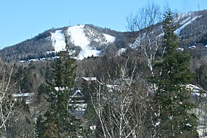
Morin-Heights
Municipality in Quebec, Canada
Distance: Approx. 5435 meters
Latitude and longitude: 45.9,-74.25
Morin-Heights is a town in the Laurentian Mountains region of Quebec, Canada. It is west of Saint-Sauveur and north of Lachute; municipally, it is within the Regional County Municipality of Les Pays-d'en-Haut. It is primarily a tourist town, having a large ski hill (Ski Morin Heights) that is popular during the winter months and being on a recreational trailway (the Aerobic Corridor), which is used year-round.

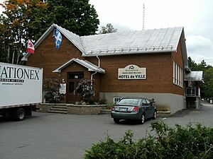
Saint-Sauveur, Quebec
City in Quebec, Canada
Distance: Approx. 1337 meters
Latitude and longitude: 45.9,-74.17
Saint-Sauveur (French pronunciation: [sɛ̃ sovœʁ]) is a town and municipality within the Les Pays-d'en-Haut Regional County Municipality, Quebec, Canada. It is in the administrative region of Laurentides in the Laurentian mountains, located about 60 kilometres north of Montreal. St-Sauveur is well known for its local ski areas, the biggest of which is Mont Saint-Sauveur.

Le Studio
Former recording studio in Morin-Heights, Quebec
Distance: Approx. 7068 meters
Latitude and longitude: 45.876137,-74.269848
Le Studio (later renamed Studio Morin Heights) was a residential recording studio in the Laurentian Mountains near the town of Morin-Heights, Quebec, Canada. Built in 1972 by recording engineer and producer André Perry, along with his wife Yaël Brandeis and Nick Blagona, the studio was seen as one of the top recording venues in North America during its existence, renowned for its retreat-like location and state-of-the-art equipment. Numerous notable Canadian and international artists recorded and stayed at Le Studio, including Rush (most notably), The Police, David Bowie, the Bee Gees, Cat Stevens, April Wine, Nazareth, Queensrÿche, and Celine Dion.
Sainte-Anne-des-Lacs
Parish municipality in Quebec, Canada
Distance: Approx. 5860 meters
Latitude and longitude: 45.85,-74.13333333
Sainte-Anne-des-Lacs is a municipality in the regional county municipality of Les Pays-d'en-Haut in Quebec, Canada, located in the administrative region of Laurentides. The municipality was founded in 1946 and was assigned the municipal number 77035 by the Quebec government. The Roman Catholic parish of Sainte-Anne-des-Lacs was founded in 1940.

Prévost, Quebec
City in Quebec, Canada
Distance: Approx. 8170 meters
Latitude and longitude: 45.87,-74.08
Prévost is a town within the La Rivière-du-Nord Regional County Municipality, Quebec, Canada, and the administrative region of Laurentides in the Laurentian Mountains, north of Montreal. It was created in 1973 from the amalgamation of the former villages of Shawbridge and Lesage with old Prévost on the other side of the Rivière du Nord. Shawbridge was named after William Shaw (1805-1894) who settled in the township of Abercromby in 1847 and built the first bridge over the Rivière du Nord.

Piedmont, Quebec
Municipality in Quebec, Canada
Distance: Approx. 4089 meters
Latitude and longitude: 45.9,-74.13
Piedmont is a small municipality within the Les Pays-d'en-Haut Regional County Municipality, Quebec, Canada, in the Laurentian Mountains of the administrative region of Laurentides. It is located along the North River and Autoroute 15 and Route 117, north of Montreal. Police services are provided by the Régie intermunicipale de police de la Rivière-du-Nord, which also serves Prévost and some other nearby communities in the Laurentians.
Rivière-du-Nord Intermunicipal Police Board
Canadian intermunicipal policing board
Distance: Approx. 8092 meters
Latitude and longitude: 45.8743,-74.0794
The Régie intermunicipale de police de la Rivière-du-Nord (French for Rivière-du-Nord Intermunicipal Police Board) was the shared police service of three (originally four) municipalities in Quebec's Laurentians: Saint-Hippolyte Piedmont Sainte-Anne-des-Lacs Prévost was originally part of the police service, but left it on April 1, 2004, however the police service's headquarters remained in Prévost. In May 2009 plans were revealed to close the service and turn policing of the remaining three municipalities over to the Sûreté du Québec. On October 23, 2009, the Régie intermunicipale de police de la Rivière-du-Nord's policing operations ended at 1 minute past midnight.

Sainte-Adèle
City in Quebec, Canada
Distance: Approx. 7687 meters
Latitude and longitude: 45.95,-74.13
Sainte-Adèle (French pronunciation: [sɛ̃t adɛl]) is a municipality in Quebec, Canada, and is part of the Les Pays-d'en-Haut Regional County Municipality. It lies on Route 117 about 70 kilometres (43 mi) north-west of Montreal. Its tourism-based economy centres on its skiing and hotel industry.
Lake Guindon
Distance: Approx. 5742 meters
Latitude and longitude: 45.8675,-74.115
Lake Guindon is the name of a lake in Sainte-Anne-des-Lacs, Quebec. It is also the name of the community near the lake, and the former name of a post office there, which was subsequently renamed Sainte-Anne-des-Lacs.
Mont Olympia
Distance: Approx. 5140 meters
Latitude and longitude: 45.9142,-74.1239
Sommet Olympia is a ski school and resort in Quebec, Canada. The resort is located not far from Montreal, in the Laurentians. According to ski express magazine, Mont Olympia is "the best" ski mountain for beginners.
Ski Chantecler
Distance: Approx. 7853 meters
Latitude and longitude: 45.96111111,-74.17277778
Ski Chantecler is a ski resort in the Laurentides region of the Canadian province of Quebec, Canada. It is a few minutes away from the town of Sainte-Adèle and one hour north from Montreal. 25 trails are available to ski.
Weather in this IP's area
clear sky
10 Celsius
9 Celsius
8 Celsius
10 Celsius
1032 hPa
58 %
1032 hPa
997 hPa
10000 meters
2.01 m/s
2.06 m/s
269 degree
07:17:57
18:05:16