Country:
 USA
USARegion:
City:
Latitude and Longitude:
Time Zone:
Postal Code:
IP information under different IP Channel
ip-api
Country
Region
City
ASN
Time Zone
ISP
Blacklist
Proxy
Latitude
Longitude
Postal
Route
IPinfo
Country
Region
City
ASN
Time Zone
ISP
Blacklist
Proxy
Latitude
Longitude
Postal
Route
MaxMind
Country
Region
City
ASN
Time Zone
ISP
Blacklist
Proxy
Latitude
Longitude
Postal
Route
Luminati
Country
USRegion
ne
City
kearney
ASN
Time Zone
America/Chicago
ISP
GREAT-PLAINS-COMMUNICATIONS
Latitude
Longitude
Postal
db-ip
Country
Region
City
ASN
Time Zone
ISP
Blacklist
Proxy
Latitude
Longitude
Postal
Route
ipdata
Country
Region
City
ASN
Time Zone
ISP
Blacklist
Proxy
Latitude
Longitude
Postal
Route
Popular places and events near this IP address

Kearney, Nebraska
City in the United States
Distance: Approx. 1289 meters
Latitude and longitude: 40.70166667,-99.0825
Kearney ( KAR-nee) is the county seat of Buffalo County, Nebraska, United States. The population was 33,790 in the 2020 census, making it the 5th most populous city in Nebraska. It is home to the University of Nebraska at Kearney.
Rainwater Basin
Complex of wetlands across a 21-county area of Nebraska
Distance: Approx. 551 meters
Latitude and longitude: 40.70833333,-99.08111111
The Rainwater Basin wetland region is a 4,200 sq mi (11,000 km2) loess plain located south of the Platte River in south-central Nebraska. It lies principally in Adams, Butler, Clay, Fillmore, Hamilton, Kearney, Phelps, Polk, Saline, Seward, and York counties and extends into adjacent areas of southeastern Hall, northern Franklin, northern Nuckolls, western Saline, northern Thayer and northwestern Webster counties. Before European settlement, this plain was covered by prairie grasslands interspersed with thousands of ephemeral playa wetlands, called Rainwater Basins.
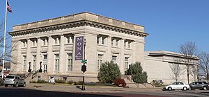
Museum of Nebraska Art
United States historic place
Distance: Approx. 1475 meters
Latitude and longitude: 40.69972222,-99.08111111
The Museum of Nebraska Art (MONA) is the official art museum of the state of Nebraska. The museum is located in Kearney, Nebraska, and is administratively affiliated with the University of Nebraska at Kearney. The official charter of MONA makes it home to the Nebraska Art Collection, which is home to works by artists who were born in Nebraska, have lived in Nebraska, or have some connection to Nebraska.
Kearney Catholic High School
Private, coeducational school in Kearney, , Nebraska, United States
Distance: Approx. 260 meters
Latitude and longitude: 40.71055556,-99.07916667
Kearney Catholic High School is a private, Roman Catholic high school in Kearney, Nebraska, United States. It is located in the Roman Catholic Diocese of Grand Island.
Kearney Public Schools
School district in Nebraska, United States
Distance: Approx. 1546 meters
Latitude and longitude: 40.700162,-99.085886
Kearney Public Schools is a school district serving the area of Kearney, Nebraska, United States.
KLPR
Radio station in Kearney, Nebraska
Distance: Approx. 1764 meters
Latitude and longitude: 40.70416667,-99.09583333
KLPR (91.1 FM) is a radio station broadcasting an alternative music format. Licensed to Kearney, Nebraska, United States, the station is owned by the University of Nebraska at Kearney.

Saint Luke's Protestant Episcopal Church
Historic church in Nebraska, United States
Distance: Approx. 1483 meters
Latitude and longitude: 40.70555556,-99.09305556
Saint Luke's Protestant Episcopal Church (St. Luke's Episcopal Church) is a historic church at 2304 Second Avenue in Kearney, Nebraska. It was designed by Chicago architect John Sutcliffe and was built in 1908.
Kearney Memorial Field
Distance: Approx. 1276 meters
Latitude and longitude: 40.70913,-99.09262
Kearney Memorial Field is a baseball ballpark located in Kearney, Nebraska. It is currently the home stadium of the University of Nebraska at Kearney baseball team and once served as the home field for the Kearney Yankees, a New York Yankees Class "D" minor league affiliate in the Nebraska League. and The Kearney Irishmen The Stadium replaced the ballpark at the fairgrounds.

John Barnd House
United States historic place
Distance: Approx. 737 meters
Latitude and longitude: 40.70638889,-99.07611111
The John Barnd House is a historic house in Kearney, Nebraska. It was built in 1892 for John Barnd, a veteran of the Union Army during the Civil War of 1861-1865 who founded the Mutual Loan and Investment Company of Kearney and was the co-owner of the Commercial and Savings Bank of Kearney. The house was designed in the Queen Anne architectural style.

Hanson-Downing House
United States historic place
Distance: Approx. 2018 meters
Latitude and longitude: 40.69805556,-99.09222222
The Hanson-Downing House is a historic house in Kearney, Nebraska. It was built in 1886 as a cottage orné by Charles E. Hanson, a Swedish immigrant. It later belonged to Wallace A. Downing, a businessman in the saddlery and harness industry.

Fort Theater
United States historic place
Distance: Approx. 1689 meters
Latitude and longitude: 40.69777778,-99.08111111
Fort Theater is a historic two-story building in Kearney, Nebraska. It was built in 1914 as The Empress by F.G. Keens, and designed in the Classical Revival style. After it was partly destroyed in 1940, it was purchased by Don and George Monroe, who added a marquee to the facade; it was designed in the Moderne style by architect Edward J. Sessinghaus.

World Theatre
Historic movie theater in Kearney, Nebraska
Distance: Approx. 1555 meters
Latitude and longitude: 40.69912442,-99.08208275
The World Theatre is a historic movie theater and performing arts center in Kearney, Nebraska. The building, which also housed a Masonic Temple on its upper three floors, was designed by James T. Allen in the Classical Revival style. It is listed in the National Register of Historic Places.
Weather in this IP's area
few clouds
14 Celsius
13 Celsius
14 Celsius
15 Celsius
1015 hPa
50 %
1015 hPa
939 hPa
10000 meters
8.23 m/s
180 degree
20 %
07:51:08
18:51:14