24.172.248.27 - IP Lookup: Free IP Address Lookup, Postal Code Lookup, IP Location Lookup, IP ASN, Public IP
Country:
 USA
USARegion:
City:
Location:
Time Zone:
Postal Code:
ISP:
ASN:
language:
User-Agent:
Proxy IP:
Blacklist:
IP information under different IP Channel
ip-api
Country
Region
City
ASN
Time Zone
ISP
Blacklist
Proxy
Latitude
Longitude
Postal
Route
db-ip
Country
Region
City
ASN
Time Zone
ISP
Blacklist
Proxy
Latitude
Longitude
Postal
Route
IPinfo
Country
Region
City
ASN
Time Zone
ISP
Blacklist
Proxy
Latitude
Longitude
Postal
Route
IP2Location
24.172.248.27Country
usRegion
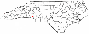
north carolina
City
gastonia
Time Zone
America/New_York
ISP
Language
User-Agent
Latitude
Longitude
Postal
ipdata
Country
Region
City
ASN
Time Zone
ISP
Blacklist
Proxy
Latitude
Longitude
Postal
Route
Popular places and events near this IP address

Gastonia, North Carolina
City in North Carolina, United States
Distance: Approx. 4482 meters
Latitude and longitude: 35.24916667,-81.18555556
Gastonia is the most populous city in and the county seat of Gaston County, North Carolina, United States. It is the second-largest satellite city of the Charlotte area, behind Concord. The population was 80,411 in the 2020 census, up from 71,741 in 2010.
Lowell, North Carolina
City in North Carolina, United States
Distance: Approx. 4301 meters
Latitude and longitude: 35.24972222,-81.10194444
Lowell is a small city in Gaston County, North Carolina, United States, located east of Gastonia. The population was 3,526 at the 2010 census.

Gastonia station
Train station in Gastonia, North Carolina
Distance: Approx. 4758 meters
Latitude and longitude: 35.2692,-81.1624
Gastonia station is an Amtrak train station in Gastonia, North Carolina, United States. Located at 350 Hancock Street, it is about 1.5 miles (2.4 km) northeast of downtown Gastonia.

Gastonia Municipal Airport
Airport
Distance: Approx. 3070 meters
Latitude and longitude: 35.20277778,-81.14972222
Gastonia Municipal Airport (ICAO: KAKH, FAA LID: AKH) is a city-owned, public-use airport located four nautical miles (5 mi, 7 km) south of the central business district of Gastonia, a city in Gaston County, North Carolina, United States. It is included in the National Plan of Integrated Airport Systems for 2011–2015, which categorized it as a general aviation facility. This airport is assigned a three-letter location identifier of AKH by the Federal Aviation Administration, but it does not have an International Air Transport Association (IATA) airport code (the IATA assigned AKH to Prince Sultan Air Base in Al Kharj, Saudi Arabia).
Gaston Christian School
American private school in North Carolina
Distance: Approx. 4565 meters
Latitude and longitude: 35.2523,-81.1005
Gaston Christian School is a private Christian school located in Lowell, North Carolina.

Eastridge Mall (Gastonia)
Shopping mall in North Carolina, United States
Distance: Approx. 3949 meters
Latitude and longitude: 35.2649,-81.1478
Eastridge Mall (formerly known as Westfield Eastridge) is a regional shopping mall located in Gastonia, North Carolina, and is 19 miles (31 km) west of uptown Charlotte, North Carolina. Opened in 1976, it is located off Interstate 85 at exit 20, N. New Hope Road (North Carolina Highway 279), and the mall houses around 70 stores. As part of the mall's sale, the mall reverted to its former name, Eastridge Mall.
Ashbrook High School (North Carolina)
High school in Gastonia, North Carolina
Distance: Approx. 2097 meters
Latitude and longitude: 35.24388889,-81.12722222
Ashbrook High School is a public high school in the Gaston County Schools public school district located in Gastonia, North Carolina. The school was the result of the merger of two former senior high schools, Holbrook Senior High and Ashley Senior High. The first class graduated in 1971.
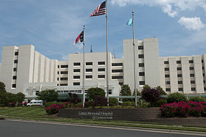
CaroMont Regional Medical Center
Hospital in North Carolina, United States
Distance: Approx. 4675 meters
Latitude and longitude: 35.2716323,-81.1396011
CaroMont Regional Medical Center is a not-for-profit hospital located in Gastonia, North Carolina, United States. The hospital was organized in 1946 as a memorial to soldiers who died in World War II, and the present Court Drive facility opened in 1973.
David A. Jenkins
American politician
Distance: Approx. 4603 meters
Latitude and longitude: 35.26611111,-81.16638889
David Aaron Jenkins (April 5, 1822 – September 10, 1886) was a Republican politician and North Carolina State Treasurer from 1868 until 1876. His home was listed on the National Register of Historic Places before being demolished.
Boogertown, North Carolina
Unincorporated community in North Carolina, United States
Distance: Approx. 2040 meters
Latitude and longitude: 35.21805556,-81.15972222
Boogertown is an unincorporated community in Gaston County, North Carolina, United States. Moonshiners who warned that the bogeyman lurked in the forest in order to deter visitors caused the name Boogertown to be selected.

Gastonia High School
Historic school building in North Carolina, United States
Distance: Approx. 4925 meters
Latitude and longitude: 35.25277778,-81.18861111
Gastonia High School is a historic high school building located at Gastonia, Gaston County, North Carolina. It was designed by Hugh Edward White and built in 1922–1924. It is a five-story, heavily ornamented E-shaped Tudor Revival-style red brick school.
Disappearance of Jamie Fraley
North Carolina disappearance case
Distance: Approx. 4329 meters
Latitude and longitude: 35.2433,-81.0978
In the early hours of April 8, 2008, Jamie Fraley (born March 5, 1986), of Gastonia, North Carolina, United States, told a friend over the phone that she was going to the hospital for the third time in the last 24 hours due to a stomach flu. When asked who was taking her there, Fraley said it was another friend and declined to further identify that person. She has not been seen since; her cellphone was found a few days later but provided no useful information as to her whereabouts.
Weather in this IP's area
clear sky
13 Celsius
12 Celsius
11 Celsius
14 Celsius
1022 hPa
65 %
1022 hPa
994 hPa
10000 meters
2.06 m/s
160 degree