Country:
 USA
USARegion:
City:
Latitude and Longitude:
Time Zone:
Postal Code:
IP information under different IP Channel
ip-api
Country
Region
City
ASN
Time Zone
ISP
Blacklist
Proxy
Latitude
Longitude
Postal
Route
IPinfo
Country
Region
City
ASN
Time Zone
ISP
Blacklist
Proxy
Latitude
Longitude
Postal
Route
MaxMind
Country
Region
City
ASN
Time Zone
ISP
Blacklist
Proxy
Latitude
Longitude
Postal
Route
Luminati
Country
USRegion
oh
City
massillon
ASN
Time Zone
America/New_York
ISP
MASSCOM
Latitude
Longitude
Postal
db-ip
Country
Region
City
ASN
Time Zone
ISP
Blacklist
Proxy
Latitude
Longitude
Postal
Route
ipdata
Country
Region
City
ASN
Time Zone
ISP
Blacklist
Proxy
Latitude
Longitude
Postal
Route
Popular places and events near this IP address

Massillon, Ohio
City in Ohio, United States
Distance: Approx. 3896 meters
Latitude and longitude: 40.78555556,-81.52527778
Massillon is a city in Stark County, Ohio, United States, approximately 8 miles (13 km) west of Canton, 20 miles (32 km) south of Akron, and 50 miles (80 km) south of Cleveland. The population was 32,146 at the 2020 census. Massillon is the second largest city within the Canton–Massillon metropolitan area, which includes all of Stark and Carroll counties and had a population of 401,574 in 2020.

Perry Heights, Ohio
Census-designated place in Ohio, United States
Distance: Approx. 2996 meters
Latitude and longitude: 40.79777778,-81.46805556
Perry Heights is a census-designated place in Stark County, Ohio, United States. The population was 8,391 at the 2020 census. It is part of the Canton–Massillon metropolitan area.

Massillon Washington High School
Public high school in Massillon, Ohio, United States
Distance: Approx. 2347 meters
Latitude and longitude: 40.792678,-81.502912
Washington High School, commonly referred to as Massillon High School or Massillon Washington High School, is a 9th to 12th grade secondary school within the Massillon City School District in the city of Massillon, Ohio. The school colors are orange and black, and the school's athletic teams are known as the Massillon Tigers.

Paul Brown Tiger Stadium
Distance: Approx. 2211 meters
Latitude and longitude: 40.793544,-81.499746
Paul Brown Tiger Stadium is a high school football stadium located in Massillon, Ohio. It is primarily used for American football, and is the home field of the Massillon Washington High School Tigers football team. The stadium has a seating capacity of 16,600 spectators, with a maximum capacity of over 19,000 when extra seating is brought in.

Perry High School (Stark County, Ohio)
School in Canton, Ohio, United States
Distance: Approx. 3927 meters
Latitude and longitude: 40.7891,-81.4632
Perry High School is a public high school in Perry Township, Ohio, United States near Massillon. It is the only public high school in the Perry Local School District in Stark County.

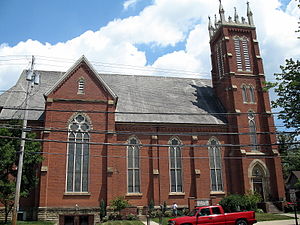
First Methodist Episcopal Church (Massillon, Ohio)
Historic church in Ohio, United States
Distance: Approx. 2577 meters
Latitude and longitude: 40.79725,-81.51913889
First Methodist Episcopal Church (now known as First United Methodist Church) is a historic church in Massillon, Ohio, United States, located at 301 Lincoln Way East. It is of stone and sandstone construction with a copper roof in the Richardsonian Romanesque style. The building was dedicated in June 1895 and was added to the U.S. National Register of Historic Places on August 22, 1985.
Canton–Massillon, Ohio, metropolitan area
Metropolitan Statistical Area in Ohio, United States
Distance: Approx. 2961 meters
Latitude and longitude: 40.8,-81.46666667
The Canton–Massillon Metropolitan Statistical Area, as defined by the United States Census Bureau, is an area consisting of two counties in Northeast Ohio, anchored by the cities of Canton and Massillon. As of the 2020 census, the MSA had a population of 401,574. The MSA is also part of the Cleveland–Akron–Canton, OH Combined Statistical Area, which had a population of 3,633,962 in 2020, making it the largest CSA in Ohio.

St. Timothy's Protestant Episcopal Church
Historic church in Ohio, United States
Distance: Approx. 2634 meters
Latitude and longitude: 40.79555556,-81.51777778
St. Timothy's Protestant Episcopal Church is a historic church at 226 SE. 3rd Street in Massillon, Ohio. It was built in 1892 and added to the National Register in 1979.

St. Mary's Catholic Church (Massillon, Ohio)
United States historic place
Distance: Approx. 2490 meters
Latitude and longitude: 40.80222222,-81.52277778
St. Mary's Catholic Church is a historic Catholic church building in the city of Massillon, Ohio, United States. Constructed in 1876 for a congregation composed largely of European immigrants, it has been named a historic site.
Saint Joseph's Roman Catholic Church (Massillon, Ohio)
Historic church in Ohio, United States
Distance: Approx. 2737 meters
Latitude and longitude: 40.79416667,-81.5175
Saint Joseph's Roman Catholic Church is a historic church at 322 3rd Street SE in Massillon, Ohio, United States. The designer was John Verment, a French-born architect who also contributed to the design of St. Mary's Catholic Church elsewhere in Massillon.
Newman Creek
Stream in Ohio
Distance: Approx. 2666 meters
Latitude and longitude: 40.80833333,-81.52805556
Newman Creek is a stream in the U.S. state of Ohio. Newman Creek has the name of Jacob Newman, a government surveyor.

Spring Hill Historic Home
Historic site of Underground Railroad
Distance: Approx. 769 meters
Latitude and longitude: 40.81213,-81.5061
Spring Hill is a historic home museum in Massillon, Ohio. The estate was settled and started by Thomas and Charity Rotch, and it was eventually owned by the Wales family for three generations. Spring Hill is recognized on the National Park Service Underground Railroad Network to Freedom.
Weather in this IP's area
broken clouds
12 Celsius
11 Celsius
11 Celsius
14 Celsius
1021 hPa
63 %
1021 hPa
984 hPa
10000 meters
1.34 m/s
4.92 m/s
113 degree
67 %
07:00:22
19:46:59