24.138.246.111 - IP Lookup: Free IP Address Lookup, Postal Code Lookup, IP Location Lookup, IP ASN, Public IP
Country:
Region:
City:
Location:
Time Zone:
Postal Code:
ISP:
ASN:
language:
User-Agent:
Proxy IP:
Blacklist:
IP information under different IP Channel
ip-api
Country
Region
City
ASN
Time Zone
ISP
Blacklist
Proxy
Latitude
Longitude
Postal
Route
db-ip
Country
Region
City
ASN
Time Zone
ISP
Blacklist
Proxy
Latitude
Longitude
Postal
Route
IPinfo
Country
Region
City
ASN
Time Zone
ISP
Blacklist
Proxy
Latitude
Longitude
Postal
Route
IP2Location
24.138.246.111Country
Region
aguada
City
luyando
Time Zone
America/Puerto_Rico
ISP
Language
User-Agent
Latitude
Longitude
Postal
ipdata
Country
Region
City
ASN
Time Zone
ISP
Blacklist
Proxy
Latitude
Longitude
Postal
Route
Popular places and events near this IP address

Aguada, Puerto Rico
Town and municipality in Puerto Rico
Distance: Approx. 3672 meters
Latitude and longitude: 18.37944444,-67.18833333
Aguada (; Spanish: [aˈɣwaða], locally [aˈwaða]), originally San Francisco de Asís de la Aguada, is a town and municipality of Puerto Rico, located in the northwestern coastal valley region bordering the Atlantic Ocean, east of Rincón, south of Aguadilla, west of Moca; and north of Añasco and Mayagüez. It is part of the Aguadilla-Isabela-San Sebastián Metropolitan Statistical Area. Aguada's population is spread over 17 barrios and Aguada Pueblo (the downtown area and the administrative center of the city).
Río Cañas (Aguada, Puerto Rico)
River of Puerto Rico
Distance: Approx. 3205 meters
Latitude and longitude: 18.3882802,-67.1404582
The Río Cañas (Aguada, Puerto Rico) is a river of Puerto Rico.

Central Coloso
Former sugarcane refinery in Aguada, Puerto Rico
Distance: Approx. 1904 meters
Latitude and longitude: 18.3811,-67.1613
Central Coloso, also known as Coloso Sugar Cane Refinery, was a long-running sugarcane refinery in Aguada, Puerto Rico. The refinery was established in late 19th century becoming one of the biggest sugar emporiums in the island. It remained operational until 2003, becoming the last sugarcane refinery to cease operations on the island.

Asomante, Aguada, Puerto Rico
Barrio of Puerto Rico
Distance: Approx. 2688 meters
Latitude and longitude: 18.383965,-67.172313
Asomante is a barrio in the municipality of Aguada, Puerto Rico. Its population in 2010 was 3,177.

Naranjo, Aguada, Puerto Rico
Barrio of Puerto Rico
Distance: Approx. 2117 meters
Latitude and longitude: 18.345381,-67.157669
Naranjo is a barrio in the municipality of Aguada, Puerto Rico. Its population in 2010 was 3,292.

Mamey, Aguada, Puerto Rico
Barrio of Puerto Rico
Distance: Approx. 2258 meters
Latitude and longitude: 18.377302,-67.140906
Mamey is a barrio in the municipality of Aguada, Puerto Rico. Its population in 2010 was 2,400.

Piedras Blancas, Aguada, Puerto Rico
Barrio of Puerto Rico
Distance: Approx. 3031 meters
Latitude and longitude: 18.363046,-67.186051
Piedras Blancas is a barrio in the municipality of Aguada, Puerto Rico. Its population in 2010 was 4,635.

Marías, Aguada, Puerto Rico
Barrio of Puerto Rico
Distance: Approx. 2105 meters
Latitude and longitude: 18.359339,-67.138207
Marías is a barrio in the municipality of Aguada, Puerto Rico. Its population in 2010 was 1,997.

Guanábano, Aguada, Puerto Rico
Barrio of Puerto Rico
Distance: Approx. 1883 meters
Latitude and longitude: 18.381187,-67.155223
Guanábano is a barrio in the municipality of Aguada, Puerto Rico. Its population in 2010 was 749.

Lagunas, Aguada, Puerto Rico
Barrio of Puerto Rico
Distance: Approx. 3340 meters
Latitude and longitude: 18.337512,-67.171434
Lagunas is a barrio in the municipality of Aguada, Puerto Rico. Its population in 2010 was 2,810.

Mal Paso, Aguada, Puerto Rico
Barrio of Puerto Rico
Distance: Approx. 1275 meters
Latitude and longitude: 18.365988,-67.169352
Mal Paso is a barrio in the municipality of Aguada, Puerto Rico. Its population in 2010 was 2,483.

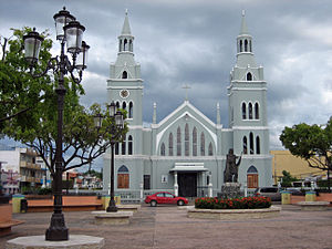
Church of San Francisco de Asís
Church in Aguada, Puerto Rico
Distance: Approx. 3686 meters
Latitude and longitude: 18.37972222,-67.18833333
The Church of San Francisco de Asís de la Aguada (Spanish: Iglesia San Francisco de Asís de la Aguada) is a parish of the Catholic Church in Aguada, Puerto Rico. It is located on the eastern end of the Plaza de Aguada (the main town square) in downtown Aguada.
Weather in this IP's area
broken clouds
26 Celsius
26 Celsius
25 Celsius
27 Celsius
1017 hPa
81 %
1017 hPa
1009 hPa
10000 meters
6.17 m/s
7.72 m/s
40 degree
75 %