Country:
 USA
USARegion:
City:
Latitude and Longitude:
Time Zone:
Postal Code:
IP information under different IP Channel
ip-api
Country
Region
City
ASN
Time Zone
ISP
Blacklist
Proxy
Latitude
Longitude
Postal
Route
IPinfo
Country
Region
City
ASN
Time Zone
ISP
Blacklist
Proxy
Latitude
Longitude
Postal
Route
MaxMind
Country
Region
City
ASN
Time Zone
ISP
Blacklist
Proxy
Latitude
Longitude
Postal
Route
Luminati
Country
USRegion
ks
City
lawrence
ASN
Time Zone
America/Chicago
ISP
MIDCO-NET
Latitude
Longitude
Postal
db-ip
Country
Region
City
ASN
Time Zone
ISP
Blacklist
Proxy
Latitude
Longitude
Postal
Route
ipdata
Country
Region
City
ASN
Time Zone
ISP
Blacklist
Proxy
Latitude
Longitude
Postal
Route
Popular places and events near this IP address

Haskell Indian Nations University
Public university in Lawrence, Kansas
Distance: Approx. 860 meters
Latitude and longitude: 38.93972222,-95.23277778
Haskell Indian Nations University is a public tribal land-grant university in Lawrence, Kansas, United States. Founded in 1884 as a residential boarding school for Native American children, the school has developed into a university operated by the U.S. Bureau of Indian Affairs that offers both associate and baccalaureate degrees. The college was founded to serve members of federally recognized Native American tribes in the United States.
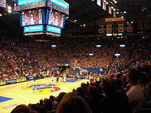
Allen Fieldhouse
University of Kansas basketball arena
Distance: Approx. 2570 meters
Latitude and longitude: 38.95430556,-95.25239444
Allen Fieldhouse is an indoor arena on the University of Kansas (KU) campus in Lawrence, Kansas. It is home of the Kansas Jayhawks men's and women's basketball teams. The arena is named after Phog Allen, a former player and head coach for the Jayhawks whose tenure lasted 39 years.

University of Kansas Natural History Museum
United States historic place
Distance: Approx. 2805 meters
Latitude and longitude: 38.95861111,-95.24388889
The University of Kansas Natural History Museum is part of the University of Kansas Biodiversity Institute, a KU designated research center dedicated to the study of the life of the planet. The museum's galleries are in Dyche Hall on the university's main campus in Lawrence, Kansas. The galleries are open from 9 a.m.
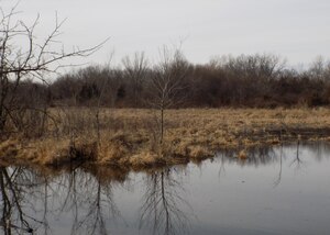
Haskell-Baker Wetlands
Nature preserve in Kansas
Distance: Approx. 1959 meters
Latitude and longitude: 38.91666667,-95.23333333
The Baker Wetlands (also known as the Haskell-Baker Wetlands) is a nature preserve and artificially sustained wetland, spanning approximately 927 acres (3.8 km2) south of Lawrence, Kansas, United States. It is associated with the Wakarusa River and sustained by levees and flood controls built in the 1990s. Baker University owns 573 acres, the major portion of the site; Haskell Indian Nations University holds 27 acres, and the Kansas Department of Wildlife and Parks, and the University of Kansas hold 20 acres each.
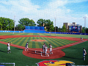
Hoglund Ballpark
Baseball stadium in Lawrence, Kansas, US
Distance: Approx. 2460 meters
Latitude and longitude: 38.952955,-95.252938
Hoglund Ballpark is a baseball stadium in Lawrence, Kansas. It is the home field for the University of Kansas' baseball team. The stadium holds 3,000 people and opened for baseball in 1958.
Lawrence High School (Kansas)
High school in Lawrence, Kansas, United States
Distance: Approx. 1745 meters
Latitude and longitude: 38.949085,-95.242871
Lawrence High School (LHS) is a public secondary school in Lawrence, Kansas, United States, operated by Lawrence USD 497 school district, and serves students of grades 9 to 12. The school is one of the two public high schools located in the city. Lawrence High enrolled 1,575 students in the 2020–2021 school year.

Wakarusa Township, Kansas
Township in Kansas, United States
Distance: Approx. 1482 meters
Latitude and longitude: 38.93611111,-95.25583333
Wakarusa Township is a township in Douglas County, Kansas, United States. As of the 2010 census, its population was 2,318. It was named for the Wakarusa River which flows through Douglas County from Wabaunsee County to the Kansas River near Eudora.
University of Kansas School of Business
Public business school
Distance: Approx. 2604 meters
Latitude and longitude: 38.95555556,-95.24972222
The University of Kansas School of Business is a public business school on the main campus of the University of Kansas in Lawrence, Kansas. The KU School of Business was founded in 1924 and has more than 100 faculty members and approximately 1500 students. The Association to Advance Collegiate Schools of Business has accredited the KU School of Business for its business and accounting programs.
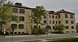
Bailey Hall (University of Kansas)
United States historic place
Distance: Approx. 2750 meters
Latitude and longitude: 38.95777778,-95.24611111
Bailey Hall (formerly known as the Chemistry Building), at the University of Kansas in Lawrence, Kansas, was built in 1905. The architect was John G. Haskell who was among the architects of the Kansas State Capitol. It was listed on the National Register of Historic Places in 2001.

Haskell Memorial Stadium
Distance: Approx. 1074 meters
Latitude and longitude: 38.94055556,-95.23027778
Haskell Memorial Stadium is a sport stadium in Lawrence, Kansas. The facility is primarily used by Haskell Indian Nations University for college football and formerly by local high school teams. Haskell discontinued their football program in 2015.
Center for International Political Analysis
Research center at the University of Kansas
Distance: Approx. 2526 meters
Latitude and longitude: 38.956105,-95.243633
The Center for International Political Analysis (CIPA) is a research center at the Policy Research Institute (PRI) at the University of Kansas. At present, the project's primary focus is to gather information regarding the nature of inter-state relations during times of conflict in several localized areas, such as the Middle East, Southern, Western, and Central Africa, and the Balkans.

Robinson Gymnasium
Gymnasium at the University of Kansas in Lawrence, Kansas
Distance: Approx. 2720 meters
Latitude and longitude: 38.95722222,-95.2475
Robinson Gymnasium was the first true gymnasium for the University of Kansas (KU) in Lawrence, Kansas and home to the Kansas Jayhawks men's basketball program from 1907 to 1927. It was designed by James Naismith at a cost of $100,000. The creation of the modern facilities were led by Naismith and Chancellor Frank Strong.
Weather in this IP's area
clear sky
17 Celsius
16 Celsius
15 Celsius
19 Celsius
1019 hPa
44 %
1019 hPa
989 hPa
10000 meters
2.06 m/s
70 degree
07:22:53
18:54:04