24.123.149.59 - IP Lookup: Free IP Address Lookup, Postal Code Lookup, IP Location Lookup, IP ASN, Public IP
Country:
Region:
City:
Location:
Time Zone:
Postal Code:
ISP:
ASN:
language:
User-Agent:
Proxy IP:
Blacklist:
IP information under different IP Channel
ip-api
Country
Region
City
ASN
Time Zone
ISP
Blacklist
Proxy
Latitude
Longitude
Postal
Route
db-ip
Country
Region
City
ASN
Time Zone
ISP
Blacklist
Proxy
Latitude
Longitude
Postal
Route
IPinfo
Country
Region
City
ASN
Time Zone
ISP
Blacklist
Proxy
Latitude
Longitude
Postal
Route
IP2Location
24.123.149.59Country
Region
north carolina
City
morehead city
Time Zone
America/New_York
ISP
Language
User-Agent
Latitude
Longitude
Postal
ipdata
Country
Region
City
ASN
Time Zone
ISP
Blacklist
Proxy
Latitude
Longitude
Postal
Route
Popular places and events near this IP address

Atlantic Beach, North Carolina
Town in North Carolina, United States
Distance: Approx. 2751 meters
Latitude and longitude: 34.70194444,-76.74194444
Atlantic Beach is a town in Carteret County, North Carolina, United States. It is one of the five communities located on Bogue Banks. The population was 1,364 at the 2020 census.

Morehead City, North Carolina
City in North Carolina, United States
Distance: Approx. 1458 meters
Latitude and longitude: 34.73027778,-76.73916667
Morehead City is a port city in Carteret County, North Carolina, United States. The population was 8,661 at the 2010 census. Morehead City celebrated the 150th anniversary of its founding on May 5, 2007.

Fort Macon State Park
State park in North Carolina, United States
Distance: Approx. 4561 meters
Latitude and longitude: 34.69555556,-76.68888889
Fort Macon State Park is a North Carolina state park in Carteret County, North Carolina, in the United States. Located on Bogue Banks near Atlantic Beach, the park opened in 1936. Fort Macon State Park is the second most visited state park in North Carolina, with an annual visitation of 1.3 million, despite being one of the smallest state parks in North Carolina with 424 acres (1.72 km2).

Siege of Fort Macon
Action of the American Civil War
Distance: Approx. 5242 meters
Latitude and longitude: 34.69611111,-76.67888889
The siege of Fort Macon took place from March 23 to April 26, 1862, on the Outer Banks of Carteret County, North Carolina. It was part of Union Army General Ambrose E. Burnside's North Carolina Expedition during the American Civil War. In late March, Major General Burnside’s army advanced on Fort Macon, a casemated masonry fort that commanded the channel to Beaufort, 35 miles (56 km) southeast of New Bern.
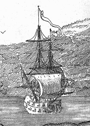
Queen Anne's Revenge
Pirate Blackbeard's ship
Distance: Approx. 4561 meters
Latitude and longitude: 34.69555556,-76.68888889
Queen Anne's Revenge was an early-18th-century ship, most famously used as a flagship by Edward Teach, better known by his nickname Blackbeard. The date and place of the ship's construction are uncertain, and there is no record of its actions prior to 1710 when it was operating as a French privateer as La Concorde. Surviving features of the ship's construction strongly suggest it was built by French shipwrights, based on differences in fastening patterns in the late 17th and early 18th centuries.

Crystal Coast
Coastal region of North Carolina, United States
Distance: Approx. 3445 meters
Latitude and longitude: 34.695285,-76.70901
In North Carolina, the Crystal Coast is an 85-mile stretch of coastline that extends from the Cape Lookout National Seashore, which includes 56 miles of protected beaches, southwestward to the New River. The Crystal Coast is a popular area with tourists and second-home owners in the summer, with a name coined by the Carteret County Tourism Development Authority. The absolute boundaries of this coast are often disputed, but the main area includes all the major Carteret County beaches (those on Bogue Banks, which face south).
Carteret Community College
College in Morehead City, North Carolina, U.S.
Distance: Approx. 2748 meters
Latitude and longitude: 34.7237,-76.75602
Carteret Community College is a public community college in Morehead City, North Carolina. It was founded in 1963 and serves residents of Carteret County, North Carolina. Carteret Community College is one of 58 institutions comprising the North Carolina Community College System.
O'Neal Field at Big Rock Stadium
Baseball venue in North Carolina, USA
Distance: Approx. 1651 meters
Latitude and longitude: 34.7366,-76.7329
Puck O'Neal Field at Big Rock Stadium is a baseball venue in Morehead City, North Carolina, United States. Also known as simply Big Rock Stadium, the venue is home to the Morehead City Marlins of the Coastal Plain League, a collegiate summer baseball league. The Marlins began play at the field for the 2010 season, after their arrival was announced in the fall of 2009.
Carteret Health Care
Hospital in North Carolina, United States
Distance: Approx. 2679 meters
Latitude and longitude: 34.7262,-76.755
Carteret Health Care (formerly Carteret General Hospital) is a 135-bed, non-profit hospital in Morehead City, North Carolina. Carteret General was founded in 1967.
Morehead City Municipal Building
United States historic place
Distance: Approx. 1195 meters
Latitude and longitude: 34.72027778,-76.71333333
Morehead City Municipal Building is a historic municipal building located at Morehead City, Carteret County, North Carolina. It was built in 1926, and is a two-story, stuccoed brick building in the Florentine Renaissance style. It has a low hipped roof and an in-antis porch, with two stone, full height, engaged Ionic order columns.

Morehead City Historic District
National Register Historic District in North Carolina, United States
Distance: Approx. 1084 meters
Latitude and longitude: 34.7225,-76.71416667
' In 2003, the US Department of Interior - National Park Service listed the National Register of Historic Places Morehead City Historic District (NRHD). It is located near the downtown waterfront of Morehead City, Carteret County, North Carolina. Within the NRHD boundary originally were 123 Contributing Resource (CR) buildings.
Calico Bay
Bay in North Carolina, United States
Distance: Approx. 1537 meters
Latitude and longitude: 34.7307168,-76.7121541
Calico Bay is a bay in Carteret County, North Carolina, in the United States. Calico Bay was named for its colorful bed thanks to abundant deposits of loam.
Weather in this IP's area
light rain
6 Celsius
2 Celsius
4 Celsius
6 Celsius
1025 hPa
81 %
1025 hPa
1024 hPa
10000 meters
6.69 m/s
11.32 m/s
30 degree
100 %

