24.123.120.252 - IP Lookup: Free IP Address Lookup, Postal Code Lookup, IP Location Lookup, IP ASN, Public IP
Country:
 USA
USARegion:
City:
Location:
Time Zone:
Postal Code:
ISP:
ASN:
language:
User-Agent:
Proxy IP:
Blacklist:
IP information under different IP Channel
ip-api
Country
Region
City
ASN
Time Zone
ISP
Blacklist
Proxy
Latitude
Longitude
Postal
Route
db-ip
Country
Region
City
ASN
Time Zone
ISP
Blacklist
Proxy
Latitude
Longitude
Postal
Route
IPinfo
Country
Region
City
ASN
Time Zone
ISP
Blacklist
Proxy
Latitude
Longitude
Postal
Route
IP2Location
24.123.120.252Country
usRegion
california
City
temecula
Time Zone
America/Los_Angeles
ISP
Language
User-Agent
Latitude
Longitude
Postal
ipdata
Country
Region
City
ASN
Time Zone
ISP
Blacklist
Proxy
Latitude
Longitude
Postal
Route
Popular places and events near this IP address

Temecula, California
City in California, United States
Distance: Approx. 2543 meters
Latitude and longitude: 33.50333333,-117.12361111
Temecula (; Spanish: Temécula, [te'mekula]; Luiseño: Temeekunga) is a city in southwestern Riverside County, California, United States. The city had a population of 110,003 as of the 2020 census and was incorporated on December 1, 1989. The city is a tourist and resort destination, with the Temecula Valley Wine Country, Old Town Temecula, the Temecula Valley Balloon & Wine Festival, the Temecula Valley International Film Festival, championship golf courses, and resort accommodations contributing to the city's economic profile.

KMYT (FM)
Radio station in Temecula, California
Distance: Approx. 3561 meters
Latitude and longitude: 33.4809,-117.1836
KMYT (94.5 MHz) is an alternative rock FM radio station in Temecula, California. The station is owned and operated by iHeartMedia, Inc. The station's webcast is on the iHeartRadio app.
KTMQ
Radio station in Temecula, California
Distance: Approx. 3590 meters
Latitude and longitude: 33.481,-117.184
KTMQ (103.3 FM) is an active rock radio station that serves the Temecula Valley and Inland Empire areas. The station is owned by iHeartMedia, Inc.
Temecula Valley High School
Public high school in Temecula, California, United States
Distance: Approx. 3123 meters
Latitude and longitude: 33.50222222,-117.11638889
Temecula Valley High School, known by locals as TV, is a public high school for grades 9 to 12 in Temecula, California. The school opened in 1985 as the city's first high school. When it was built, it was a part of the Elsinore Union High School District (now the Lake Elsinore Unified School District) until the Temecula Valley Unified School District was founded.
Promenade Temecula
Regional shopping mall in Temecula, California, United States
Distance: Approx. 3536 meters
Latitude and longitude: 33.525,-117.15416667
Promenade Temecula, formerly The Promenade in Temecula, is an enclosed shopping mall in Temecula, California. Opened on October 27, 1999, its anchor tenants are J. C. Penney, Macy's which occupies two anchor spots: Macy's North (which was a former Robinsons-May) and Macy's South (which preceded North), Round One Entertainment, Edwards Cinema, and Dick's Sporting Goods.
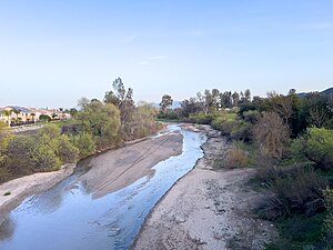
Temecula Creek
River in California, United States
Distance: Approx. 2275 meters
Latitude and longitude: 33.47416667,-117.14083333
Temecula Creek, formerly known as the Temecula River, runs 32.6 miles (52.5 km) through southern Riverside County, California, United States, past the rural communities of Radec and Aguanga, and ending 0.5 miles (0.80 km) southeast of the original city center of Temecula. The creek is filled with boulders and is typically dry and sandy. It is a relatively undeveloped coastal-draining watershed.
Grace Mellman Community Library
Public library in Temecula, California, United States. Part of Riverside County Library System
Distance: Approx. 3850 meters
Latitude and longitude: 33.52666667,-117.16055556
The Grace Mellman Community Library (Temecula County Center Library), located in Temecula, California, is a member of the Riverside County Library System. As a full-service library, it has over 80,000 items, and offers materials, programs, and services for all ages which include guest speakers, free movie nights and a monthly book club. To reach the children's room, students pass through a "magic tunnel", an experience shared by many first-grade students in the city.
Linfield Christian School
Private school in the United States
Distance: Approx. 3504 meters
Latitude and longitude: 33.50083333,-117.11166667
Linfield Christian School (LCS) is a private, co-educational, college-preparatory K-12 Christian school located on a 100-acre campus in Temecula, California, a city that is located between San Diego and Los Angeles. The school’s colors are navy blue, light blue and white, and the school mascot is the Lion. The current student enrollment is approximately 1,100 students.
Murrieta Creek
River in California, United States
Distance: Approx. 2222 meters
Latitude and longitude: 33.47444444,-117.14166667
Murrieta Creek runs 13 miles (21 km) southeasterly through southwestern Riverside County, California, United States, through the cities of Wildomar, Murrieta, and Temecula, ending 0.5 miles (0.80 km) southeast of the city center of Temecula, where it has its confluence with Temecula Creek and forms the head of the Santa Margarita River.
Pauba Valley
Distance: Approx. 3612 meters
Latitude and longitude: 33.47388889,-117.1175
Pauba Valley is a valley along the course of Temecula Creek, in Riverside County, California. It heads to the east at 33°30′06″N 117°00′10″W, the mouth of the gorge of Temecula Creek Canyon at the foot of Oak Mountain. Its mouth in the west is at an elevation of 1,014 feet (309 m), where it joins the Elsinore Trough at the confluence of Wolf Valley and Temecula Valley.
KKLM (FM)
K-Love radio station in Murrieta, California
Distance: Approx. 3102 meters
Latitude and longitude: 33.4663,-117.1417
KKLM (104.1 FM, "104.1 K-Love") is a religious radio station licensed to serve Murrieta, California. Owned by the Educational Media Foundation, it is an affiliate of the K-Love network, and airs its CCM music format. KKLM currently operates under a Class A nonprofit broadcast license.

Temecula's Chapel of Memories
Historic building in Temecula, California
Distance: Approx. 464 meters
Latitude and longitude: 33.49697,-117.15134
The Chapel of Memories, formerly St. Catherine's of Alexandria Church, is an historic building in Temecula, California. Built in 1917, the building is now located in Sam Hicks Monument Park on the north side of Old Town Temecula.
Weather in this IP's area
clear sky
11 Celsius
9 Celsius
8 Celsius
13 Celsius
1016 hPa
66 %
1016 hPa
967 hPa
10000 meters