24.123.120.235 - IP Lookup: Free IP Address Lookup, Postal Code Lookup, IP Location Lookup, IP ASN, Public IP
Country:
 USA
USARegion:
City:
Location:
Time Zone:
Postal Code:
ISP:
ASN:
language:
User-Agent:
Proxy IP:
Blacklist:
IP information under different IP Channel
ip-api
Country
Region
City
ASN
Time Zone
ISP
Blacklist
Proxy
Latitude
Longitude
Postal
Route
db-ip
Country
Region
City
ASN
Time Zone
ISP
Blacklist
Proxy
Latitude
Longitude
Postal
Route
IPinfo
Country
Region
City
ASN
Time Zone
ISP
Blacklist
Proxy
Latitude
Longitude
Postal
Route
IP2Location
24.123.120.235Country
usRegion
california
City
inglewood
Time Zone
America/Los_Angeles
ISP
Language
User-Agent
Latitude
Longitude
Postal
ipdata
Country
Region
City
ASN
Time Zone
ISP
Blacklist
Proxy
Latitude
Longitude
Postal
Route
Popular places and events near this IP address
Inglewood, California
City in California, United States
Distance: Approx. 811 meters
Latitude and longitude: 33.9575,-118.34611111
Inglewood is a city in southwestern Los Angeles County, California, United States, in the Greater Los Angeles metropolitan area. As of the 2020 U.S. census, the city had a population of 107,762. It is in the South Bay region of Los Angeles County, near Los Angeles International Airport.

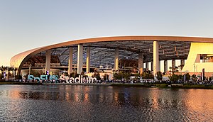
Kia Forum
Multi-purpose indoor arena in Inglewood, California, U.S.
Distance: Approx. 1133 meters
Latitude and longitude: 33.95833333,-118.34166667
The Kia Forum, also known as Los Angeles Forum and formerly Great Western Forum, is a multi-purpose indoor arena in Inglewood, California, United States, adjacent to Los Angeles. Located on West Manchester Boulevard, with Pincay Drive to the south and between Kareem Court and Prairie Avenue to the east and west, it is north of SoFi Stadium and the Hollywood Park Casino, and about 3 miles (4.8 km) east of Los Angeles International Airport (LAX). The Forum opened on December 30, 1967.

Thornton Chase
American poet
Distance: Approx. 1307 meters
Latitude and longitude: 33.96984,-118.342881
Thornton Chase (February 22, 1847 – September 30, 1912) was a distinguished officer of the United States Colored Troops during the American Civil War, and the first western convert to the Baháʼí Faith. Chase was born in Springfield, Massachusetts to parents of English background and Baptist religion. After being schooled for college by Rev.

City Honors High School
Public secondary school in Inglewood, California, United States
Distance: Approx. 894 meters
Latitude and longitude: 33.95857,-118.36207
City Honors High School (CHHS) also known as City Honors International Preparatory School, is a charter high school in the Inglewood Unified School District (IUSD), serving grades 9–12. City Honors International Preparatory School (CHIPS) received another 6-year accreditation by the Western Association of Schools and Colleges (WASC) in 2022. (2022–2028) City Honors High School is a school on the corner of 120 W Regent Street and Queen Street in Downtown Inglewood.
St. Mary's Academy (Inglewood, California)
Private school in Inglewood, California, United States
Distance: Approx. 1059 meters
Latitude and longitude: 33.96888889,-118.34555556
St. Mary's Academy (SMA) is a Catholic high school for girls in Inglewood, California, at the intersection of Prairie Avenue and Grace Avenue.
Centinela Freeman Regional Medical Center, Memorial Campus
Hospital in California, United States
Distance: Approx. 1008 meters
Latitude and longitude: 33.9675,-118.34472222
Centinela Freeman Regional Medical Center, Memorial Campus was a hospital that was located at 333 N. Prairie Ave, Inglewood, California, USA. The hospital was operated by Centinela Freeman HealthSystem, and was one of the three campuses of the Centinela Freeman Regional Medical Center.

Inglewood High School (California)
Public high school in Inglewood, California, United States
Distance: Approx. 255 meters
Latitude and longitude: 33.96111111,-118.35583333
Inglewood High School is a four-year public high school in Inglewood, California, United States. It is a part of the Inglewood Unified School District.
Good Shepherd Lutheran School
Parochial school in Inglewood, California, United States
Distance: Approx. 1070 meters
Latitude and longitude: 33.95222222,-118.35416667
Good Shepherd Lutheran School was a parochial school in Inglewood, California, affiliated with the Lutheran Church–Missouri Synod (LCMS), Pacific Southwest District (LCMS). The school opened on February 10, 1936, and closed on June 12, 2003. It had a history of 67 years as an institution.
Centinela Hospital Medical Center
Hospital in California, United States
Distance: Approx. 1363 meters
Latitude and longitude: 33.950274,-118.348215
Centinela Hospital Medical Center is a non profit hospital located in Inglewood, California United States.

Downtown Inglewood station
Los Angeles Metro Rail station
Distance: Approx. 602 meters
Latitude and longitude: 33.966996,-118.351389
Downtown Inglewood station is an at-grade light rail station on the K Line of the Los Angeles Metro Rail system. It is located alongside Florence Avenue between Market and Locust Streets in the central business district of the city of Inglewood, California. The station opened on October 7, 2022.

Inglewood station
Train station in southern California
Distance: Approx. 719 meters
Latitude and longitude: 33.9662,-118.3589
The Inglewood depot in Inglewood, California, was built by Atchison, Topeka and Santa Fe Railway in September 1887. From 1902 to 1928 it was used for the Venice–Inglewood Line of the Los Angeles Railroad Pacific Electric Railway Depot, and then for Southern Pacific freight cars until the 1970s when the line was abandoned. The depot appeared in a 1920 Buster Keaton short called One Week, in Harold Lloyd's Safety Last!
Hilltop Coffee + Kitchen
Independent coffee chain in Southern California
Distance: Approx. 279 meters
Latitude and longitude: 33.9643,-118.353
Hilltop Coffee + Kitchen is a Los Angeles-based independent coffee chain. A Black-owned business, it was founded in 2018 by Yonnie Hagos and Ajay Relan. Issa Rae later joined Hagos and Relan as a partner and co-owner.
Weather in this IP's area
haze
12 Celsius
12 Celsius
11 Celsius
18 Celsius
1015 hPa
83 %
1015 hPa
1009 hPa
4828 meters
1.54 m/s
100 %