Country:
 Canada
Region:
City:
Latitude and Longitude:
Time Zone:
Postal Code:
IP information under different IP Channel
ip-api
Country
Region
City
ASN
Time Zone
ISP
Blacklist
Proxy
Latitude
Longitude
Postal
Route
IPinfo
Country
Region
City
ASN
Time Zone
ISP
Blacklist
Proxy
Latitude
Longitude
Postal
Route
MaxMind
Country
Region
City
ASN
Time Zone
ISP
Blacklist
Proxy
Latitude
Longitude
Postal
Route
Luminati
Country
CARegion
qc
City
alma
ASN
Time Zone
America/Toronto
ISP
CC-3272
Latitude
Longitude
Postal
db-ip
Country
Region
City
ASN
Time Zone
ISP
Blacklist
Proxy
Latitude
Longitude
Postal
Route
ipdata
Country
Region
City
ASN
Time Zone
ISP
Blacklist
Proxy
Latitude
Longitude
Postal
Route
Popular places and events near this IP address
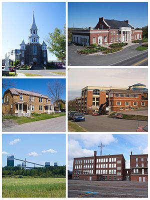
Alma, Quebec
Town in Quebec, Canada
Distance: Approx. 1390 meters
Latitude and longitude: 48.55,-71.65
Alma (2021 Town population: 30,331; CA Population 33,018; UA Population 26,016) is a town in Saguenay–Lac-Saint-Jean, in the Canadian province of Quebec.

Lac-Saint-Jean-Est Regional County Municipality
Regional county municipality in Quebec, Canada
Distance: Approx. 1390 meters
Latitude and longitude: 48.55,-71.65
Lac-Saint-Jean-Est is a regional county municipality in the Saguenay–Lac-Saint-Jean region of Quebec, Canada. The seat is Alma. In 2016, 99.3% reported that they spoke French most often at home, according to the census.
Alma Airport
Airport in Alma, Quebec, Canada
Distance: Approx. 5240 meters
Latitude and longitude: 48.50861111,-71.64138889
Alma Airport (IATA: YTF, ICAO: CYTF) is located 2.2 nautical miles (4.1 km; 2.5 mi) south of Alma, Quebec, Canada. It mainly offers private flights, but it also has storage for private jets. Other services provided by Alma Airport are refuelling of Jet A type services, service of charters of helicopters and helicopter maintenance, service of refuelling of 100 LL type by Aviatech Products, air ambulance of the Quebec Government services, road maintenance, free parking next to the airport, and private terminals.
Alma (Rivière La Grande Décharge) Water Aerodrome
Airport in Alma, Quebec
Distance: Approx. 4084 meters
Latitude and longitude: 48.56333333,-71.61583333
Alma (Rivière La Grande Décharge) Water Aerodrome (TC LID: CGD2) is located 1 nautical mile (1.9 km; 1.2 mi) northeast of Alma, Quebec, Canada and is open from the middle of April to the middle of November.

Collège d'Alma
Public college in Alma, Quebec
Distance: Approx. 1292 meters
Latitude and longitude: 48.545,-71.65472222
Collège d'Alma is a CEGEP in Alma, Quebec, Canada.
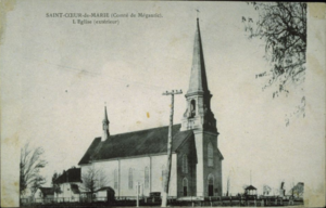
Saint-Cœur-de-Marie, Quebec
Community in Quebec, Canada
Distance: Approx. 9334 meters
Latitude and longitude: 48.63333333,-71.7
Saint-Cœur-de-Marie is a community in the Canadian province of Quebec, located in the city of Alma in the Saguenay–Lac-Saint-Jean region. The community was the birthplace of former Quebec premier Lucien Bouchard.
CFGT-FM
Radio station in Alma, Quebec
Distance: Approx. 7334 meters
Latitude and longitude: 48.59277778,-71.59027778
CFGT-FM is a French-language Canadian radio station located in Alma, Quebec. Owned and operated by Cogeco following its 2018 acquisition of most of the stations formerly owned by RNC Media, it broadcasts on 104.5 MHz with an effective radiated power of 20,000 watts, using an omnidirectional antenna (class B); it was previously heard on the AM band, on 1270 kHz, with a daytime power of 10,000 watts and a nighttime power of 5,000 watts as a class B station, using a directional antenna with slightly different daytime and nighttime directional patterns in order to protect various other stations on that frequency. The station an adult contemporary format branded as Planète 104,5.
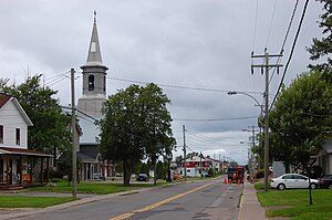
Saint-Bruno, Quebec
Municipality in Quebec, Canada
Distance: Approx. 9609 meters
Latitude and longitude: 48.46666667,-71.65
For other places named Saint-Bruno in Quebec, see Saint Bruno (disambiguation). Saint-Bruno is a municipality in Quebec, located within the regional county municipality of Lac-Saint-Jean-Est. The municipality had a population of 2,636 as of the Canada 2011 Census.

Saint-Gédéon, Quebec
Municipality in Quebec, Canada
Distance: Approx. 9269 meters
Latitude and longitude: 48.5,-71.76666667
Saint-Gédéon or Saint-Gédéon-de-Grandmont is a municipality in Quebec, Canada, in the regional county municipality of Lac-Saint-Jean-Est and the administrative region of Saguenay–Lac-Saint-Jean. It is on the eastern shore of Lac Saint-Jean at the mouth of the Belle River.

La Petite Décharge
River in Quebec, Canada
Distance: Approx. 4126 meters
Latitude and longitude: 48.538936,-71.616268
La Petite Décharge is the name of one of the two emissaries of lac Saint-Jean, the other being the La Grande Décharge. This river flows south of Alma Island, on the northwest shore of St. Lawrence River, in the town of Alma, in the Lac-Saint-Jean-Est Regional County Municipality, in the administrative region of Saguenay-Lac-Saint-Jean, in the Province of Quebec, in Canada.
Bédard River
River in Saguenay–Lac-Saint-Jean, Quebec, Canada
Distance: Approx. 3674 meters
Latitude and longitude: 48.55944,-71.71722
The Bédard River is a tributary of the Saguenay River (via la Petite Décharge), flowing in the administrative region of Saguenay–Lac-Saint-Jean, in the province of Quebec, in Canada. The course of the river successively crosses the MRC of: Le Fjord-du-Saguenay Regional County Municipality: municipality of Larouche; Lac-Saint-Jean-Est Regional County Municipality: municipalities of Hébertville-Station and Saint-Bruno, as well as the city of Alma. The Bédard River valley is served by Scott Street West, route 169 (avenue du Pont Sud), by route 170, boulevard Maurice-Paradis, chemin du 6e rang, chemin du 5e rang, chemin du 4e rang nord, chemin du rang Saint-Pierre, chemin du Petit rang Saint-Pierre.
Weather in this IP's area
few clouds
28 Celsius
29 Celsius
28 Celsius
28 Celsius
1018 hPa
60 %
1018 hPa
1008 hPa
10000 meters
3.73 m/s
9.38 m/s
238 degree
12 %
06:25:33
18:57:22