24.106.172.131 - IP Lookup: Free IP Address Lookup, Postal Code Lookup, IP Location Lookup, IP ASN, Public IP
Country:
Region:
City:
Location:
Time Zone:
Postal Code:
IP information under different IP Channel
ip-api
Country
Region
City
ASN
Time Zone
ISP
Blacklist
Proxy
Latitude
Longitude
Postal
Route
Luminati
Country
Region
nc
City
waxhaw
ASN
Time Zone
America/New_York
ISP
TWC-11426-CAROLINAS
Latitude
Longitude
Postal
IPinfo
Country
Region
City
ASN
Time Zone
ISP
Blacklist
Proxy
Latitude
Longitude
Postal
Route
IP2Location
24.106.172.131Country
Region
north carolina
City
waxhaw
Time Zone
America/New_York
ISP
Language
User-Agent
Latitude
Longitude
Postal
db-ip
Country
Region
City
ASN
Time Zone
ISP
Blacklist
Proxy
Latitude
Longitude
Postal
Route
ipdata
Country
Region
City
ASN
Time Zone
ISP
Blacklist
Proxy
Latitude
Longitude
Postal
Route
Popular places and events near this IP address
JAARS, North Carolina
CDP in North Carolina, United States
Distance: Approx. 6962 meters
Latitude and longitude: 34.86222222,-80.74888889
Jaars, capitalized as JAARS on some maps, is a census-designated place (CDP) in Union County, North Carolina, United States. The population was 597 at the 2010 census. The region's name comes from JAARS, a non-profit organization that is located there.
Mineral Springs, North Carolina
Town in North Carolina, United States
Distance: Approx. 5662 meters
Latitude and longitude: 34.94111111,-80.68472222
Mineral Springs is a town in Union County, North Carolina, United States. The population was 2,639 at the 2010 census.

Waxhaw, North Carolina
Town in North Carolina, United States
Distance: Approx. 1313 meters
Latitude and longitude: 34.93638889,-80.74388889
Waxhaw is a town in Union County, North Carolina, United States. The population was 20,534 according to the 2020 Census. The population grew 108.28% from 2010.
Waxhaws
Area on the border of North and South Carolina, USA
Distance: Approx. 270 meters
Latitude and longitude: 34.9259,-80.7459
The Waxhaws is a geographical region extending beyond both sides of the border between what now is North Carolina and South Carolina, United States. It encompasses the areas currently known as Lancaster, Union and Mecklenburg counties. The name is derived from that of the Indigenous people who first inhabited the landbase, the Waxhaw people.
WOLS
Radio station in Waxhaw–Charlotte, North Carolina
Distance: Approx. 6398 meters
Latitude and longitude: 34.884,-80.793
WOLS (106.1 MHz) is a Regional Mexican radio station, owned by Norsan Media. Licensed to Waxhaw, North Carolina, the station identifies itself as “La Raza 106.1”. The station’s studios are located in Charlotte, North Carolina, and the transmitter is located in Catawba, South Carolina.
Battle of Wahab's Plantation
1780 battle of the American Revolutionary War
Distance: Approx. 7312 meters
Latitude and longitude: 34.86084,-80.76265
The Battle of Wahab's Plantation was a surprise attack on a Loyalist camp, which included elements of the British Legion commanded by Banastre Tarleton (although at the time of the battle Tarleton had yellow fever and was not in command), by Patriot militia under the command of William R. Davie on September 21, 1780. The owner of the plantation was militia Captain James A. Walkup who served as a guide for Davie prior to the attack. Confusion has arisen over the spelling of the name Wahab as there are many spellings of the surname including, Walkup/Wahab/Wauchope/Waughup.
Cuthbertson High School
American public school in North Carolina
Distance: Approx. 5625 meters
Latitude and longitude: 34.975,-80.739
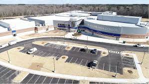
Cuthbertson High School is a moderately sized high school in Waxhaw, North Carolina a part of Union County Public Schools. It was founded in August, 2009 under the administration of the then principal, Robert Jackson. The school was founded by pulling students from other area high schools including Parkwood High School, Marvin Ridge High School and Weddington High School.

Waxhaw Historic District
Historic district in North Carolina, United States
Distance: Approx. 130 meters
Latitude and longitude: 34.92361111,-80.74416667
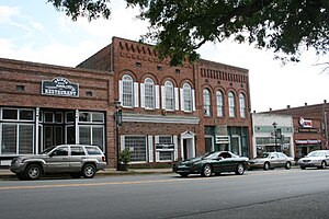
The Waxhaw Historic District is a national historic district located at Waxhaw, Union County, North Carolina. It encompasses 93 contributing buildings, 3 contributing structures, and 1 contributing object in the central business district and surrounding residential sections of Waxhaw. The district developed between about 1888 and 1940 and includes notable examples of Commercial Style, Queen Anne, and Bungalow / American Craftsman style architecture.

Pleasant Grove Camp Meeting Ground
Historic district in North Carolina, United States
Distance: Approx. 6270 meters
Latitude and longitude: 34.955,-80.68555556
The Pleasant Grove Camp Meeting Ground is a historic Methodist camp meeting national historic district located near Waxhaw, Union County, North Carolina. The district encompasses four contributing buildings and one contributing site. The main building is the arbor that dates to 1830.

Jackson Township, Union County, North Carolina
Township in North Carolina, United States
Distance: Approx. 5657 meters
Latitude and longitude: 34.87682,-80.72229
Jackson Township, population 11,012, is one of nine townships in Union County, North Carolina. Jackson Township is 59.14 square miles (153.2 km2) in size and is located in southwest Union County.

Sandy Ridge Township, Union County, North Carolina
Township in North Carolina, United States
Distance: Approx. 6961 meters
Latitude and longitude: 34.98565,-80.7269
Sandy Ridge Township, population 45,672, is one of nine townships in Union County, North Carolina. Sandy Ridge Township is 65.69 square miles (170.1 km2) in size and is located in southwestern Union County. This township contains the town of Weddington, as well as portions of the towns of Waxhaw, Mineral Springs, and Stallings.

Indian Land High School
High school in Lancaster, Lancaster County, South Carolina, United States
Distance: Approx. 6032 meters
Latitude and longitude: 34.893787,-80.797749
Indian Land High School (ILHS) is a public high school in "the Panhandle" of Lancaster County, South Carolina, United States. It is one of four high schools in Lancaster County School District.
Weather in this IP's area
moderate rain
3 Celsius
-0 Celsius
2 Celsius
3 Celsius
1005 hPa
93 %
1005 hPa
982 hPa
4023 meters
3.6 m/s
10 degree
100 %