Country:
Region:
City:
Latitude and Longitude:
Time Zone:
Postal Code:
IP information under different IP Channel
ip-api
Country
Region
City
ASN
Time Zone
ISP
Blacklist
Proxy
Latitude
Longitude
Postal
Route
Luminati
Country
ASN
Time Zone
America/Chicago
ISP
ADP1
Latitude
Longitude
Postal
IPinfo
Country
Region
City
ASN
Time Zone
ISP
Blacklist
Proxy
Latitude
Longitude
Postal
Route
db-ip
Country
Region
City
ASN
Time Zone
ISP
Blacklist
Proxy
Latitude
Longitude
Postal
Route
ipdata
Country
Region
City
ASN
Time Zone
ISP
Blacklist
Proxy
Latitude
Longitude
Postal
Route
Popular places and events near this IP address

Maverik Center
Multi-purpose indoor arena in West Valley City, Utah, U.S.
Distance: Approx. 836 meters
Latitude and longitude: 40.70272222,-111.95041667
The Maverik Center, originally known as the E Center, is a 12,600-seat multi-purpose indoor arena located in West Valley City, Utah, United States. Construction on the arena started in 1996 and was completed in time to hold its first event on September 22, 1997. The arena is owned by West Valley City, and managed by Centennial Management Group.
Unified Fire Authority
Distance: Approx. 2423 meters
Latitude and longitude: 40.697,-111.918
The Unified Fire Authority of Greater Salt Lake provides fire protection and emergency medical services for the unincorporated Salt Lake County, Utah as well as for 9 cities located within the Salt Lake Metropolitan Area. These cities include Alta, Cottonwood Heights, Eagle Mountain, Herriman, Holladay, Midvale, Riverton and Taylorsville.
Valley Fair Mall (Utah)
Shopping mall in West Valley City, Utah
Distance: Approx. 1817 meters
Latitude and longitude: 40.69444444,-111.95555556
Valley Fair Mall is a 831,667-square-foot (77,264.4 m2) single-level regional shopping center located in West Valley City, Utah, United States. Anchor stores are All Star Bowling & Entertainment, Hobby Lobby, JCPenney, Megaplex Theatres, Old Navy, Ross Dress For Less, and Ulta Beauty.

Usana Health Sciences
American direct-selling company
Distance: Approx. 3176 meters
Latitude and longitude: 40.711563,-111.980288
Usana Health Sciences, Inc., or USANA, is an American direct-selling company based in West Valley City, Utah. As of 2021, Usana was the 14th largest direct-selling company in the world by revenue. The company manufactures most of its nutritional products, dietary supplements, and skincare products at a West Valley City facility.

KKAT (AM)
Radio station in Salt Lake City, Utah
Distance: Approx. 1147 meters
Latitude and longitude: 40.71305556,-111.93138889
KKAT (860 kHz) is an AM radio station broadcasting a talk radio format. KKAT is licensed to Salt Lake City, Utah and is owned by Cumulus Media. The station's studios are located in South Salt Lake (behind the I-15/I-80 interchange).
West Lake Junior High
Public jr. high school in West Valley City, Salt Lake County, Utah, USA
Distance: Approx. 2819 meters
Latitude and longitude: 40.69916667,-111.97444444
West Lake STEM Junior High or WLJH is a public junior high in West Valley City, Utah. It is located at 3400 South and 3450 West in the Granger region of West Valley City. The school belongs to the very large Granite School District, which covers a large portion of the Salt Lake Valley in Utah.

River Trail station
Light rail station in West Valley City, Utah, United States
Distance: Approx. 2246 meters
Latitude and longitude: 40.721693,-111.923816
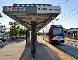
River Trail station is a light rail station in West Valley City, Utah, in the United States, served by the Green Line of the Utah Transit Authority's (UTA) TRAX light rail system. The Green Line provides service from the Salt Lake City International Airport to West Valley City (via Downtown Salt Lake City).

Redwood Junction station
Light rail station in West Valley City, Utah, United States
Distance: Approx. 438 meters
Latitude and longitude: 40.711091,-111.940362
Redwood Junction station is a light rail station in West Valley City, Utah, United States, served by the Green Line of the Utah Transit Authority's (UTA) TRAX light rail system. The Green Line provides service from the Salt Lake International Airport to West Valley City (via Downtown Salt Lake City).

West Valley Central station
Light rail station in Utah
Distance: Approx. 2010 meters
Latitude and longitude: 40.6944,-111.9591
West Valley Central station (also called the West Valley Intermodal Hub) is a light rail station in West Valley City, Utah served by the Green Line of the Utah Transit Authority's (UTA) TRAX light rail system. The Green Line provides service from the Salt Lake City International Airport to this station (via Downtown Salt Lake City).

Decker Lake station
Light rail station in West Valley, Utah, United States
Distance: Approx. 588 meters
Latitude and longitude: 40.704656,-111.948688
Decker Lake station is a light rail station in West Valley City, Utah, served by the Green Line of the Utah Transit Authority's (UTA) TRAX light rail system. The Green Line provides service from the Salt Lake International Airport to West Valley City (via Downtown Salt Lake City).
Uinta Brewing Company
Craft brewery in Salt Lake City, Utah
Distance: Approx. 2946 meters
Latitude and longitude: 40.73277778,-111.95416667
Uinta Brewing Company is a craft brewery founded in 1993 in Salt Lake City, Utah, USA. The company produces a range of beers, naming them after Utah's cultural and natural icons. As of 2016, Uinta was the 39th-largest craft brewery in the country.
Granger-Hunter, Utah
Former CDP in Utah, United States
Distance: Approx. 3007 meters
Latitude and longitude: 40.70666667,-111.97861111
Granger-Hunter was a census-designated place in Salt Lake County, Utah, USA, during the 1970 United States Census. which comprises the communities of Granger and Hunter. The population in 1970 was 9,029.
Weather in this IP's area
light rain
4 Celsius
-3 Celsius
2 Celsius
5 Celsius
1014 hPa
72 %
1014 hPa
866 hPa
10000 meters
13.38 m/s
15.43 m/s
310 degree
100 %
07:18:55
17:07:33