Country:
 USA
USARegion:
City:
Latitude and Longitude:
Time Zone:
Postal Code:
IP information under different IP Channel
ip-api
Country
Region
City
ASN
Time Zone
ISP
Blacklist
Proxy
Latitude
Longitude
Postal
Route
IPinfo
Country
Region
City
ASN
Time Zone
ISP
Blacklist
Proxy
Latitude
Longitude
Postal
Route
MaxMind
Country
Region
City
ASN
Time Zone
ISP
Blacklist
Proxy
Latitude
Longitude
Postal
Route
Luminati
Country
USRegion
ca
City
berkeley
ASN
Time Zone
America/Los_Angeles
ISP
AS-SONICTELECOM
Latitude
Longitude
Postal
db-ip
Country
Region
City
ASN
Time Zone
ISP
Blacklist
Proxy
Latitude
Longitude
Postal
Route
ipdata
Country
Region
City
ASN
Time Zone
ISP
Blacklist
Proxy
Latitude
Longitude
Postal
Route
Popular places and events near this IP address
Zaytuna College
Muslim liberal arts college in Berkeley, California
Distance: Approx. 1327 meters
Latitude and longitude: 37.89744444,-122.25933333
Zaytuna College is a private liberal arts college in Berkeley, California. It is the first accredited Muslim undergraduate college in the United States. It was built on the foundation of an educational institute, founded in 1996 by Hamza Yusuf and Hesham Alalusi.

Indian Rock Park
A park and rock formation in Berkeley, California, USA
Distance: Approx. 14 meters
Latitude and longitude: 37.89222222,-122.27305556
Indian Rock Park is a 1.18-acre (4,800 m2) public park in the city of Berkeley, California, on the slope of the Berkeley Hills. Located in the northeast part of the city, it is about two blocks north of the Arlington/Marin Circle, and straddles Indian Rock Avenue. The central feature of the park is a large rock outcropping on the west side of Indian Rock Ave.
Cragmont, Berkeley, California
Neighborhood of Berkeley in Alameda, California, United States
Distance: Approx. 774 meters
Latitude and longitude: 37.89527778,-122.265
The Cragmont area of Berkeley is a residential district located in the northeastern section of the city, occupying most of the hill area north of Codornices Creek. It lies at an elevation of 755 feet (230 m). The Cragmont area was mostly grassland with oak and bay laurel trees in the canyons until the beginnings of the American era.
Thousand Oaks, Berkeley, California
Neighborhood in Berkeley, California, USA
Distance: Approx. 686 meters
Latitude and longitude: 37.89555556,-122.27944444
Thousand Oaks is a neighborhood of Berkeley in Alameda County, California. Located at the base of the Berkeley Hills, it lies at an elevation of 239 feet (73 m). The principal shopping area is Solano Avenue, along the southern edge of the neighborhood.
Edible Schoolyard
School in California, United States of America
Distance: Approx. 1116 meters
Latitude and longitude: 37.8825,-122.27611111
The Edible Schoolyard (ESY) is a 1-acre (4,000 m2) garden and kitchen program at the Martin Luther King Jr. Middle School, a public middle school in Berkeley, California. It was established in 1995 by chef and author Alice Waters.
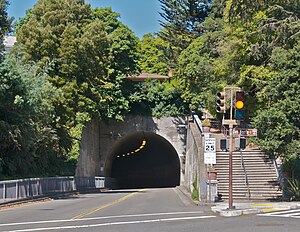
Northbrae Tunnel
Road tunnel in Berkeley, California, US
Distance: Approx. 212 meters
Latitude and longitude: 37.8903,-122.2728
The Northbrae Tunnel, also referred to as the Solano Avenue Tunnel, was built as a commuter electric railroad tunnel in the northern part of Berkeley, California, and was later converted to street use. In 1910 the Southern Pacific Railroad (SP) was electrifying its steam-engine drawn ferry-train line (to San Francisco) from Oakland Pier via Shattuck Avenue to Vine Street in Berkeley and extending it north along the base of the Berkeley Hills to newly developing neighborhoods of Berkeley at Northbrae and Thousand Oaks. The route chosen was Henry Street and Sutter Street to its intersection with Hopkins.

Donald and Helen Olsen House
Historic house in California, United States
Distance: Approx. 437 meters
Latitude and longitude: 37.89611111,-122.2725
The Donald and Helen Olsen House, in Berkeley, California, was built in 1954. It is a Modernist, International-style house designed by architect Donald Olsen. Olsen is a native of Minnesota who studied under Walter Gropius at Harvard and established an architecture practice in Berkeley in 1953.

Northbrae, Berkeley, California
Neighborhood in Berkeley, California, USA
Distance: Approx. 238 meters
Latitude and longitude: 37.8901,-122.2724
Northbrae is a neighborhood in Berkeley, California built as part of the northern expansion of North Berkeley. Its technical border is Solano Avenue to the North, Spruce Street to the East, the Albany city limits to the West, and Hopkins Street, Yolo Avenue, and Eunice Street to the south. Northbrae however broadly refers to the upper half of North Berkeley starting at or around Rose Street but ending before Solano.
John Hopkins Spring Estate
Distance: Approx. 735 meters
Latitude and longitude: 37.8985,-122.2754
The John Hopkins Spring Estate is a large estate in Berkeley, California. The associated Spring Mansion was built in the 1910s by East Bay developer John Hopkins Spring and designed by architect John Hudson Thomas. It later became the site of a school founded by educator Cora Lenore Williams.
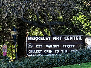
Berkeley Art Center
Community art center and gallery
Distance: Approx. 877 meters
Latitude and longitude: 37.885242,-122.268225
Berkeley Art Center (BAC) is a nonprofit arts organization, community art space, and gallery founded in 1967 and located at 1275 Walnut Street in Live Oak Park, Berkeley, California.

Garfield Intermediate School
Historic place in Berkeley, California
Distance: Approx. 1236 meters
Latitude and longitude: 37.881592,-122.268733
Garfield Intermediate School, also for sometime the Garfield Junior High School, now the Berkeley Jewish Community Center, East Bay is a historical building in Berkeley, California. The Garfield Intermediate School was built in 1915. The one-story Garfield Intermediate School building was listed on the National Register of Historic Places on June 14, 1982.
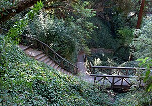
John Hinkel Park
Historic site
Distance: Approx. 345 meters
Latitude and longitude: 37.895278,-122.273333
John Hinkel Park is an urban park located in the North Berkeley neighborhood of Berkeley, California, U.S.. It has been listed by the city as a Berkeley Landmark since April 2, 2001, and it contains a historical plaque since 2003.
Weather in this IP's area
few clouds
20 Celsius
20 Celsius
17 Celsius
26 Celsius
1011 hPa
71 %
1011 hPa
997 hPa
10000 meters
5.14 m/s
310 degree
20 %
06:54:49
19:10:36