Country:
 USA
USARegion:
City:
Latitude and Longitude:
Time Zone:
Postal Code:
IP information under different IP Channel
ip-api
Country
Region
City
ASN
Time Zone
ISP
Blacklist
Proxy
Latitude
Longitude
Postal
Route
IPinfo
Country
Region
City
ASN
Time Zone
ISP
Blacklist
Proxy
Latitude
Longitude
Postal
Route
MaxMind
Country
Region
City
ASN
Time Zone
ISP
Blacklist
Proxy
Latitude
Longitude
Postal
Route
Luminati
Country
USRegion
ca
City
southsanfrancisco
ASN
Time Zone
America/Los_Angeles
ISP
AS-SONICTELECOM
Latitude
Longitude
Postal
db-ip
Country
Region
City
ASN
Time Zone
ISP
Blacklist
Proxy
Latitude
Longitude
Postal
Route
ipdata
Country
Region
City
ASN
Time Zone
ISP
Blacklist
Proxy
Latitude
Longitude
Postal
Route
Popular places and events near this IP address

South San Francisco, California
City in California, United States
Distance: Approx. 902 meters
Latitude and longitude: 37.65,-122.41666667
South San Francisco is a city in San Mateo County, California, United States, on the San Francisco Peninsula in the San Francisco Bay Area. Its location has been populated for more than five thousand years. The city is colloquially termed "South City".

Golden Gate National Cemetery
Veterans cemetery in San Mateo County, California
Distance: Approx. 2116 meters
Latitude and longitude: 37.63527778,-122.43111111
Golden Gate National Cemetery is a United States national cemetery in California, located in the city of San Bruno, 12 miles (20 km) south of San Francisco. Because of the name and location, it is frequently confused with San Francisco National Cemetery, which dates to the 19th century and is in the Presidio of San Francisco, in view of the Golden Gate. Around 1937, San Francisco residents voted to bar the opening of new cemeteries within the city proper and, as a result, the site for the new national cemetery was selected south of the city limits in adjacent San Mateo County.

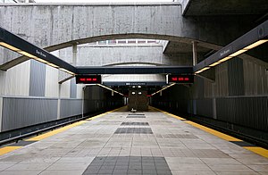
South San Francisco station (BART)
Rapid transit station in San Francisco Bay Area
Distance: Approx. 1985 meters
Latitude and longitude: 37.6642,-122.444
South San Francisco station is a Bay Area Rapid Transit (BART) station located in South San Francisco, California in northern San Mateo County. It consists of two main tracks and a shared underground island platform. The station is served by the Red and Yellow lines.
San Bruno station (BART)
Rapid transit station in San Francisco Bay Area
Distance: Approx. 1907 meters
Latitude and longitude: 37.6383,-122.4165
San Bruno station is a Bay Area Rapid Transit (BART) station located adjacent to the Tanforan shopping center in San Bruno, California in northern San Mateo County. It consists of two main tracks and a shared underground island platform. Service at the station began on June 22, 2003 as part of the BART San Mateo County Extension project that extended BART service southward from Colma to Millbrae and San Francisco International Airport.

The Shops at Tanforan
Regional shopping mall in the United States
Distance: Approx. 2095 meters
Latitude and longitude: 37.636,-122.418
The Shops at Tanforan is a regional shopping mall in San Bruno, California, United States. It is located on the San Francisco Peninsula, 10 miles (16 km) south of San Francisco city limits. The site was originally used as a horse racing track from 1899 until 1964, when the grandstand was destroyed by fire.

South San Francisco High School
Public high school in South San Francisco, California, United States
Distance: Approx. 667 meters
Latitude and longitude: 37.647828,-122.426287
South San Francisco High School (known colloquially as South City High) is a 9-12 public high school in South San Francisco, California, United States and is part of the South San Francisco Unified School District (SSFUSD). Vision Statement: South San Francisco High School will graduate resilient, empathetic, lifelong learners who will become productive, globally conscious citizens with useful skills to contribute to an ever changing society.

South San Francisco Public Library
Distance: Approx. 976 meters
Latitude and longitude: 37.6524342,-122.4366394
The South San Francisco Public Library is located in South San Francisco, California. It is an independent city library and part of the Peninsula Library System, a consortium of city, county, and community college libraries in San Mateo County. The library holds approximately 166,000 volumes and has 29,000 borrowers.
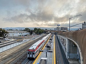
South San Francisco station (Caltrain)
Train station in South San Francisco, California, U.S.
Distance: Approx. 1744 meters
Latitude and longitude: 37.655,-122.40597222
South San Francisco station is a Caltrain station in South San Francisco, California. The station is on the east side of the Bayshore Freeway (U.S. 101), east and south of the curved Grand Avenue overpass, and north of where the freeway crosses over the tracks. Downtown South San Francisco is to the west, across the freeway.

Tanforan Racetrack
Distance: Approx. 2127 meters
Latitude and longitude: 37.6354361,-122.4190361
Tanforan Racetrack, also known as Tanforan Park, was a thoroughbred horse racing facility in San Bruno on the San Francisco Peninsula in California. It operated from November 4, 1899 to 1964. The horse racing track and buildings were constructed to serve a clientele from nearby San Francisco.
Baden High School
Public continuation high school in the United States
Distance: Approx. 1019 meters
Latitude and longitude: 37.649999,-122.436222
Baden High School is a public continuation high school in the city of South San Francisco, California. The school is part of the South San Francisco Unified School District. The school is named for the Baden neighborhood of South San Francisco, formerly the town of Baden before South San Francisco was incorporated.

South San Francisco hillside sign
United States historic place
Distance: Approx. 1036 meters
Latitude and longitude: 37.6614238,-122.4189591
The South San Francisco Hillside Sign is a historic sign on a hillside overlooking the city of South San Francisco in San Mateo County, California. It was created in the 1920s and was listed on the National Register of Historic Places in 1996. The sign is the main feature of Sign Hill Park, a city park which provides 30 acres (12 ha) of open space, almost 2 miles (3.2 km) of hiking trails, and access to the letters of the sign itself.

Tanforan Assembly Center
Place in California, United States
Distance: Approx. 2127 meters
Latitude and longitude: 37.6354361,-122.4190361
The Tanforan Assembly Center was created to temporarily detain nearly 8,000 Japanese Americans, mostly from the San Francisco Bay Area, under the auspices of Executive Order 9066. After the order was signed in February 1942, the Wartime Civil Control Administration acquired Tanforan Racetrack on April 4 for use as a temporary assembly center; plans called for the site to be used to accommodate up to 10,000 "evacuees" while permanent relocation sites were being prepared further inland. The Tanforan Assembly Center began operation in late April 1942, the first stop for thousands who were forced to relocate and undergo internment during World War II. The majority were U.S. citizens of Japanese ancestry who were born in the United States.
Weather in this IP's area
scattered clouds
19 Celsius
19 Celsius
17 Celsius
24 Celsius
1011 hPa
76 %
1011 hPa
1011 hPa
10000 meters
6.17 m/s
310 degree
40 %
06:55:29
19:11:10