Country:
Region:
City:
Latitude and Longitude:
Time Zone:
Postal Code:
IP information under different IP Channel
ip-api
Country
Region
City
ASN
Time Zone
ISP
Blacklist
Proxy
Latitude
Longitude
Postal
Route
Luminati
Country
Region
ca
City
oakland
ASN
Time Zone
America/Los_Angeles
ISP
AS-SONICTELECOM
Latitude
Longitude
Postal
IPinfo
Country
Region
City
ASN
Time Zone
ISP
Blacklist
Proxy
Latitude
Longitude
Postal
Route
db-ip
Country
Region
City
ASN
Time Zone
ISP
Blacklist
Proxy
Latitude
Longitude
Postal
Route
ipdata
Country
Region
City
ASN
Time Zone
ISP
Blacklist
Proxy
Latitude
Longitude
Postal
Route
Popular places and events near this IP address

Tilden Park Merry-Go-Round
United States historic place
Distance: Approx. 1167 meters
Latitude and longitude: 37.900543,-122.256074
The Tilden Park Merry-Go-Round is a menagerie carousel located in Tilden Regional Park near Berkeley and Oakland, in unincorporated Contra Costa County. It was built by the Herschell-Spillman Company of Tonawanda, New York in 1911, and it is one of the few antique carousels left in the United States. Before arriving at Tilden in 1948, the carousel had seen service at amusement parks in San Bernardino, Ocean Beach, and Los Angeles.
Zaytuna College
Muslim liberal arts college in Berkeley, California
Distance: Approx. 722 meters
Latitude and longitude: 37.89744444,-122.25933333
Zaytuna College is a private liberal arts college in Berkeley, California. It is the first accredited Muslim undergraduate college in the United States. It was built on the foundation of an educational institute, founded in 1996 by Hamza Yusuf and Hesham Alalusi.

Indian Rock Park
A park and rock formation in Berkeley, California, USA
Distance: Approx. 831 meters
Latitude and longitude: 37.89222222,-122.27305556
Indian Rock Park is a 1.18-acre (4,800 m2) public park in the city of Berkeley, California, on the slope of the Berkeley Hills. Located in the northeast part of the city, it is about two blocks north of the Arlington/Marin Circle, and straddles Indian Rock Avenue. The central feature of the park is a large rock outcropping on the west side of Indian Rock Ave.

La Loma Park
Neighborhood of Berkeley, California, United States of America
Distance: Approx. 1163 meters
Latitude and longitude: 37.88222222,-122.25861111
La Loma Park is a neighborhood and tract of land located in the Berkeley Hills section of the city of Berkeley, California in the San Francisco Bay Area. The land had been the property of Captain Richard Parks Thomas, a veteran of the American Civil War and Berkeley businessman. Today, it is entirely a residential area The Spanish word loma means "rise/low hill".
Cragmont, Berkeley, California
Neighborhood of Berkeley in Alameda, California, United States
Distance: Approx. 396 meters
Latitude and longitude: 37.89527778,-122.265
The Cragmont area of Berkeley is a residential district located in the northeastern section of the city, occupying most of the hill area north of Codornices Creek. It lies at an elevation of 755 feet (230 m). The Cragmont area was mostly grassland with oak and bay laurel trees in the canyons until the beginnings of the American era.

1923 Berkeley, California, fire
Conflagration that consumed 640 structures
Distance: Approx. 1213 meters
Latitude and longitude: 37.89,-122.25
The 1923 Berkeley, California, fire was a conflagration that consumed some 640 structures, including 584 houses in the densely built neighborhoods north of the campus of the University of California in Berkeley, California, on September 17, 1923.

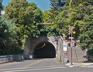
Northbrae Tunnel
Road tunnel in Berkeley, California, US
Distance: Approx. 828 meters
Latitude and longitude: 37.8903,-122.2728
The Northbrae Tunnel, also referred to as the Solano Avenue Tunnel, was built as a commuter electric railroad tunnel in the northern part of Berkeley, California, and was later converted to street use. In 1910 the Southern Pacific Railroad (SP) was electrifying its steam-engine drawn ferry-train line (to San Francisco) from Oakland Pier via Shattuck Avenue to Vine Street in Berkeley and extending it north along the base of the Berkeley Hills to newly developing neighborhoods of Berkeley at Northbrae and Thousand Oaks. The route chosen was Henry Street and Sutter Street to its intersection with Hopkins.

Donald and Helen Olsen House
Historic house in California, United States
Distance: Approx. 912 meters
Latitude and longitude: 37.89611111,-122.2725
The Donald and Helen Olsen House, in Berkeley, California, was built in 1954. It is a Modernist, International-style house designed by architect Donald Olsen. Olsen is a native of Minnesota who studied under Walter Gropius at Harvard and established an architecture practice in Berkeley in 1953.

Northbrae, Berkeley, California
Neighborhood in Berkeley, California, USA
Distance: Approx. 799 meters
Latitude and longitude: 37.8901,-122.2724
Northbrae is a neighborhood in Berkeley, California built as part of the northern expansion of North Berkeley. Its technical border is Solano Avenue to the North, Spruce Street to the East, the Albany city limits to the West, and Hopkins Street, Yolo Avenue, and Eunice Street to the south. Northbrae however broadly refers to the upper half of North Berkeley starting at or around Rose Street but ending before Solano.

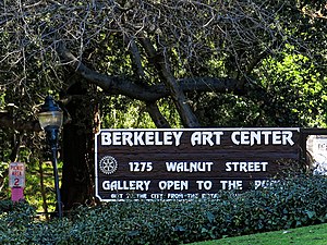
Berkeley Art Center
Community art center and gallery
Distance: Approx. 845 meters
Latitude and longitude: 37.885242,-122.268225
Berkeley Art Center (BAC) is a nonprofit arts organization, community art space, and gallery founded in 1967 and located at 1275 Walnut Street in Live Oak Park, Berkeley, California.

Rose Walk (Berkeley, California)
Historic site in Berkeley, California, U.S.
Distance: Approx. 994 meters
Latitude and longitude: 37.883115,-122.261546
The Rose Walk, formerly known as Rose Street, is a historic pathway with landscaping designed by architect Bernard Maybeck in the La Loma Park neighborhood of Berkeley, California, U.S.. It is located in the 2500 block of Rose Walk, between Euclid Avenue and Le Roy Avenue. It is listed by the city as a Berkeley Landmark, since December 15, 1975.

John Hinkel Park
Historic site
Distance: Approx. 934 meters
Latitude and longitude: 37.895278,-122.273333
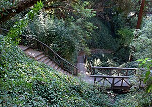
John Hinkel Park is an urban park located in the North Berkeley neighborhood of Berkeley, California, U.S.. It has been listed by the city as a Berkeley Landmark since April 2, 2001, and it contains a historical plaque since 2003.
Weather in this IP's area
broken clouds
14 Celsius
13 Celsius
13 Celsius
16 Celsius
1021 hPa
65 %
1021 hPa
994 hPa
10000 meters
3.6 m/s
300 degree
75 %
06:47:03
16:59:42