Country:
 USA
USARegion:
City:
Latitude and Longitude:
Time Zone:
Postal Code:
IP information under different IP Channel
ip-api
Country
Region
City
ASN
Time Zone
ISP
Blacklist
Proxy
Latitude
Longitude
Postal
Route
IPinfo
Country
Region
City
ASN
Time Zone
ISP
Blacklist
Proxy
Latitude
Longitude
Postal
Route
MaxMind
Country
Region
City
ASN
Time Zone
ISP
Blacklist
Proxy
Latitude
Longitude
Postal
Route
Luminati
Country
USASN
Time Zone
America/Chicago
ISP
INTERNAP-2BLK
Latitude
Longitude
Postal
db-ip
Country
Region
City
ASN
Time Zone
ISP
Blacklist
Proxy
Latitude
Longitude
Postal
Route
ipdata
Country
Region
City
ASN
Time Zone
ISP
Blacklist
Proxy
Latitude
Longitude
Postal
Route
Popular places and events near this IP address

Waldon, California
Former Census-designated place in California, United States
Distance: Approx. 1994 meters
Latitude and longitude: 37.92638889,-122.05555556
Waldon is a former census-designated place (CDP) in Contra Costa County, California, United States. The population was 5,133 at the 2000 census. It is served by Pleasant Hill/Contra Costa Centre station on the Bay Area Rapid Transit (BART) Yellow Line, and by Interstate 680.

Walnut Creek, California
City in California, United States
Distance: Approx. 413 meters
Latitude and longitude: 37.90638889,-122.065
Walnut Creek is a city in Contra Costa County, California, United States, located in the East Bay region of the San Francisco Bay Area, about 16 miles (26 kilometers) east of the city of Oakland. Walnut Creek has a total population of 70,127 per the 2020 census, is located at the junction of the highways from Sacramento and San Jose (I-680) and San Francisco/Oakland (SR-24), and is accessible by BART. The city shares its borders with Clayton, Lafayette, Alamo, Pleasant Hill, and Concord.

Gardens at Heather Farm
Distance: Approx. 2183 meters
Latitude and longitude: 37.91888889,-122.04277778
The 6-acre (2.4 ha) Gardens at Heather Farm are a set of gardens located at Heather Farm Park in Walnut Creek, California, United States. The gardens have a view of Mount Diablo, and are open to the public 7 days a week during daylight hours.
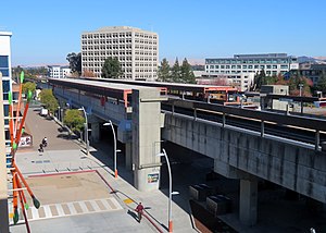
Walnut Creek station
Rapid transit station in San Francisco Bay Area
Distance: Approx. 528 meters
Latitude and longitude: 37.905724,-122.067332
Walnut Creek station is an elevated Bay Area Rapid Transit (BART) station in Walnut Creek, California, served by the Yellow Line. The station is located north of downtown Walnut Creek, adjacent to Interstate 680 and near the Ygnacio Valley Road and California Boulevard arterial roads.

Pleasant Hill/Contra Costa Centre station
Rapid transit station in California, US
Distance: Approx. 2185 meters
Latitude and longitude: 37.928399,-122.055992
Pleasant Hill/Contra Costa Centre station is a Bay Area Rapid Transit (BART) station serving the Contra Costa Centre Transit Village in Contra Costa Centre, California, just north of Walnut Creek and just east of Pleasant Hill. It is served by the Yellow Line.

Lindsay Wildlife Experience
Distance: Approx. 1763 meters
Latitude and longitude: 37.9235,-122.0757
Lindsay Wildlife Experience, formerly known as Lindsay Wildlife Museum, is a family museum and wildlife rehabilitation center in Walnut Creek, California. Lindsay is the first wildlife hospital established in the United States, and a popular family museum in the East Bay Area near San Francisco. Founded in Walnut Creek in 1955, the museum's programs "connect people with wildlife to inspire responsibility and respect for the world we share." The museum features a number of California wildlife exhibits, natural history specimens, and a special theater offering a look into one of the hospital's many wildlife treatment rooms.
Acalanes Ridge, California
Census-designated place in California, United States
Distance: Approx. 1337 meters
Latitude and longitude: 37.90472222,-122.07861111
Acalanes Ridge is a census-designated place in Contra Costa County, California. Acalanes Ridge sits at an elevation of 499 feet (152 m). The population was 1,285 at the 2020 Census.

Contra Costa Centre, California
Census-designated place in California, United States
Distance: Approx. 2032 meters
Latitude and longitude: 37.92611111,-122.05388889
Contra Costa Centre is an unincorporated community and census-designated place in Contra Costa County, California. Contra Costa Centre sits at an elevation of 92 feet (28 m). The 2010 United States census reported Contra Costa Centre's population was 5,364, while the 2020 census figure was 6,808.
Mount Diablo Unitarian Universalist Church
Church in CA, USA
Distance: Approx. 2050 meters
Latitude and longitude: 37.89968,-122.04575
Mount Diablo Unitarian Universalist Church (MDUUC) is a church in Walnut Creek, California. In 2016, it claimed a membership of 494. The church buildings occupy a 14-acre tract at 55 Eckley Lane in Walnut Creek.
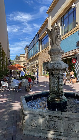
Broadway Plaza (Walnut Creek)
Shopping mall in California, United States
Distance: Approx. 1741 meters
Latitude and longitude: 37.89551,-122.05786
Broadway Plaza is an outdoor shopping mall located in downtown Walnut Creek. The shopping center opened on October 11, 1951 and is owned and operated by Macerich. The mall is anchored by Nordstrom and Macy's, and features nearly 80 stores including Crate & Barrel, flagship H&M and ZARA stores, a standalone Apple store with an adjoining outdoor plaza, an Industrious co-working space, a planned Pinstripes entertainment center and restaurant, and a planned Life Time Fitness sports club.

Las Trampas Creek
River in California, United States
Distance: Approx. 1843 meters
Latitude and longitude: 37.8941,-122.0596
Las Trampas Creek is a 12.37 mile (19.9 km) long north-east flowing stream in Contra Costa County, California. Its watershed comprises an area of 17,238 acres. Its mean daily flow is approximately 15.4 cfs.

Tice Creek
River
Distance: Approx. 1840 meters
Latitude and longitude: 37.89416667,-122.05944444
Tice Creek is a minor creek in Contra Costa County, California in the San Francisco Bay Area. It is approximately 4.1 miles (6.6 km) long. It is a tributary of Las Trampas Creek, which itself is a major tributary to Walnut Creek which in turn drains into Suisun Bay.
Weather in this IP's area
clear sky
14 Celsius
14 Celsius
11 Celsius
16 Celsius
1011 hPa
80 %
1011 hPa
1005 hPa
10000 meters
06:44:46
19:27:02