Country:
 USA
USARegion:
City:
Latitude and Longitude:
Time Zone:
Postal Code:
IP information under different IP Channel
ip-api
Country
Region
City
ASN
Time Zone
ISP
Blacklist
Proxy
Latitude
Longitude
Postal
Route
IPinfo
Country
Region
City
ASN
Time Zone
ISP
Blacklist
Proxy
Latitude
Longitude
Postal
Route
MaxMind
Country
Region
City
ASN
Time Zone
ISP
Blacklist
Proxy
Latitude
Longitude
Postal
Route
Luminati
Country
USASN
Time Zone
America/Chicago
ISP
INTERNAP-2BLK
Latitude
Longitude
Postal
db-ip
Country
Region
City
ASN
Time Zone
ISP
Blacklist
Proxy
Latitude
Longitude
Postal
Route
ipdata
Country
Region
City
ASN
Time Zone
ISP
Blacklist
Proxy
Latitude
Longitude
Postal
Route
Popular places and events near this IP address

Plymouth County, Massachusetts
County in Massachusetts, United States
Distance: Approx. 1020 meters
Latitude and longitude: 41.99,-70.74
Plymouth County is a county in the U.S. state of Massachusetts, south of Boston. As of the 2020 census, the population was 530,819. Its county seats are Plymouth and Brockton.

Kingston (CDP), Massachusetts
Census-designated place in Massachusetts, United States
Distance: Approx. 937 meters
Latitude and longitude: 41.9925,-70.71722222
Kingston is a census-designated place (CDP) in the town of Kingston in Plymouth County, Massachusetts, United States. The population was 5,591 at the 2010 census.

Kingston, Massachusetts
Town in Massachusetts, United States
Distance: Approx. 188 meters
Latitude and longitude: 41.9925,-70.7265
Kingston is a coastal town in Plymouth County, Massachusetts, United States. The population was 13,708 at the 2020 census.

South Shore (Massachusetts)
Region of Massachusetts in the United States
Distance: Approx. 1929 meters
Latitude and longitude: 42,-70.75
The South Shore of Massachusetts is a geographic region stretching south and east from Boston toward Cape Cod along the shores of Massachusetts Bay and Cape Cod Bay. It is subject to varying descriptions including municipalities in eastern Norfolk and Plymouth counties. The South Shore is an affluent area.

Kingston Collection
Shopping mall in Massachusetts, United States
Distance: Approx. 2291 meters
Latitude and longitude: 41.9762,-70.7131
Kingston Collection is a one-story enclosed shopping center and mall located in the South Shore region of Massachusetts in the United States. As of January 2022, The mall features 37 stores and restaurants. Anchors include Macy's (closing early 2025) , Target, and Regal Cinemas.

Jones River
River in the United States
Distance: Approx. 1765 meters
Latitude and longitude: 42.00083333,-70.70972222
The Jones River is a 7.5-mile-long (12.1 km) river running through Kingston, Massachusetts. The river drains about 30 square miles (78 km2), has its source in Silver Lake and drains into Kingston Bay. Land surrounding the river is 52% forested, of which 22% has been developed for residential use.
Crossman Pond
Distance: Approx. 2387 meters
Latitude and longitude: 41.98972222,-70.75694444
Crossman Pond is a 15-acre (61,000 m2) pond in Kingston, Massachusetts, located off Wapping Road (Route 106) and South Street. The pond is hydro logically associated with a cranberry bog operation located to the west of the pond. The outflow is an unnamed stream that feeds the cranberry bog, ultimately leading to Fountainhead Brook, a tributary of the Jones River.

Kingston station (Massachusetts)
Railway station in Kingston, Massachusetts, US
Distance: Approx. 1886 meters
Latitude and longitude: 41.9768,-70.7233
Kingston station (formerly Kingston/Route 3) is an MBTA Commuter Rail serving the Plymouth/Kingston Line, located off of Massachusetts Route 3 south of downtown Kingston, Massachusetts. It opened in 1997 during the restoration of Old Colony Lines service. Like all stations on the Old Colony Lines, Kingston station is fully accessible.
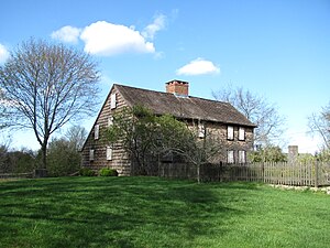
Bradford House (Kingston, Massachusetts)
Historic house in Massachusetts, United States
Distance: Approx. 685 meters
Latitude and longitude: 41.98805556,-70.72416667
The Bradford House, also known as the Major John Bradford Homestead, is a historic house at 50 Landing Road in Kingston, Massachusetts. The Jones River Village Historical Society owns the house, and operates it as a historic house museum. The oldest portion of this 2+1⁄2-story wood-frame house was built c.

Kingston Center Historic District
Historic district in Massachusetts, United States
Distance: Approx. 442 meters
Latitude and longitude: 41.995,-70.73333333
The Kingston Center Historic District is a historic district encompassing the center of Kingston, Massachusetts. The district is about 30 acres (12 ha) in size, and extends along Main Street (Massachusetts Route 106) between the First Parish Unitarian Church and the Mayflower Congregational Church, and for a short way along Green Street to the Evergreen Cemetery. At its center is the Training Green (established 1720) and Kingston Town Hall.

Frederic C. Adams Public Library
United States historic place
Distance: Approx. 308 meters
Latitude and longitude: 41.99583333,-70.73
The Frederic C. Adams Public Library is a historic library building at 33 Summer Street in Kingston, Massachusetts. Designed by Joseph Everett Chandler (1864–1945), a major proponent of the Colonial Revival style, the library was built in 1898 and added to the National Register of Historic Places in 2001. The building ceased operation as a public library in December 1994, when the town opened the new Kingston Public Library at 6 Green Street.

William Sever House
Historic house in Massachusetts, United States
Distance: Approx. 281 meters
Latitude and longitude: 41.9925,-70.72527778
The William Sever House is an historic house at 2 Linden Street in Kingston, Massachusetts. Built in 1768, it is a good local example of Georgian and Federal period architecture. Its builder, William Sever, was a prominent local political figure and businessman, serving in the colonial legislature for many years.
Weather in this IP's area
clear sky
8 Celsius
8 Celsius
6 Celsius
10 Celsius
1032 hPa
85 %
1032 hPa
1031 hPa
10000 meters
06:59:09
17:56:27