Country:
Region:
City:
Latitude and Longitude:
Time Zone:
Postal Code:
IP information under different IP Channel
ip-api
Country
Region
City
ASN
Time Zone
ISP
Blacklist
Proxy
Latitude
Longitude
Postal
Route
Luminati
Country
Region
by
City
gunzenhausen
ASN
Time Zone
Europe/Berlin
ISP
Hetzner Online GmbH
Latitude
Longitude
Postal
IPinfo
Country
Region
City
ASN
Time Zone
ISP
Blacklist
Proxy
Latitude
Longitude
Postal
Route
db-ip
Country
Region
City
ASN
Time Zone
ISP
Blacklist
Proxy
Latitude
Longitude
Postal
Route
ipdata
Country
Region
City
ASN
Time Zone
ISP
Blacklist
Proxy
Latitude
Longitude
Postal
Route
Popular places and events near this IP address
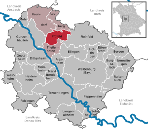
Weißenburg-Gunzenhausen
District in Bavaria, Germany
Distance: Approx. 6984 meters
Latitude and longitude: 49.08,10.83
is a Landkreis (district) in the west of Bavaria, Germany with a population of 95,000. Neighbouring districts are (from the north clockwise) Ansbach, Roth, Eichstätt and Donau-Ries. It is located in the south of Middle Franconia, 50 kilometres south of Nuremberg.

Gunzenhausen
Town in Bavaria, Germany
Distance: Approx. 244 meters
Latitude and longitude: 49.11472222,10.75416667
Gunzenhausen (German pronunciation: [ɡʊnt͡sn̩ˈhaʊ̯zn̩] ; Bavarian: Gunzenhausn) is a town in the Weißenburg-Gunzenhausen district, in Bavaria, Germany. It is situated on the river Altmühl, 19 kilometres (12 mi) northwest of Weißenburg in Bayern, and 45 kilometres (28 mi) southwest of Nuremberg. Gunzenhausen is a nationally recognized recreation area.

Gnotzheim
Municipality in Bavaria, Germany
Distance: Approx. 5998 meters
Latitude and longitude: 49.06666667,10.71666667
Gnotzheim is a municipality in the Weißenburg-Gunzenhausen district, in Bavaria, Germany.

Muhr am See
Municipality in Bavaria, Germany
Distance: Approx. 5106 meters
Latitude and longitude: 49.15555556,10.71666667
Muhr am See is a municipality in the Weißenburg-Gunzenhausen district, in Bavaria, Germany.

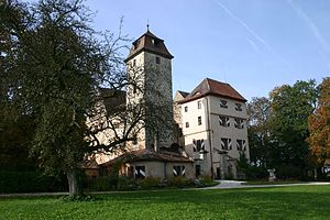
Pfofeld
Municipality in Bavaria, Germany
Distance: Approx. 5993 meters
Latitude and longitude: 49.11666667,10.83333333
Pfofeld is a municipality in the Weißenburg-Gunzenhausen district, in Franconia, Germany.

Franconian Lake District
Group of lakes northern Bavaria, Germany
Distance: Approx. 5038 meters
Latitude and longitude: 49.12827222,10.81748889
The Franconian Lake District lies south-west of Nuremberg in northern Bavaria, Germany. It was created as a result of one of Germany's largest water-management projects and was completed by the flooding of the Großer Brombachsee (" Great Brombach Lake") in 2000. The lakes of Altmühlsee, Brombachsee, Rothsee, Dennenloher See and Hahnenkammsee together form a lake district which is equal in size and infrastructure to the Upper Bavarian Lake District: the Altmühlsee, for example, is the same size as the Königssee, and the Große Brombachsee has the same area as the Tegernsee.
Cronheim
Stadtteil of Gunzenhausen in Bavaria, Germany
Distance: Approx. 6696 meters
Latitude and longitude: 49.09666667,10.66388889
Cronheim is a village in the municipality of Gunzenhausen in the Weißenburg-Gunzenhausen district which forms part of the Bavarian Government district (in German: Regierungbezirk) of Mittelfranken. The hamlet of Filchenhard forms part of Cronheim.
Schlangenbach (Altmühl)
River in Germany
Distance: Approx. 4243 meters
Latitude and longitude: 49.0869,10.7894
Schlangenbach is a small river in Bavaria, Germany. It is a right tributary of the Altmühl near Gunzenhausen.
Wachsteiner Bach
River in Germany
Distance: Approx. 6518 meters
Latitude and longitude: 49.0712,10.8094
Wachsteiner Bach is a small river of Bavaria, Germany. It flows into the Altmühl near Windsfeld.

Gunzenhausen station
Railway station in Gunzenhausen, Germany
Distance: Approx. 640 meters
Latitude and longitude: 49.12055556,10.75555556
Gunzenhausen station is apart from Cronheim station on the Nördlingen–Gunzenhausen railway, now operated as a heritage railway, the only station in the Bavarian town of Gunzenhausen and a hub of Middle Franconia. It is classified by Deutsche Bahn as a category 4 station. and has five platform tracks.
Brombachmoor
Distance: Approx. 7037 meters
Latitude and longitude: 49.130903,10.844815
The Brombachmoor is a nature reserve in the Franconian Lake District in the Middle Franconian county of Weißenburg-Gunzenhausen in the German state of Bavaria. The fen lies west of the Kleiner Brombachsee lake between the villages of Langlau and Absberg, near the Hühnermühle and Neuherberg in the parish of Thannhausen. Since 3 November 1983 it has been a designated Naturschutzgebiet with an area of 3.56 hectares, and thus the smallest nature reserve in the county.
Holzgraben (Altmühl)
River in Germany
Distance: Approx. 5767 meters
Latitude and longitude: 49.1571,10.7037
Holzgraben is a small river of Bavaria, Germany. It is a left tributary of the Altmühl at Muhr am See.
Weather in this IP's area
overcast clouds
11 Celsius
11 Celsius
8 Celsius
11 Celsius
1031 hPa
96 %
1031 hPa
981 hPa
10000 meters
2.06 m/s
3.11 m/s
65 degree
96 %
07:06:28
16:54:33
