23.28.124.68 - IP Lookup: Free IP Address Lookup, Postal Code Lookup, IP Location Lookup, IP ASN, Public IP
Country:
Region:
City:
Location:
Time Zone:
Postal Code:
ISP:
ASN:
language:
User-Agent:
Proxy IP:
Blacklist:
IP information under different IP Channel
ip-api
Country
Region
City
ASN
Time Zone
ISP
Blacklist
Proxy
Latitude
Longitude
Postal
Route
db-ip
Country
Region
City
ASN
Time Zone
ISP
Blacklist
Proxy
Latitude
Longitude
Postal
Route
IPinfo
Country
Region
City
ASN
Time Zone
ISP
Blacklist
Proxy
Latitude
Longitude
Postal
Route
IP2Location
23.28.124.68Country
Region
georgia
City
augusta
Time Zone
America/New_York
ISP
Language
User-Agent
Latitude
Longitude
Postal
ipdata
Country
Region
City
ASN
Time Zone
ISP
Blacklist
Proxy
Latitude
Longitude
Postal
Route
Popular places and events near this IP address
Augusta State University
Public university in Augusta, Georgia, US
Distance: Approx. 4230 meters
Latitude and longitude: 33.4768,-82.023
Augusta State University was a public university in Augusta, Georgia. It merged with Georgia Health Sciences University in 2012 to form Georgia Regents University, later known as Augusta University.
Aquinas High School (Georgia)
Private, coeducational, Roman Catholic school in Augusta, Georgia, United States
Distance: Approx. 3379 meters
Latitude and longitude: 33.46138889,-82.03861111
Aquinas High School is a private, Roman Catholic high school located in midtown Augusta, Georgia, United States. It is accredited by the Southern Association of Colleges and Schools and is a member of the Georgia High School Association and the National Catholic Educational Association.
WHHD
Radio station in Clearwater, South Carolina
Distance: Approx. 3881 meters
Latitude and longitude: 33.51222222,-82.08
WHHD (98.3 FM) is a top 40 (CHR) station serving the Augusta, Georgia metro area. It is owned by Beasley Broadcast Group, Inc., through licensee Beasley Media Group, LLC, and is licensed by the Federal Communications Commission (FCC) to Clearwater, South Carolina to broadcast with an effective radiated power (ERP) of 11.5 kW. Its studios are located just two blocks from the Augusta-Richmond County border in unincorporated Columbia County, Georgia and the transmitter is in Martinez, Georgia. It is the only Top 40 formatted station in the Augusta market.

Westminster Schools of Augusta
Private, Christian, college-preparatory school in Augusta, Georgia, United States
Distance: Approx. 2684 meters
Latitude and longitude: 33.489018,-82.042378
Westminster Schools of Augusta was founded in 1972 as a private, Christian, college-preparatory school located in the western section of Augusta, Georgia, United States. It serves students in grades pre-kindergarten through 12. The school is divided into three age groups, lower (pre-K to grade five), middle (grades six to eight), and upper (grades nine to 12).

Augusta Mall
Shopping mall in Georgia, United States
Distance: Approx. 1958 meters
Latitude and longitude: 33.46364,-82.07939
Augusta Mall is a two level super-regional shopping mall in Augusta, Georgia, United States. It is one of the largest malls in the state of Georgia, and it is the largest mall in the Augusta metropolitan area. The anchor stores are Dick's Sporting Goods, JCPenney, Dillard's, Macy's, and Barnes & Noble.
WRMK-LP
Radio station in Augusta, Georgia
Distance: Approx. 2818 meters
Latitude and longitude: 33.503,-82.06
WRMK-LP (100.3 FM) is a low power broadcasting radio station in Augusta, Georgia. The station is licensed by the Federal Communications Commission (FCC) to broadcast with an effective radiated power (ERP) of 100 watts. The station is co-located with Good News Church at 400 Warren Road, Augusta, Georgia.

Daniel Field
Airport
Distance: Approx. 3026 meters
Latitude and longitude: 33.46638889,-82.03944444
Daniel Field (IATA: DNL, ICAO: KDNL, FAA LID: DNL) is a public use airport located one nautical mile (2 km) west of the central business district of Augusta, a city in Richmond County, Georgia, United States. It is owned by the City of Augusta and operated by the General Aviation Commission. This airport is included in the National Plan of Integrated Airport Systems for 2021–2025, which categorized it as a general aviation facility.
Doctors Hospital (Augusta, Georgia)
Hospital in Georgia, United States
Distance: Approx. 2581 meters
Latitude and longitude: 33.48638889,-82.09472222
Doctors Hospital is a 350-bed full-service tertiary care center located in Augusta, Georgia.

Stephen Vincent Benét House
United States historic place
Distance: Approx. 4138 meters
Latitude and longitude: 33.4758,-82.02407
The Stephen Vincent Benét House, commonly referred to as Benét House, is a historic house on the Summerville campus of Augusta University in Augusta, Georgia. The house was built 1827–29 as the Commandant's House of the Augusta Arsenal, and is a much-altered example of Federal period architecture. The house was designated a National Historic Landmark in 1971 for its association with the Pulitzer Prize-winning writer Stephen Vincent Benét (1898–1943), who lived here in the 1910s.

Christenberry Fieldhouse
Distance: Approx. 1128 meters
Latitude and longitude: 33.47194444,-82.05944444
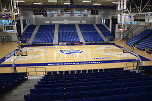
The George A. Christenberry Fieldhouse is a 3,026 seat facility on the campus of Augusta University in Augusta, Georgia, and is home to the athletics department as well as some classes. It is home to the Augusta Jaguars men's and women's basketball teams as well as the women's volleyball team. The first game at Christenberry Fieldhouse was held on February 2, 1991, against the University of South Carolina, a 76–62 loss.

Forest Hills Golf Club
Public facility in Augusta, United States
Distance: Approx. 1394 meters
Latitude and longitude: 33.47277778,-82.05527778
Forest Hills Golf Club in Augusta, Georgia, United States, is a public facility owned by Augusta University. It features an 18-hole course designed by Donald Ross in 1926, and re-designed by Arnold Palmer Company in 2004. Thirteen of the original holes and the clubhouse survive, though recent renovations have been done to the entryway.

Augusta Arsenal
Historic site in Augusta, Georgia
Distance: Approx. 4118 meters
Latitude and longitude: 33.47615,-82.02426
The Augusta Arsenal was a 19th-century fortification in Augusta, Georgia. Established in 1816 and initially completed on the Georgia bank of the Savannah River in 1819, it was moved to the former Belle Vue estate in the Summerville neighborhood of Augusta in 1827 due to health concerns after several fever epidemics.
Weather in this IP's area
clear sky
4 Celsius
3 Celsius
-1 Celsius
5 Celsius
1031 hPa
50 %
1031 hPa
1019 hPa
10000 meters
1.54 m/s
240 degree