23.249.109.71 - IP Lookup: Free IP Address Lookup, Postal Code Lookup, IP Location Lookup, IP ASN, Public IP
Country:
Region:
City:
Location:
Time Zone:
Postal Code:
IP information under different IP Channel
ip-api
Country
Region
City
ASN
Time Zone
ISP
Blacklist
Proxy
Latitude
Longitude
Postal
Route
Luminati
Country
Region
oh
City
newphiladelphia
ASN
Time Zone
America/New_York
ISP
MOMENTUM-ACCESS
Latitude
Longitude
Postal
IPinfo
Country
Region
City
ASN
Time Zone
ISP
Blacklist
Proxy
Latitude
Longitude
Postal
Route
IP2Location
23.249.109.71Country
Region
ohio
City
youngstown
Time Zone
America/New_York
ISP
Language
User-Agent
Latitude
Longitude
Postal
db-ip
Country
Region
City
ASN
Time Zone
ISP
Blacklist
Proxy
Latitude
Longitude
Postal
Route
ipdata
Country
Region
City
ASN
Time Zone
ISP
Blacklist
Proxy
Latitude
Longitude
Postal
Route
Popular places and events near this IP address

Youngstown, Ohio
City in Ohio
Distance: Approx. 47 meters
Latitude and longitude: 41.1,-80.65
Youngstown is a city in and the county seat of Mahoning County, Ohio, United States. At the 2020 census, it had a population of 60,068, making it the eleventh-most populous city in Ohio. It is a principal city of the Youngstown–Warren metropolitan area, which had 430,591 residents in 2020 and is the seventh-largest metro area in Ohio.

Youngstown Historical Center of Industry and Labor
Labor museum in Youngstown, Ohio
Distance: Approx. 344 meters
Latitude and longitude: 41.102533,-80.651417
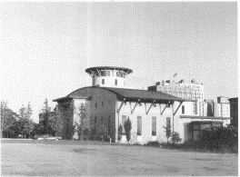
The Youngstown Historical Center of Industry and Labor, located in Youngstown, Ohio, preserves the history of the steel industry that dominated the Youngstown area's economic life for much of the 20th century. The museum is owned by the Ohio History Connection and operated by Youngstown State University. The facility, which was designed by noted architect Michael Graves, is reminiscent of a steel mill, complete with stylized smoke stacks.

Downtown Youngstown
Distance: Approx. 47 meters
Latitude and longitude: 41.1,-80.65
Downtown Youngstown is the urban downtown center of Youngstown, Ohio, United States. Located on the north bank of the Mahoning River, Downtown Youngstown is the site of most of the city's government buildings and banks. A number of entertainment venues are also located in downtown, including the Covelli Centre, Powers Auditorium, the DeYor Performing Arts Center, and Youngstown Foundation Amphitheatre.
Oakland Center for the Arts
Arts center in Youngstown, Ohio, U.S.A
Distance: Approx. 307 meters
Latitude and longitude: 41.100766,-80.652934
The Oakland Center for the Arts (or the Oakland, as it is usually called) is an interdisciplinary arts center based in Youngstown, Ohio founded in 1986.

Liberty/Paramount Theatre
United States historic place
Distance: Approx. 233 meters
Latitude and longitude: 41.10111111,-80.65166667
The Liberty/Paramount Theatre was an early movie palace located on West Federal Street and Hazel Avenue in Youngstown, Ohio. Designed by Detroit architect C. Howard Crane, the theatre opened as the Liberty Theatre on February 11, 1918. The auditorium originally seated 1,700 patrons.

Metropolitan Tower (Youngstown)
United States historic place
Distance: Approx. 69 meters
Latitude and longitude: 41.1,-80.65027778
Metropolitan Tower is a skyscraper in Youngstown, Ohio. Designed by Morris Scheibel, the building rises to a height of 224 feet (68 m). It has been the tallest building in the city since its completion in 1929, surpassing the Wick Building.

Masonic Temple (Youngstown, Ohio)
United States historic place
Distance: Approx. 344 meters
Latitude and longitude: 41.1025,-80.6475
The Masonic Temple in Youngstown, Ohio is a building from 1909. It was listed on the National Register of Historic Places in 1997. In January, 2016 it was announced that Wick Lodge No.

Wick Building
United States historic place
Distance: Approx. 122 meters
Latitude and longitude: 41.10055556,-80.65055556
The Wick Building, also known as The Wick Tower, is a high rise structure and second tallest building in Youngstown, Ohio. Constructed by D. H. Burnham & Company in 1910, the structure contains 13 floors and rises to a height of 184 feet. It is a classic example of Chicago School architecture, and contains a row of arches at the crown.

Helen Chapel
Historic chapel in Youngstown, Ohio
Distance: Approx. 278 meters
Latitude and longitude: 41.10138889,-80.64694444
The Helen Chapel is a historic chapel at the northwest corner of East Wood and Champion Streets in Youngstown, Ohio. It was completed in 1890 and added to the National Register of Historic Places in 1986.

Youngstown station (Erie Railroad)
Railroad station in Youngstown, Ohio
Distance: Approx. 231 meters
Latitude and longitude: 41.10182,-80.65014
Youngstown was a station along the Erie Railroad and later the Erie-Lackawanna Railway, from 1922 to 1977 in Youngstown, Ohio. All railroad tracks behind the terminal have been removed, and the building is currently known as Erie Terminal Place, alternative student housing for students attending Youngstown State University.
A Handshake for the Century
Statue in Youngstown, Ohio, U.S.
Distance: Approx. 356 meters
Latitude and longitude: 41.09661111,-80.64988889
A Handshake for the Century is a bronze statue located in Youngstown, Ohio. The statue commemorates a handshake between African American baseball player Jackie Robinson of the Montreal Royals and his white teammate George Shuba, a native of Youngstown. Created by sculptor Marc Mellon, it was veiled in 2021, seventy-five years after it occurred.

Realty Building explosion
2024 fatal building explosion in a downtown area
Distance: Approx. 44 meters
Latitude and longitude: 41.09964,-80.64902
On May 28, 2024, a large and powerful explosion destroyed most of the first floor of the Realty Building in the downtown district of Youngstown, Ohio, US, and severely damaged the floors above it, killing one bank employee and injuring seven. The explosion was suspected to have been caused by a natural gas leak, although the official cause of the explosion is still under investigation.
Weather in this IP's area
overcast clouds
-1 Celsius
-1 Celsius
-2 Celsius
-1 Celsius
1016 hPa
76 %
1016 hPa
976 hPa
10000 meters
0.89 m/s
1.34 m/s
193 degree
96 %