23.247.248.76 - IP Lookup: Free IP Address Lookup, Postal Code Lookup, IP Location Lookup, IP ASN, Public IP
Country:
Region:
City:
Location:
Time Zone:
Postal Code:
ISP:
ASN:
language:
User-Agent:
Proxy IP:
Blacklist:
IP information under different IP Channel
ip-api
Country
Region
City
ASN
Time Zone
ISP
Blacklist
Proxy
Latitude
Longitude
Postal
Route
db-ip
Country
Region
City
ASN
Time Zone
ISP
Blacklist
Proxy
Latitude
Longitude
Postal
Route
IPinfo
Country
Region
City
ASN
Time Zone
ISP
Blacklist
Proxy
Latitude
Longitude
Postal
Route
IP2Location
23.247.248.76Country
Region
michigan
City
ramsay
Time Zone
America/Menominee
ISP
Language
User-Agent
Latitude
Longitude
Postal
ipdata
Country
Region
City
ASN
Time Zone
ISP
Blacklist
Proxy
Latitude
Longitude
Postal
Route
Popular places and events near this IP address

Bessemer, Michigan
City in Michigan, United States
Distance: Approx. 4500 meters
Latitude and longitude: 46.47805556,-90.05138889
Bessemer is a city in the U.S. state of Michigan. As of the 2020 census, the city population was 1,805. It is the county seat of Gogebic County.

Bessemer Township, Michigan
Civil township in Michigan, United States
Distance: Approx. 6316 meters
Latitude and longitude: 46.42055556,-89.9975
Bessemer Township is a civil township of Gogebic County in the U.S. state of Michigan. As of 2020, its population was 1,135.

Wakefield, Michigan
City in Michigan, United States
Distance: Approx. 4106 meters
Latitude and longitude: 46.47611111,-89.93916667
Wakefield is a city in Gogebic County in the U.S. state of Michigan. The population was 1,702 at the 2020 census. Wakefield is located in the western Upper Peninsula about 10 miles (16 km) east of the Wisconsin border.

WUPM
Radio station in Ironwood, Michigan
Distance: Approx. 1589 meters
Latitude and longitude: 46.472,-90.012
WUPM (106.9 FM) is a radio station licensed to Ironwood, Michigan, United States, broadcasting a hot adult contemporary music format. The station began broadcasting in 1978 as a Top 40 (CHR) format, and has featured a contemporary music format throughout its history.
Snow River Mountain Resort
Ski area in Michigan, United States
Distance: Approx. 3041 meters
Latitude and longitude: 46.5,-89.97083333
Snow River Mountain Resort is located in the Upper Peninsula of Michigan in Wakefield Township, Gogebic County. Indianhead Mountain is in an area called "Big Snow Country", so named because of the annual 200-inch (5.1 m) average snowfall, courtesy of the lake effect from Lake Superior. It consists of the Jackson Creek Summit, formerly Indianhead Mountain, and Black River Basin, formerly known as Blackjack.

Big Powderhorn Mountain
Ski area in Michigan, United States
Distance: Approx. 8475 meters
Latitude and longitude: 46.50416667,-90.09611111
Big Powderhorn Mountain is a 250-acre (1.0 km2) ski resort located in Gogebic County in the Upper Peninsula of Michigan, within Bessemer Township and Ironwood Township (between the cities of Bessemer and Ironwood). The mountain is part of the Gogebic Range with a summit of 1,640 ft (500m) and a base elevation of 1,240 ft (378m), for a 400 ft. vertical drop.
Wolverine Hill
Closed ski jumping hill in Michigan, United States
Distance: Approx. 9419 meters
Latitude and longitude: 46.49111111,-90.11391667
Wolverine Hill was a ski jumping hill located in Ironwood, Michigan, United States.
Gogebic County Courthouse
United States historic place
Distance: Approx. 4660 meters
Latitude and longitude: 46.48222222,-90.05305556
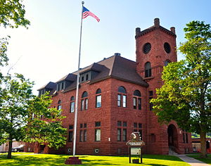
The Gogebic County Courthouse is a government building located on North Moore Street in Bessemer, Michigan. It was listed on the National Register of Historic Places in 1981 and designated a Michigan State Historic Site in 1971.

Main Street–Black River Bridge
United States historic place
Distance: Approx. 777 meters
Latitude and longitude: 46.47361111,-90.00138889
The Main Street–Black River Bridge is a bridge located on Main Street over the Black River in Ramsay, Bessemer Township, Michigan, USA. It was listed on the National Register of Historic Places in 1999.

Planter Road–Jackson Creek Bridge
United States historic place
Distance: Approx. 4382 meters
Latitude and longitude: 46.51333333,-89.97
The Planter Road – Jackson Creek Bridge is a bridge located on Planter Road over Jackson Creek in Wakefield Township, Michigan. It was listed on the National Register of Historic Places in 1999.
Siemens, Michigan
Unincorporated community in Michigan, United States
Distance: Approx. 8506 meters
Latitude and longitude: 46.475,-90.10361111
Siemens is an unincorporated community in Gogebic County, in the U.S. state of Michigan. It is located halfway between Ironwood and Bessemer along U.S. Route 2.
Anvil, Michigan
Unincorporated community in Michigan, United States
Distance: Approx. 2131 meters
Latitude and longitude: 46.47027778,-90.01861111
Anvil is an unincorporated community in Gogebic County, Michigan, United States.
Weather in this IP's area
overcast clouds
-9 Celsius
-16 Celsius
-10 Celsius
-9 Celsius
1013 hPa
73 %
1013 hPa
955 hPa
8047 meters
6.69 m/s
10.8 m/s
210 degree
100 %
