23.247.180.193 - IP Lookup: Free IP Address Lookup, Postal Code Lookup, IP Location Lookup, IP ASN, Public IP
Country:
Region:
City:
Location:
Time Zone:
Postal Code:
ISP:
ASN:
language:
User-Agent:
Proxy IP:
Blacklist:
IP information under different IP Channel
ip-api
Country
Region
City
ASN
Time Zone
ISP
Blacklist
Proxy
Latitude
Longitude
Postal
Route
db-ip
Country
Region
City
ASN
Time Zone
ISP
Blacklist
Proxy
Latitude
Longitude
Postal
Route
IPinfo
Country
Region
City
ASN
Time Zone
ISP
Blacklist
Proxy
Latitude
Longitude
Postal
Route
IP2Location
23.247.180.193Country
Region
indiana
City
lafayette
Time Zone
America/Indiana/Indianapolis
ISP
Language
User-Agent
Latitude
Longitude
Postal
ipdata
Country
Region
City
ASN
Time Zone
ISP
Blacklist
Proxy
Latitude
Longitude
Postal
Route
Popular places and events near this IP address

Roman Catholic Diocese of Lafayette in Indiana
Latin Catholic ecclesiastical jurisdiction in Indiana, USA
Distance: Approx. 247 meters
Latitude and longitude: 40.41722222,-86.87861111
The Diocese of Lafayette in Indiana (Latin: Dioecesis Lafayettensis in Indiana) is a Latin Church ecclesiastical territory, or diocese, of the Catholic Church in central Indiana in the United States. The current bishop is Timothy L. Doherty. The Diocese of Lafayette in Indiana is a suffragan diocese in the ecclesiastical province of the metropolitan Archdiocese of Indianapolis.
Lafayette Home Hospital
Distance: Approx. 603 meters
Latitude and longitude: 40.41833333,-86.86877778
Lafayette Home Hospital was a 270-bed medical center in Lafayette, Indiana, United States, owned by the not-for-profit Franciscan Health, a division of Sisters of St. Francis Health Services, Inc. The facility ceased all medical services on February 25, 2010.
Loeb Stadium (1940)
Demolished stadium in Indiana, USA
Distance: Approx. 611 meters
Latitude and longitude: 40.412597,-86.871568
Loeb Stadium was a stadium in Columbian Park in Lafayette, Indiana, United States. It was primarily used for baseball and had most recently been the home of the Lafayette Aviators of the Prospect League. Previously, it was the home of Ohio Valley Redcoats of the independent Frontier League, and later the Lafayette Leopards of the now defunct Great Central League.

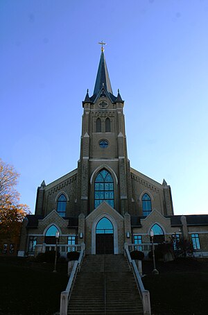
Cathedral of Saint Mary of the Immaculate Conception (Lafayette, Indiana)
Church in Indiana, United States
Distance: Approx. 702 meters
Latitude and longitude: 40.41805556,-86.88388889
The Cathedral of Saint Mary of the Immaculate Conception is the cathedral of the Roman Catholic Diocese of Lafayette in Indiana. It is located at 1207 Columbia Street in Lafayette, Indiana. It is also a contributing property in the St.
Columbian Park Zoo
Zoo in Indiana, United States
Distance: Approx. 524 meters
Latitude and longitude: 40.4141335,-86.8709012
The Columbian Park Zoo is a seasonal zoo located in Lafayette, Indiana, at Columbian Park. The zoo is home to more than 190 animals from over 90 species. The zoo is in Columbian Park, which also includes playgrounds, picnic areas, a walking trail, and a baseball stadium.

St. Mary Historic District (Lafayette, Indiana)
Historic district in Indiana, United States
Distance: Approx. 435 meters
Latitude and longitude: 40.41694444,-86.88083333
St. Mary Historic District is a national historic district located at Lafayette, Tippecanoe County, Indiana. In 1864, St.

William Potter House
Historic house in Indiana, United States
Distance: Approx. 842 meters
Latitude and longitude: 40.41805556,-86.88555556
William Potter House, also known as the Potter House, is a historic home located at Lafayette, Tippecanoe County, Indiana. It was built in 1855, and is a two-story, Greek Revival style brick dwelling, with a front gable roof. A rear addition was added about 1880.

James H. Ward House
Historic house in Indiana, United States
Distance: Approx. 707 meters
Latitude and longitude: 40.41833333,-86.88388889
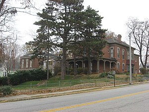
James H. Ward House is a historic home located at Lafayette, Tippecanoe County, Indiana. It was built about 1875, and is a two-story Italianate / Second Empire style brick dwelling, with a 3+1⁄2-story mansard roofed tower. It features deep overhanging eaves with corner brackets, asymmetrical massing, and an ornate semi-hexagonal, two-story projecting bay.

Enterprise Hotel
United States historic place
Distance: Approx. 813 meters
Latitude and longitude: 40.41888889,-86.885
Enterprise Hotel, also known as Gasthaus Alt Heidelberg, is a historic hotel building located at Lafayette, Tippecanoe County, Indiana. It was built in 1895, and is a three-story, five-bay, rectangular, Italianate style brick building, with rear additions. It measures 42 feet wide and 32 feet deep.

Scott Street Pavilion
United States historic place
Distance: Approx. 414 meters
Latitude and longitude: 40.415,-86.87166667
Scott Street Pavilion is a historic park pavilion located in Columbian Park at Lafayette, Tippecanoe County, Indiana. It was built in 1899, and is a 1+1⁄2-story, rectangular, wood-frame building. It is sheathed in clapboard siding and has a hipped roof that extends to form a verandah on all sides.: 2–3 It was listed on the National Register of Historic Places in 1984.

Perrin Historic District
Historic district in Indiana, United States
Distance: Approx. 514 meters
Latitude and longitude: 40.42055556,-86.87972222
Perrin Historic District is a national historic district located at Lafayette, Tippecanoe County, Indiana. The district encompasses 173 contributing buildings and 2 contributing structures in a predominantly residential section of Lafayette. It developed between about 1869 and 1923 and includes representative examples of Italianate, Queen Anne, Colonial Revival, Stick Style / Eastlake movement, and Bungalow / American Craftsman style architecture.

Loeb Stadium
Stadium in Lafayette, Indiana
Distance: Approx. 695 meters
Latitude and longitude: 40.41166667,-86.87166667
Loeb Stadium is a multi-use stadium in Columbian Park in Lafayette, Indiana, United States. It is the home field for the Lafayette Aviators, a collegiate summer baseball team in the Prospect League, and for the Jefferson High School Bronchos baseball team. It was the home for Black Cat FC in the United Premier Soccer League during their 2021 season.
Weather in this IP's area
clear sky
-18 Celsius
-25 Celsius
-18 Celsius
-18 Celsius
1035 hPa
71 %
1035 hPa
1006 hPa
10000 meters
4.12 m/s
270 degree