23.186.216.26 - IP Lookup: Free IP Address Lookup, Postal Code Lookup, IP Location Lookup, IP ASN, Public IP
Country:
Region:
City:
Location:
Time Zone:
Postal Code:
ISP:
ASN:
language:
User-Agent:
Proxy IP:
Blacklist:
IP information under different IP Channel
ip-api
Country
Region
City
ASN
Time Zone
ISP
Blacklist
Proxy
Latitude
Longitude
Postal
Route
db-ip
Country
Region
City
ASN
Time Zone
ISP
Blacklist
Proxy
Latitude
Longitude
Postal
Route
IPinfo
Country
Region
City
ASN
Time Zone
ISP
Blacklist
Proxy
Latitude
Longitude
Postal
Route
IP2Location
23.186.216.26Country
Region
colorado
City
denver
Time Zone
America/Denver
ISP
Language
User-Agent
Latitude
Longitude
Postal
ipdata
Country
Region
City
ASN
Time Zone
ISP
Blacklist
Proxy
Latitude
Longitude
Postal
Route
Popular places and events near this IP address

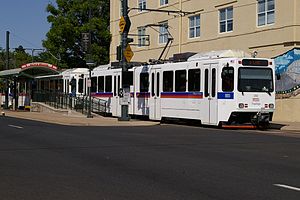
30th & Downing station
Light rail station in Denver, Colorado
Distance: Approx. 310 meters
Latitude and longitude: 39.758805,-104.973536
30th & Downing station (sometimes styled as 30th•Downing) is a RTD light rail station in the Five Points neighborhood of Denver, Colorado, United States. Originally operating as part of the D Line, the station was opened on October 8, 1994, and is operated by the Regional Transportation District. It is the current northern terminus for Five Points trains.

Manual High School (Colorado)
Public high school in Denver, Colorado, United States
Distance: Approx. 404 meters
Latitude and longitude: 39.75666667,-104.9675
Manual High School is located in the Whittier neighborhood on the east side of Denver, Colorado, United States.
Cole, Denver
Neighborhood of Denver, Colorado, US
Distance: Approx. 885 meters
Latitude and longitude: 39.767,-104.966
Cole is a neighborhood of Denver, Colorado. It is in the area commonly known as North Denver. According to the Piton Foundation in 2007 the population of the neighborhood was 6,041, and there were 1,794 housing units.

Annunciation Roman Catholic Church (Denver)
Historic Catholic parish in Colorado, United States
Distance: Approx. 838 meters
Latitude and longitude: 39.76722222,-104.96972222
The Annunciation Church in Denver, Colorado is an historic Catholic parish church at 3601 Humboldt Street. It is part of the Archdiocese of Denver. The structure was built during 1904 to 1907 and was added to the National Register in 1990, one of several registered in northeast Denver.
Curtis–Champa Streets Historic District
Historic district in Colorado, United States
Distance: Approx. 958 meters
Latitude and longitude: 39.75683,-104.98065
Curtis–Champa Streets Historic District is located in Denver, Colorado. It was added to the National Register of Historic Places in 1975 and is bounded by Arapahoe, 30th, California, and 24th Sts. covering 870 acres and 356 buildings.
25th & Welton station
Light rail station in Denver, Colorado
Distance: Approx. 1085 meters
Latitude and longitude: 39.753378,-104.97975
25th & Welton station (sometimes styled as 25th•Welton) is a RTD light rail station in Denver, Colorado, United States. Originally operating as part of the D Line, the station was opened on October 8, 1994, and is operated by the Regional Transportation District. Located in the Five Points neighborhood, it is the stop closest to the Blair-Caldwell African American Research Library.
27th & Welton station
Light rail station in Denver, Colorado
Distance: Approx. 797 meters
Latitude and longitude: 39.755234,-104.977372
27th & Welton station (sometimes styled as 27th•Welton) is a RTD light rail station in the Five Points neighborhood of Denver, Colorado, United States. Originally operating as part of the D Line, the station was opened on December 19, 1995, and is operated by the Regional Transportation District. The stop was opened over a year after the rest of light rail line after support from the neighborhood.

29th & Welton station
Former light rail station in Denver, Colorado
Distance: Approx. 536 meters
Latitude and longitude: 39.756919,-104.975211
29th & Welton station was an RTD light rail station in the Five Points neighborhood of Denver, Colorado, United States. Formerly operating as part of the D Line, the station was opened on October 8, 1994, and was operated by the Regional Transportation District. The station closed on January 6, 2013, as part of RTD's January Service Changes to help with keeping trains running on time and improving bus connections at the 30th & Downing station.

Rossonian Hotel
United States historic place
Distance: Approx. 901 meters
Latitude and longitude: 39.75416667,-104.97777778
The Rossonian Hotel is a historic building and former business located at 2650 Welton Street in the Five Points section of Denver, Colorado, United States. It is listed on the National Register of Historic Places since in 1995, for ethnic heritage and social history. It has also been known as the Baxter Building and as the Baxter Hotel.
John Elsner House
United States historic place
Distance: Approx. 920 meters
Latitude and longitude: 39.75916667,-104.98083333
The John Elsner House is an Italianate-style house located at 2810 Arapahoe Street in Denver, Colorado. It was added to the National Register of Historic Places on December 17, 1979. The house was commissioned in 1872 by Denver physician John Elsner.
Beckon
Restaurant in Denver, Colorado, U.S.
Distance: Approx. 1059 meters
Latitude and longitude: 39.76113889,-104.98233333
Beckon is a Michelin-starred restaurant in Denver, Colorado. In 2024, Beckon was a semifinalist in the Outstanding Restaurant category of the James Beard Foundation Awards.

Cervantes' Masterpiece Ballroom
Concert venue in Denver, Colorado
Distance: Approx. 934 meters
Latitude and longitude: 39.75444444,-104.97861111
Cervantes' Masterpiece Ballroom is an independent live music venue in Denver, Colorado, with two rooms (Cervantes’ Ballroom and Cervantes’ Other Side) that offer live music and events simultaneously. It is located in Denvers' historic Five Points neighborhood. It was originally a live jazz venue by Benny Hooper called the Ex-Servicemen's Club.
Weather in this IP's area
clear sky
4 Celsius
3 Celsius
2 Celsius
7 Celsius
1020 hPa
46 %
1020 hPa
838 hPa
10000 meters
1.54 m/s
210 degree


