23.176.0.107 - IP Lookup: Free IP Address Lookup, Postal Code Lookup, IP Location Lookup, IP ASN, Public IP
Country:
Region:
City:
Location:
Time Zone:
Postal Code:
ISP:
ASN:
language:
User-Agent:
Proxy IP:
Blacklist:
IP information under different IP Channel
ip-api
Country
Region
City
ASN
Time Zone
ISP
Blacklist
Proxy
Latitude
Longitude
Postal
Route
db-ip
Country
Region
City
ASN
Time Zone
ISP
Blacklist
Proxy
Latitude
Longitude
Postal
Route
IPinfo
Country
Region
City
ASN
Time Zone
ISP
Blacklist
Proxy
Latitude
Longitude
Postal
Route
IP2Location
23.176.0.107Country
Region
ontario
City
brampton
Time Zone
America/Toronto
ISP
Language
User-Agent
Latitude
Longitude
Postal
ipdata
Country
Region
City
ASN
Time Zone
ISP
Blacklist
Proxy
Latitude
Longitude
Postal
Route
Popular places and events near this IP address

Brampton North (provincial electoral district)
Provincial electoral district in Ontario, Canada
Distance: Approx. 2600 meters
Latitude and longitude: 43.74,-79.77
Brampton North is a provincial electoral district in Ontario. It was originally created prior to the 1987 election from part of Brampton. It existed for the 1987, 1990, and 1995 elections.

Toronto Ontario Temple
Latter-day Saints temple in Canada
Distance: Approx. 1684 meters
Latitude and longitude: 43.744338,-79.746059
The Toronto Ontario Temple is the 44th operating temple of the Church of Jesus Christ of Latter-day Saints (LDS Church). The intent to build the temple was announced to local leaders on the morning of April 7, 1984, and then referenced by Gordon B. Hinckley, second counselor in the First Presidency, during the general conference session which followed. It was the second temple built in Canada (after the Cardston Alberta Temple), becoming the first country in the world, outside the United States, to have two temples in its borders.
Mayfield Secondary School
High school in Caledon, Ontario, Canada
Distance: Approx. 2999 meters
Latitude and longitude: 43.7741,-79.7821
Mayfield Secondary School is located in Caledon, Ontario, Canada. It is one of the Regional Arts Schools in the Peel District School Board.

Professor's Lake
Artificial lake in Brampton, Ontario
Distance: Approx. 1842 meters
Latitude and longitude: 43.7475,-79.73472222
Professor's Lake is a 65-acre (26 ha) spring-fed artificial lake located in Brampton, Ontario, Canada. In 1918, the area where the lake currently exists was a sand and gravel mining site supplying aggregates for construction projects in the northwest area of the Greater Toronto Area. During its lifetime, the site produced approximately 20 million tonnes (40 million tons) of aggregate.

Brampton Civic Hospital
Hospital in Ontario, Canada
Distance: Approx. 1453 meters
Latitude and longitude: 43.7473,-79.7432
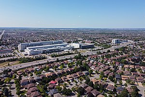
Brampton Civic Hospital is an acute care hospital in Brampton, Ontario and part of the William Osler Health System. It is a community teaching hospital for the Michael G. DeGroote School of Medicine of McMaster University.
Harold M. Brathwaite Secondary School
High school in Brampton, Ontario, Canada
Distance: Approx. 2651 meters
Latitude and longitude: 43.73972222,-79.77055556
Harold M. Brathwaite Secondary School is a public high school located in Brampton, Ontario, Canada. The school is named after Harold M. Brathwaite (d.2020), a former director of education of the Peel District School Board. Harold M. Brathwaite offers the International Baccalaureate program.

Save Max Sports Centre
Distance: Approx. 2231 meters
Latitude and longitude: 43.7436,-79.76895
Brampton Soccer Centre, inaugurated on June 25, 2007, is now known as Save Max Sports Centre. Raman Dua, Founder and Group CEO of Save Max Real Estate Inc., finalized a 15-year agreement with the City of Brampton for exterior naming rights in 2020.
Sandalwood Heights Secondary School
Public high school in Brampton, Ontario, Canada
Distance: Approx. 962 meters
Latitude and longitude: 43.7659,-79.744
Sandalwood Heights Secondary School is a Canadian high school located in the city of Brampton, Ontario and is a part of the Peel District School Board. It opened in 2007. The Specialist High Skills Major program (SHSM) features student pathways in the business sector.

St. Marguerite d'Youville Secondary School
Separate secondary school in Brampton, Ontario, Canada
Distance: Approx. 2174 meters
Latitude and longitude: 43.7523,-79.7766
St. Marguerite d'Youville Secondary School (often referred to as d'Youville or abbreviated to d'Y) is a Catholic high school in Brampton, Ontario, Canada, in the Dufferin-Peel Catholic District School Board (DPCDSB).

Louise Arbour Secondary School
Public high school in Brampton, Ontario, Canada
Distance: Approx. 1275 meters
Latitude and longitude: 43.76,-79.767
Louise Arbour Secondary School is a high school located in Brampton, Ontario, operating under the Peel District School Board. It was established in 2010 to accommodate those who live in north Brampton between Sandalwood Heights Secondary School and Mayfield Secondary School. A social justice focus infuses all elements of the curriculum in order to support students to become socially responsible citizens of the world.

Brampton North (federal electoral district)
Federal electoral district in Ontario, Canada
Distance: Approx. 2600 meters
Latitude and longitude: 43.74,-79.77
Brampton North (French: Brampton-Nord) is a federal electoral district in Ontario, Canada. It encompass portions of Ontario formerly included in the electoral districts of Brampton—Springdale, Bramalea—Gore—Malton and Brampton West. Brampton North was created by the 2012 federal electoral boundaries redistribution and was legally defined in the 2013 representation order.

Brampton Library, Springdale branch
Library building in Ontario, Canada
Distance: Approx. 820 meters
Latitude and longitude: 43.758,-79.7613
The Brampton Library, Springdale branch and Komagata Maru Park, designed by RDH Architects, is near the intersection of Bramalea Road and Sandalwood Parkway in Springdale, Brampton, Ontario, Canada. It is an example of " progressive organic architecture and urbanism that focuses on an experience set within the typical fabric of a North American suburb." Inaugurated in 2019, the opening of Brampton Library's Springdale Branch introduced a single storey structure. It rests on a triangular footprint of the library that optimizes the utilization of green areas.
Weather in this IP's area
overcast clouds
-2 Celsius
-9 Celsius
-3 Celsius
-2 Celsius
1016 hPa
79 %
1016 hPa
986 hPa
10000 meters
8.75 m/s
220 degree
100 %