23.175.240.79 - IP Lookup: Free IP Address Lookup, Postal Code Lookup, IP Location Lookup, IP ASN, Public IP
Country:
 Canada
Region:
City:
Location:
Time Zone:
Postal Code:
ISP:
ASN:
language:
User-Agent:
Proxy IP:
Blacklist:
IP information under different IP Channel
ip-api
Country
Region
City
ASN
Time Zone
ISP
Blacklist
Proxy
Latitude
Longitude
Postal
Route
db-ip
Country
Region
City
ASN
Time Zone
ISP
Blacklist
Proxy
Latitude
Longitude
Postal
Route
IPinfo
Country
Region
City
ASN
Time Zone
ISP
Blacklist
Proxy
Latitude
Longitude
Postal
Route
IP2Location
23.175.240.79Country
caRegion
ontario
City
toronto
Time Zone
America/Toronto
ISP
Language
User-Agent
Latitude
Longitude
Postal
ipdata
Country
Region
City
ASN
Time Zone
ISP
Blacklist
Proxy
Latitude
Longitude
Postal
Route
Popular places and events near this IP address
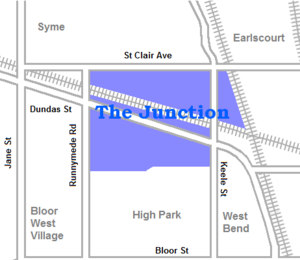
The Junction
Neighbourhood in Toronto, Ontario, Canada
Distance: Approx. 287 meters
Latitude and longitude: 43.66555556,-79.46444444
The Junction is a neighbourhood in Toronto, Ontario, Canada, that is near the West Toronto Diamond, a junction of four railway lines in the area. The neighbourhood was previously an independent city called West Toronto, that was also its own federal electoral district until amalgamating with the city of Toronto in 1909. The main intersection of the area is Dundas Street West and Keele Street.

Portuguese Seventh-day Adventist Church (Toronto)
Distance: Approx. 351 meters
Latitude and longitude: 43.6624908,-79.4696884
The Portuguese Seventh-day Adventist Church is a Seventh-day Adventist church serving the Portuguese community of Toronto, Ontario, Canada. The congregation is currently meeting every Saturday at the High Park Korean United Church building located at 260 High Park Ave.

West Toronto Diamond
Railway station in Toronto, Ontario, Canada
Distance: Approx. 675 meters
Latitude and longitude: 43.66722222,-79.46
The West Toronto Diamond is a railway junction in Toronto, Ontario, Canada. It connects the Metrolinx Weston Subdivision, which carries the GO Transit Kitchener line, UP Express and Via Rail Corridor passenger services, to the CPKC North Toronto Subdivision, which is the Canadian Pacific Kansas City's main freight line across Toronto. It is located near the intersection of Keele Street and Dundas Street in Toronto.

CPKC West Toronto Yard
Rail yard in Canada
Distance: Approx. 694 meters
Latitude and longitude: 43.6675,-79.47611111
CPKC West Toronto Yard is a small marshalling yard for the Canadian Pacific Kansas City on the Galt Subdivision in Toronto, Ontario, Canada. The yard was built in 1882 to relieve stress at the Parkdale Yard and is located near Keele Street and Dundas Street West in The Junction. It was once the main yards for Toronto, but was replaced in that role in April 1964 by the CPR Toronto Yard in Agincourt.
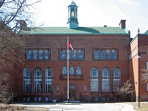
Humberside Collegiate Institute
High school in High Park North, Toronto, Ontario, Canada
Distance: Approx. 645 meters
Latitude and longitude: 43.659943,-79.470677
Humberside Collegiate Institute (also known as Humberside CI, HCI, or Humberside), formerly known as Toronto Junction High School and Toronto Junction Collegiate Institute is a public high school located in Toronto, Ontario, Canada. It serves the Bloor West Village, Baby Point, High Park North and Junction neighbourhoods. Prior to 1998, it was within the Toronto Board of Education (TBE).

Runnymede Park
Park in The Junction neighborhood of Toronto
Distance: Approx. 958 meters
Latitude and longitude: 43.668238,-79.479228
Runnymede Park is a medium-sized public park located in The Junction neighbourhood of Toronto, Canada, one block east of Runnymede Road. Its southern boundary is the West Toronto Yard used by the Canadian Pacific Railway, its northern boundary is Ryding Avenue, while a laneway and parking lot make up the western and eastern boundaries respectively. It is relatively flat, and features many soaring mature oak trees.
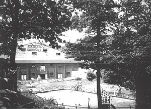
Ravina Gardens
Ice hockey arena
Distance: Approx. 769 meters
Latitude and longitude: 43.659675,-79.47333889
Ravina Gardens was an ice hockey arena located in Toronto, Ontario, Canada. It supported amateur hockey from before World War I until 1961, and professional hockey briefly in the 1920s. The location of the demolished arena is parkland, and is known as Ravina Gardens.

Gunns Loop
Distance: Approx. 778 meters
Latitude and longitude: 43.67194444,-79.47138889
Gunns Loop is a station and turning loop at the western terminus of the 512 St. Clair streetcar line of the Toronto Transit Commission (TTC). It is located at the northwest corner of St.

Congregation Knesseth Israel (Toronto)
Orthodox Jewish congregation in Toronto, Ontario, Canada
Distance: Approx. 615 meters
Latitude and longitude: 43.666354,-79.475527
Congregation Knesseth Israel, also known as the Junction Shul, is an Orthodox Jewish congregation in Toronto, Ontario, Canada. Its synagogue building is the oldest surviving in Toronto that is still in use, and was designated an Ontario Heritage site in 1984 under the Ontario Heritage Act. Located at 56 Maria Street, in Toronto's Junction neighbourhood, the congregation was established in 1909 by Jewish immigrants, largely from Russia and Poland.

Brother Edmund Rice Catholic Secondary School
High school in Toronto, Ontario, Canada
Distance: Approx. 1020 meters
Latitude and longitude: 43.66774,-79.45575
Brother Edmund Rice Catholic Secondary School (equally known as Brother Edmund Rice CSS, BERCSS, Brother Edmund Rice, or Rice) is a former publicly funded high school in Toronto, Ontario, Canada managed by the Toronto Catholic District School Board. It was named after Edmund Ignatius Rice, a Roman Catholic missionary and educationalist and the founder of two religious institutes of religious brothers: the Congregation of Christian Brothers and the Presentation Brothers.

Stock Yards Village
Shopping centre in The Junction, Toronto, Ontario, Canada
Distance: Approx. 858 meters
Latitude and longitude: 43.6728,-79.471
Stock Yards Village (commonly misspelled as Stockyards Village) is a shopping centre in Toronto, Ontario, Canada. It is located at Weston Road and St. Clair Avenue West in The Junction neighbourhood.
St. Clair–Old Weston GO Station
Planned commuter train station in Toronto
Distance: Approx. 963 meters
Latitude and longitude: 43.674,-79.4667
St. Clair–Old Weston GO Station (also referred to as St. Clair) is a planned commuter train station in Toronto, Ontario, Canada.
Weather in this IP's area
few clouds
-3 Celsius
-9 Celsius
-4 Celsius
-2 Celsius
1021 hPa
64 %
1021 hPa
1005 hPa
10000 meters
4.47 m/s
8.05 m/s
342 degree
22 %