23.174.232.99 - IP Lookup: Free IP Address Lookup, Postal Code Lookup, IP Location Lookup, IP ASN, Public IP
Country:
 USA
USARegion:
City:
Location:
Time Zone:
Postal Code:
ISP:
ASN:
language:
User-Agent:
Proxy IP:
Blacklist:
IP information under different IP Channel
ip-api
Country
Region
City
ASN
Time Zone
ISP
Blacklist
Proxy
Latitude
Longitude
Postal
Route
db-ip
Country
Region
City
ASN
Time Zone
ISP
Blacklist
Proxy
Latitude
Longitude
Postal
Route
IPinfo
Country
Region
City
ASN
Time Zone
ISP
Blacklist
Proxy
Latitude
Longitude
Postal
Route
IP2Location
23.174.232.99Country
usRegion
oregon
City
mosier
Time Zone
America/Los_Angeles
ISP
Language
User-Agent
Latitude
Longitude
Postal
ipdata
Country
Region
City
ASN
Time Zone
ISP
Blacklist
Proxy
Latitude
Longitude
Postal
Route
Popular places and events near this IP address

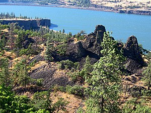
Mosier, Oregon
City in Oregon, United States
Distance: Approx. 2847 meters
Latitude and longitude: 45.685,-121.395
Mosier is a city along the Columbia River in Wasco County, Oregon, United States. The population was 433 at the 2010 census.

Rowena, Oregon
Unincorporated community in the state of Oregon, United States
Distance: Approx. 7722 meters
Latitude and longitude: 45.67,-121.275
Rowena is an unincorporated community in Wasco County, Oregon, United States. For statistical purposes, the United States Census Bureau has defined Rowena as a census-designated place (CDP). The census definition of the area may not precisely correspond to local understanding of the area with the same name.

Lyle, Washington
Census-designated place in Washington, United States
Distance: Approx. 8060 meters
Latitude and longitude: 45.69555556,-121.28055556
Lyle is an unincorporated community and census-designated place (CDP) in Klickitat County, Washington, United States. The population was 518 at the 2020 census.

Klickitat River
River in Washington, United States
Distance: Approx. 7355 meters
Latitude and longitude: 45.69638889,-121.29138889
The Klickitat River is a tributary of the Columbia River, nearly 96 miles (154 km) long, in south-central Washington in the United States. It drains a rugged plateau area on the eastern side of the Cascade Range northeast of Portland, Oregon. In 1986, 10 miles (16 km) of the river were designated Wild and Scenic from the confluence with Wheeler Creek, near the town of Pitt, to the confluence with the Columbia River.

Ortley, Oregon
Distance: Approx. 6735 meters
Latitude and longitude: 45.655953,-121.288128
Ortley is a former town in Wasco County, Oregon, in the United States. It was about 1 mile (2 km) south of Rowena and about 7 miles (11 km) southeast of Mosier; the site is now on private land and no evidence of the townsite exists today.

Eighteenmile Island
Island on the Oregon side of the Columbia River, Oregon, United States
Distance: Approx. 4667 meters
Latitude and longitude: 45.68972222,-121.42138889
Eighteenmile Island is a 9.89 acre (4 ha) island on the Oregon side of the Columbia River at river mile 174 in Wasco County, Oregon, United States. It is about a half mile (0.8 km) downstream of Mosier, Oregon and four miles (6.4 km) upstream of Hood River. It can be seen from Interstate 84, which runs along the Oregon side of the Columbia River, and from the Historic Columbia River Highway.

Mayer State Park
State park in Oregon, United States
Distance: Approx. 8200 meters
Latitude and longitude: 45.675676,-121.2697945
Mayer State Park is a state park in the Columbia River Gorge, near Rowena, Oregon in Wasco County in the U.S. state of Oregon. It consists of several disjointed parcels of transected by Interstate 84 and the tracks of the Union Pacific Railroad. The south-easternmost parcel includes the Rowena Loops, a series of horseshoe curves by which the Historic Columbia River Highway (U.S. Route 30) climbs to the Rowena Crest, where there is an overlook, from the community of Rowena.

Koberg Beach State Recreation Site
Distance: Approx. 7282 meters
Latitude and longitude: 45.6956747,-121.4559063
Koberg Beach State Recreation Site is a state park in Hood River County, Oregon United States, administered by the Oregon Parks and Recreation Department. The park offers a wayside rest area for west bound traffic on Interstate 84. For years, the area was owned by the Koberg family who developed the beach and built a rustic style dance hall which was popular with people from nearby Hood River.
Memaloose State Park
State park in Oregon, United States
Distance: Approx. 4748 meters
Latitude and longitude: 45.6956758,-121.3328503
Memaloose State Park is a state park in the U.S. state of Oregon, 11 miles west of The Dalles and accessible via Interstate 84. Memaloose Island to the north is visible from the state park. Victor Trevitt, an early member of the Oregon Legislative Assembly, was buried on the island after his death in 1883; his grave marker is visible on the southern shore of the island.

KHRV
Radio station in Hood River, Oregon
Distance: Approx. 7636 meters
Latitude and longitude: 45.662,-121.472
KHRV (90.1 FM) is a radio station licensed to Hood River, Oregon. The station is owned by Oregon Public Broadcasting, and airs OPB's news and talk programming, consisting of syndicated programming from NPR, APM and PRX, as well as locally produced offerings.

Jefferson Mosier House
Historic house in Oregon, United States
Distance: Approx. 2614 meters
Latitude and longitude: 45.682287,-121.39516
The Jefferson Mosier House is a historic house in Mosier, Oregon, United States. Jefferson N. Mosier (1860–1928) first platted the town in 1902 on what had been his father's donation land claim, and tirelessly promoted it for decades after. He built this prominent house in 1904, and remained in residence until his death.
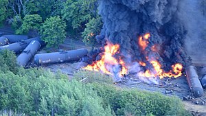
2016 Union Pacific oil train fire
US oil train derailment and fire
Distance: Approx. 3247 meters
Latitude and longitude: 45.6847006,-121.4034557
On June 3, 2016, a Union Pacific train with 96 tank cars carrying Bakken oil from New Town, North Dakota to U.S. Oil and Refining in Tacoma, Washington derailed in the Columbia River Gorge near Mosier, Oregon. Sixteen of the 96 cars derailed after the train's emergency brake system about 18 cars back from the engines engaged - several cars then caught fire. By 5pm large explosions were coming from the tankers.
Weather in this IP's area
snow
-7 Celsius
-12 Celsius
-7 Celsius
-6 Celsius
1006 hPa
89 %
1006 hPa
947 hPa
1609 meters
3.58 m/s
6.26 m/s
40 degree
100 %