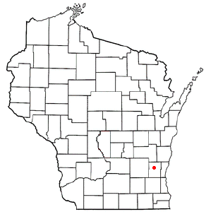
23.170.208.97 - IP Lookup: Free IP Address Lookup, Postal Code Lookup, IP Location Lookup, IP ASN, Public IP
Country:
Region:
City:
Location:
Time Zone:
Postal Code:
IP information under different IP Channel
ip-api
Country
Region
City
ASN
Time Zone
ISP
Blacklist
Proxy
Latitude
Longitude
Postal
Route
Luminati
Country
Region
wi
City
westbend
ASN
Time Zone
America/Chicago
ISP
ETHOPLEX
Latitude
Longitude
Postal
IPinfo
Country
Region
City
ASN
Time Zone
ISP
Blacklist
Proxy
Latitude
Longitude
Postal
Route
IP2Location
23.170.208.97Country
Region
wisconsin
City
west bend
Time Zone
America/Chicago
ISP
Language
User-Agent
Latitude
Longitude
Postal
db-ip
Country
Region
City
ASN
Time Zone
ISP
Blacklist
Proxy
Latitude
Longitude
Postal
Route
ipdata
Country
Region
City
ASN
Time Zone
ISP
Blacklist
Proxy
Latitude
Longitude
Postal
Route
Popular places and events near this IP address

Barton, Wisconsin
Town in Washington County, Wisconsin
Distance: Approx. 3063 meters
Latitude and longitude: 43.45,-88.2
Barton is a town in Washington County, Wisconsin, United States. The population was 2,546 at the 2000 census. The unincorporated community of Young America is located in the town.

West Bend (town), Wisconsin
Town in Washington County, Wisconsin
Distance: Approx. 5096 meters
Latitude and longitude: 43.39583333,-88.23194444
West Bend is a town in Washington County, Wisconsin, United States. The population was 4,834 at the 2000 census. The City of West Bend is located partially within the town.

West Bend, Wisconsin
City and county seat of Washington County, Wisconsin
Distance: Approx. 31 meters
Latitude and longitude: 43.425,-88.18333333
West Bend is a city in and the county seat of Washington County, Wisconsin, United States. As of the 2020 census, the population was 31,752. It is part of the Milwaukee metropolitan area.

Lizard Mound State Park
United States historic place
Distance: Approx. 5560 meters
Latitude and longitude: 43.46333333,-88.13916667
Lizard Mound State Park is a state park in the Town of Farmington, Washington County, Wisconsin near the city of West Bend. The park contains a significant well-preserved effigy mound group, representing one of the largest and best-preserved collections of such mounds in the state. Mounds in the park are the subject of at least two different listings on the National Register of Historic Places, one encompassing the park as a whole, and another which includes a larger set of regional mounds.
West Bend Municipal Airport
Airport
Distance: Approx. 4503 meters
Latitude and longitude: 43.42222222,-88.12805556
West Bend Municipal Airport (IATA: ETB, ICAO: KETB, FAA LID: ETB) is a city-owned public-use airport located three nautical miles (6 km) east of the central business district of West Bend, a city in Washington County, Wisconsin, United States. It is included in the Federal Aviation Administration (FAA) National Plan of Integrated Airport Systems for 2025–2029, in which it is categorized as a regional reliever airport facility.
University of Wisconsin–Milwaukee at Washington County
College in West Bend, Wisconsin, U.S.
Distance: Approx. 2449 meters
Latitude and longitude: 43.41861111,-88.2125
The University of Wisconsin–Milwaukee at Washington County was a campus of the College of General Studies, University of Wisconsin-Milwaukee, and is located in West Bend, Wisconsin, United States. In 2018, the college became a regional campus of the University of Wisconsin-Milwaukee. The campus closed on June 30, 2024, as part of a larger cut in regional campuses throughout the University of Wisconsin system.

Museum of Wisconsin Art
Art museum in West Bend, Wisconsin
Distance: Approx. 178 meters
Latitude and longitude: 43.425,-88.18141667
The Museum of Wisconsin Art (formerly the West Bend Art Museum) is a museum that collects and exhibits contemporary and historical art from the state of Wisconsin. Its collections include rotating historical and contemporary exhibitions and educational programs. The museum's One Gallery features solo shows of contemporary Wisconsin artists and arts organizations several times each year.

Young America, Wisconsin
Unincorporated community in Wisconsin, United States
Distance: Approx. 2952 meters
Latitude and longitude: 43.45166667,-88.18583333
Young America is an unincorporated community located in the town of Barton, Washington County, Wisconsin, United States.

Washington County Courthouse and Jail
United States historic place
Distance: Approx. 583 meters
Latitude and longitude: 43.42,-88.18277778
The Washington County Courthouse and Jail in West Bend, Wisconsin is the historic former courthouse of Washington County, Wisconsin. It now holds the Tower Heritage Center, a museum and research center operated by the Washington County Historical Society. The building was listed on the National Register of Historic Places in 1982.

Gadow's Mill
United States historic place
Distance: Approx. 1936 meters
Latitude and longitude: 43.4425,-88.18111111
Gadow's Mill (Barton Roller Mills) is a former grist mill on the Milwaukee River in West Bend, Wisconsin, United States, that is listed on the National Register of Historic Places (NRHP).

Barton Historic District
United States historic place
Distance: Approx. 1842 meters
Latitude and longitude: 43.4417,-88.1819
The Barton Historic District is a historic district in West Bend, Wisconsin. Now engulfed by West Bend, the modest former village of Barton retains survivors from its early frontier days. Includes the 1850 gabled-ell Hays-Raif house, the 1865 Barton Roller Mill, the 1865 Frazer General Store, the 1865 Greek Revival Frazer House, the 1900 Gothic Revival St Mary's church, the 1915 Barton Bank, the 1921 Ustruck bungalow, and the 1928 French Revival Kircher house.

West Bend station
Historic railroad in West Bend, Wisconsin
Distance: Approx. 218 meters
Latitude and longitude: 43.42444444,-88.18111111
The West Bend station, otherwise known as the West Bend Chicago and North Western Depot is a historic railroad station in West Bend, Wisconsin. The depot was designed in 1900 by the firm Frost and Granger in the Craftsman style for the Chicago and North Western Railway (C&NW). It is a variation of the C&NW "Number One" combination depot design.
Weather in this IP's area
fog
5 Celsius
5 Celsius
4 Celsius
7 Celsius
1019 hPa
95 %
1019 hPa
985 hPa
402 meters
0.45 m/s
0.45 m/s
174 degree
100 %