Country:
 USA
USARegion:
City:
Latitude and Longitude:
Time Zone:
Postal Code:
IP information under different IP Channel
ip-api
Country
Region
City
ASN
Time Zone
ISP
Blacklist
Proxy
Latitude
Longitude
Postal
Route
IPinfo
Country
Region
City
ASN
Time Zone
ISP
Blacklist
Proxy
Latitude
Longitude
Postal
Route
MaxMind
Country
Region
City
ASN
Time Zone
ISP
Blacklist
Proxy
Latitude
Longitude
Postal
Route
Luminati
Country
USRegion
wa
City
almira
ASN
Time Zone
America/Los_Angeles
ISP
NORTH-RIDGE
Latitude
Longitude
Postal
db-ip
Country
Region
City
ASN
Time Zone
ISP
Blacklist
Proxy
Latitude
Longitude
Postal
Route
ipdata
Country
Region
City
ASN
Time Zone
ISP
Blacklist
Proxy
Latitude
Longitude
Postal
Route
Popular places and events near this IP address

Banks Lake South, Washington
Census-designated place in Washington, United States
Distance: Approx. 3641 meters
Latitude and longitude: 47.63027778,-119.275
Banks Lake South is a census-designated place (CDP) in Grant County, Washington, United States. The population was 234 at the 2020 census.

Coulee City, Washington
Town in Washington, United States
Distance: Approx. 2084 meters
Latitude and longitude: 47.61194444,-119.29083333
Coulee City is a town in Grant County, Washington. The population was 549 at the 2020 census.
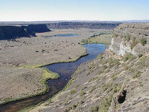
Grand Coulee
Ancient river bed in the U.S. state of Washington
Distance: Approx. 3595 meters
Latitude and longitude: 47.62,-119.3075
Grand Coulee is an ancient river bed in the U.S. state of Washington. This National Natural Landmark stretches for about 60 miles (100 km) southwest from Grand Coulee Dam to Soap Lake, being bisected by Dry Falls into the Upper and Lower Grand Coulee.

Dry Falls
Scalloped precipice with four major alcoves, in central Washington scablands
Distance: Approx. 6307 meters
Latitude and longitude: 47.6,-119.35694444
Dry Falls is a 3.5-mile-long (5.6 km) scalloped precipice with four major alcoves, in central Washington scablands. This cataract complex is on the opposite side of the Upper Grand Coulee from the Columbia River, and at the head of the Lower Grand Coulee, northern end of Lenore Canyon. According to the current geological model, catastrophic flooding channeled water at 65 miles per hour (105 kph) through the Upper Grand Coulee and over this 400-foot (120 m) rock face at the end of the last glaciation.
Sun Lakes-Dry Falls State Park
State park in Washington State, United States
Distance: Approx. 6935 meters
Latitude and longitude: 47.59472222,-119.36527778
Sun Lakes-Dry Falls State Park (formerly, Sun Lakes State Park) is a public recreation area located at the foot of Dry Falls, three miles (4.8 km) west of Coulee City in Grant County, Washington. The state park covers 3,774 acres (1,527 ha) along Route 17 at the head of the Lower Grand Coulee.
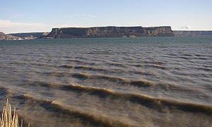
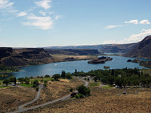
Banks Lake
Reservoir in Washington, United States
Distance: Approx. 3595 meters
Latitude and longitude: 47.62,-119.3075
Banks Lake is a 27-mile-long (43 km) reservoir in central Washington in the United States. Part of the Columbia Basin Project, Banks Lake occupies the northern portion of the Grand Coulee, a formerly dry coulee near the Columbia River, formed by the Missoula Floods during the Pleistocene epoch. Grand Coulee Dam, built by the United States Bureau of Reclamation on the Columbia River created Franklin D. Roosevelt Lake, the reservoir on the river behind the dam.
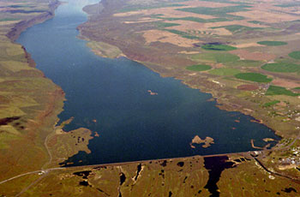
Dry Falls Dam
Dam in Washington, USA
Distance: Approx. 3595 meters
Latitude and longitude: 47.62,-119.3075
Dry Falls Dam is a rockfaced earthfill type dam in the U.S. state of Washington. Located in Grant County near Coulee City, it was built as part of the Bureau of Reclamation's Columbia Basin Project. Water from the Columbia River, impounded by Grand Coulee Dam, is pumped into Grand Coulee, a formerly dry canyon, through the short Feeder Canal.
Weather in this IP's area
clear sky
3 Celsius
3 Celsius
1 Celsius
3 Celsius
1024 hPa
83 %
1024 hPa
960 hPa
10000 meters
0.89 m/s
1.17 m/s
29 degree
6 %
07:26:49
17:55:49