23.165.137.14 - IP Lookup: Free IP Address Lookup, Postal Code Lookup, IP Location Lookup, IP ASN, Public IP
Country:
Region:
City:
Location:
Time Zone:
Postal Code:
IP information under different IP Channel
ip-api
Country
Region
City
ASN
Time Zone
ISP
Blacklist
Proxy
Latitude
Longitude
Postal
Route
Luminati
Country
ASN
Time Zone
America/Chicago
ISP
X6CNET
Latitude
Longitude
Postal
IPinfo
Country
Region
City
ASN
Time Zone
ISP
Blacklist
Proxy
Latitude
Longitude
Postal
Route
IP2Location
23.165.137.14Country
Region
west virginia
City
teays valley
Time Zone
America/New_York
ISP
Language
User-Agent
Latitude
Longitude
Postal
db-ip
Country
Region
City
ASN
Time Zone
ISP
Blacklist
Proxy
Latitude
Longitude
Postal
Route
ipdata
Country
Region
City
ASN
Time Zone
ISP
Blacklist
Proxy
Latitude
Longitude
Postal
Route
Popular places and events near this IP address
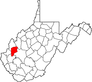
Putnam County, West Virginia
County in West Virginia, United States
Distance: Approx. 8480 meters
Latitude and longitude: 38.51,-81.91
Putnam County is a county in the U.S. state of West Virginia. As of the 2020 census, the population was 57,440. Its county seat is Winfield, its largest incorporated city is Hurricane, and its largest community is the census-designated place of Teays Valley.
Teays, West Virginia
Unincorporated community in West Virginia, United States
Distance: Approx. 28 meters
Latitude and longitude: 38.44166667,-81.95277778
Teays, written Seays until circa 1884, is an unincorporated community in Putnam County, West Virginia, United States. The town is centered on the former general store / post office on Teays Lane, which sits across from the site of the Teays railroad depot, which was demolished in the mid-1900s. Teays is a namesake and part of the census-designated place of Teays Valley, which was in turn named for Thomas Teays, a hunter and trapper who once spent a considerable amount of time in the vicinity.

Hurricane, West Virginia
City in West Virginia, United States
Distance: Approx. 5899 meters
Latitude and longitude: 38.4325,-82.01972222
Hurricane ( HUR-uh-kin) is a city in Putnam County, West Virginia, United States. The population was 6,977 at the 2020 census. Located roughly equidistant from Charleston and Huntington, it is part of the Huntington–Ashland metropolitan area.

Teays Valley, West Virginia
Census-designated place in West Virginia, United States
Distance: Approx. 1515 meters
Latitude and longitude: 38.44722222,-81.93722222
Teays Valley ( TAYZ) is a census-designated place in Putnam County, West Virginia, United States. The population was 14,350 at the 2020 census. Located about 20 miles (32 km) west of Charleston and 30 miles (48 km) east of Huntington, it is part of the Huntington–Ashland metropolitan area.
Hurricane High School (West Virginia)
Public high school in Hurricane, West Virginia, United States
Distance: Approx. 4602 meters
Latitude and longitude: 38.4377,-82.00563
Hurricane High School is a public high school located in Hurricane, West Virginia, United States. It serves students in grades 9 through 12 and is one of four high schools operated by Putnam County Schools.
Scott Depot, West Virginia
Unincorporated community in West Virginia, United States
Distance: Approx. 3664 meters
Latitude and longitude: 38.44722222,-81.91166667
Scott Depot is an unincorporated community in Putnam County, West Virginia, United States. Located along Crooked Creek, it is part of the census-designated place of Teays Valley, which is a part of the Huntington–Ashland metropolitan area. The ZIP code is 25560.

Mount Vernon, West Virginia
Unincorporated community in West Virginia, United States
Distance: Approx. 1435 meters
Latitude and longitude: 38.44888889,-81.93944444
Mt. Vernon is an unincorporated community in Putnam County, West Virginia, United States. It is part of the census-designated place of Teays Valley.

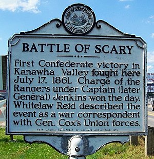
Battle of Scary Creek
Battle of the American Civil War
Distance: Approx. 8749 meters
Latitude and longitude: 38.43333333,-81.85333333
The Battle of Scary Creek was a minor battle fought on July 17, 1861 during the American Civil War in Scary across the Kanawha River from present day Nitro in Putnam County, West Virginia. It was the first Confederate victory in Kanawha Valley.
WPJW
Radio station in Hurricane, West Virginia
Distance: Approx. 5407 meters
Latitude and longitude: 38.44472222,-82.015
WPJW (91.5 FM, "WALK FM") is a radio station broadcasting a Christian adult contemporary music format. One of the 7 "WALK FM" network of stations. Licensed to Hurricane, West Virginia, United States, the station is currently owned by Positive Alternative Radio, Inc.
Asbury House
Historic house in West Virginia, United States
Distance: Approx. 5802 meters
Latitude and longitude: 38.43388889,-82.01888889
Asbury House is a historic home located at Hurricane, Putnam County, West Virginia. It was built about 1876, and is a two-story brick dwelling in the Greek Revival / I house style. It features a reconstructed small front portico with metal hip roof and columns.
Cheyenne Valley, West Virginia
Unincorporated community in West Virginia, United States
Distance: Approx. 1212 meters
Latitude and longitude: 38.45138889,-81.95944444
Cheyenne Valley is an unincorporated community in Putnam County, West Virginia, United States.
Cherry Grove, Putnam County, West Virginia
Unincorporated community in West Virginia, United States
Distance: Approx. 2728 meters
Latitude and longitude: 38.43944444,-81.92194444
Cherry Grove is an unincorporated community in Putnam County, West Virginia, United States.
Weather in this IP's area
broken clouds
4 Celsius
4 Celsius
4 Celsius
6 Celsius
1023 hPa
96 %
1023 hPa
996 hPa
10000 meters
1.34 m/s
1.34 m/s
118 degree
59 %

