23.154.18.66 - IP Lookup: Free IP Address Lookup, Postal Code Lookup, IP Location Lookup, IP ASN, Public IP
Country:
Region:
City:
Location:
Time Zone:
Postal Code:
ISP:
ASN:
language:
User-Agent:
Proxy IP:
Blacklist:
IP information under different IP Channel
ip-api
Country
Region
City
ASN
Time Zone
ISP
Blacklist
Proxy
Latitude
Longitude
Postal
Route
db-ip
Country
Region
City
ASN
Time Zone
ISP
Blacklist
Proxy
Latitude
Longitude
Postal
Route
IPinfo
Country
Region
City
ASN
Time Zone
ISP
Blacklist
Proxy
Latitude
Longitude
Postal
Route
IP2Location
23.154.18.66Country
Region
florida
City
tampa
Time Zone
America/New_York
ISP
Language
User-Agent
Latitude
Longitude
Postal
ipdata
Country
Region
City
ASN
Time Zone
ISP
Blacklist
Proxy
Latitude
Longitude
Postal
Route
Popular places and events near this IP address

Tampa, Florida
City in Florida, United States
Distance: Approx. 21 meters
Latitude and longitude: 27.9475,-82.45861111
Tampa ( TAM-pə) is a city on the Gulf Coast of the U.S. state of Florida. Tampa's borders include the north shore of Tampa Bay and the east shore of Old Tampa Bay. Tampa is the largest city in the Tampa Bay area and the county seat of Hillsborough County.

Tampa Police Department
Law enforcement agency in Florida, US
Distance: Approx. 100 meters
Latitude and longitude: 27.948307,-82.457946
The Tampa Police Department (TPD) is the primary law enforcement agency for the city of Tampa, Florida. The Tampa Police Department has 985 authorized sworn law enforcement personnel positions and more than 350 civilian and support staff personnel positions. The current police chief is Lee Bercaw.

2002 Tampa Cessna 172 crash
Intentional aircraft crash
Distance: Approx. 81 meters
Latitude and longitude: 27.947,-82.459
On January 5, 2002, Charles J. Bishop, a high-school student of East Lake High School in Tarpon Springs, Florida, United States, stole a Cessna 172 light aircraft and crashed it into the side of the Bank of America Tower in downtown Tampa, Florida. The impact killed the teenager and damaged an office room, but there were no other injuries. Bishop had been inspired by the September 11 attacks; he had left a suicide note crediting Osama bin Laden for the attacks and praising it as a justified response to actions against the Palestinians and Iraqis and said he (Bishop) was acting on behalf of Al Qaeda, from whom he had turned down help.

Tampa City Hall
United States historic place
Distance: Approx. 94 meters
Latitude and longitude: 27.94722222,-82.4575
The Tampa City Hall is a historic site in Tampa, Florida, United States. It was designed by Bonfoey & Elliott and is located at 315 East John F. Kennedy Boulevard. It was documented by the Historic American Buildings Survey in 1981.

Bank of America Plaza (Tampa)
42-story skyscraper located in Downtown Tampa
Distance: Approx. 132 meters
Latitude and longitude: 27.9466,-82.45928
The Bank of America Plaza is a 42-story skyscraper located in Downtown Tampa, in the U.S. state of Florida, and was completed in 1986. At 175.87 m (577.0 ft), it surpassed One Tampa City Center as the tallest building in Tampa, until completion of 100 North Tampa in 1992. The structure was originally known as Barnett Plaza.

One Tampa City Center
Office skyscraper in Tampa, Florida
Distance: Approx. 156 meters
Latitude and longitude: 27.94694444,-82.45694444
One Tampa City Center, formerly known as GTE Center and Verizon Building, is an office skyscraper in Tampa, Florida. It was the tallest building in the state for three years and the tallest building in the city until the completion of the Bank of America tower in 1986. At 39 stories, it is currently the third tallest structure in the city, standing 537 feet (164 m) tall.

Fifth Third Center (Tampa)
279 ft (85m) high rise in Tampa, Florida
Distance: Approx. 24 meters
Latitude and longitude: 27.9473,-82.4583
Fifth Third Center is a 279 ft (85m) high rise in Tampa, Florida. It was completed in 1981 and has 19 floors. HKS, Inc.

Rivergate Tower
Skyscraper in Tampa, Florida
Distance: Approx. 221 meters
Latitude and longitude: 27.94731,-82.460632
The Rivergate Tower, also known as the Sykes building or the Beer Can Building, is a 454-foot-tall (138 m) skyscraper in Tampa, Florida. The skyscraper is the seventh tallest building in Tampa with 31 floors. Rivergate Tower's principal tenant is Sykes Enterprises, a publicly-traded company that operates technical help and customer support centers internationally.

Truist Place
Skyscraper in Tampa, Florida
Distance: Approx. 233 meters
Latitude and longitude: 27.94694444,-82.45611111
Truist Place, formerly SunTrust Financial Centre, is a 525 ft (160 m) skyscraper in Tampa, Florida. It was completed in 1992 and has 36 floors. Cooper Carry designed the building, which is the 4th tallest in Tampa.
Courier City-Oscawana
Neighborhood in Hillsborough, Florida, United States
Distance: Approx. 120 meters
Latitude and longitude: 27.94666667,-82.45916667
Courier City-Oscawana is a neighborhood within the city limits of Tampa, Florida. As of the 2000 census the neighborhood had a population of 1,531. The ZIP Codes serving the neighborhood are 33606 and 33609.

Old Hillsborough County Courthouse
Distance: Approx. 214 meters
Latitude and longitude: 27.94846,-82.45652
The Hillsborough County Courthouse was constructed in 1892 in the block bounded by Madison Street, Lafayette Street (now Kennedy Boulevard), Florida Avenue, and Franklin Street. This replaced an older courthouse in the same place. Designed by John A. Wood, it included some of the Moorish architectural styles and domes similar to the Tampa Bay Hotel, which was also designed by Wood, across the Hillsborough River.

Mercantile Bank building (Tampa, Florida)
Distance: Approx. 175 meters
Latitude and longitude: 27.94680556,-82.46
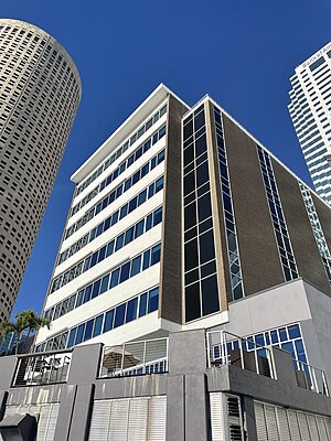
The Mercantile Bank building is an example of modern architecture located in Tampa, Florida. The building is located at 100 West Kennedy Boulevard and overlooks the Hillsborough River including an unobstructed view of the Tampa Bay Hotel building that is now part of the University of Tampa. In 2012 it was purchased for a planned remodelling to adapt it for use as a boutique hotel.
Weather in this IP's area
overcast clouds
7 Celsius
4 Celsius
6 Celsius
10 Celsius
1024 hPa
83 %
1024 hPa
1022 hPa
10000 meters
5.14 m/s
350 degree
100 %