23.137.168.242 - IP Lookup: Free IP Address Lookup, Postal Code Lookup, IP Location Lookup, IP ASN, Public IP
Country:
Region:
City:
Location:
Time Zone:
Postal Code:
IP information under different IP Channel
ip-api
Country
Region
City
ASN
Time Zone
ISP
Blacklist
Proxy
Latitude
Longitude
Postal
Route
Luminati
Country
Region
mn
City
rushcity
ASN
Time Zone
America/Chicago
ISP
STALWART-ASN-01
Latitude
Longitude
Postal
IPinfo
Country
Region
City
ASN
Time Zone
ISP
Blacklist
Proxy
Latitude
Longitude
Postal
Route
IP2Location
23.137.168.242Country
Region
minnesota
City
roseville
Time Zone
America/Chicago
ISP
Language
User-Agent
Latitude
Longitude
Postal
db-ip
Country
Region
City
ASN
Time Zone
ISP
Blacklist
Proxy
Latitude
Longitude
Postal
Route
ipdata
Country
Region
City
ASN
Time Zone
ISP
Blacklist
Proxy
Latitude
Longitude
Postal
Route
Popular places and events near this IP address

Falcon Heights, Minnesota
City in Minnesota, United States
Distance: Approx. 640 meters
Latitude and longitude: 44.99,-93.17694444
Falcon Heights is a suburb of Saint Paul and a city in Ramsey County, Minnesota, United States. The population was 5,369 at the 2020 census. It became a village on April 1, 1949, and a city in 1973.

KBEM-FM
Radio station in Minneapolis, Minnesota
Distance: Approx. 704 meters
Latitude and longitude: 44.998,-93.189
KBEM-FM (88.5 FM, "Jazz88") is a public radio station broadcasting a jazz format based in Minneapolis, Minnesota, United States, the station serves the Minneapolis-St. Paul area. The station is operated by the Minneapolis Public Schools system and has been partnering since 1989 with the Minnesota Department of Transportation (Mn/DOT), providing traffic congestion reports for commuters in the Minneapolis-St.

KUOM
College radio station of the University of Minnesota Twin Cities
Distance: Approx. 679 meters
Latitude and longitude: 44.99833333,-93.18833333
KUOM (770 AM) – branded Radio K - Real College Radio – is a daytime-only, non-commercial, college radio station licensed to Minneapolis, Minnesota. Owned by the University of Minnesota, Twin Cities, the station is operated by students and faculty. It mainly airs alternative rock with other genres of music.

Les Bolstad Golf Course
Distance: Approx. 1210 meters
Latitude and longitude: 44.992184,-93.196087
Les Bolstad Golf Course is a golf course owned by the University of Minnesota. The course is located in Falcon Heights, Minnesota on the St. Paul Campus of the University.

Elizabeth Lyle Robbie Stadium
Soccer stadium in Minnesota, US
Distance: Approx. 586 meters
Latitude and longitude: 44.99444444,-93.18861111
Elizabeth Lyle Robbie Stadium is a soccer-specific stadium located in Falcon Heights on the Saint Paul campus of the University of Minnesota. It is primarily used as the home of the Minnesota Golden Gophers' women's soccer team. The stadium opened in 1999 and seats 1,000.

Bell Museum of Natural History
Natural history museum of the University of Minnesota
Distance: Approx. 666 meters
Latitude and longitude: 44.99138889,-93.18805556
The Bell Museum, formerly known as the James Ford Bell Museum of Natural History, is located at the University of Minnesota's Saint Paul campus. The museum's current location on the Saint Paul campus opened in 2018. The Minnesota wildlife dioramas focus on animal specimens native to the state.

Gibbs Museum of Pioneer and Dakotah Life
United States historic place
Distance: Approx. 636 meters
Latitude and longitude: 44.99222222,-93.18833333
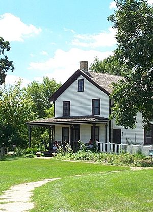
The Gibbs Farm is a museum in Falcon Heights, Minnesota, United States. The site was once the farmstead of Heman and Jane Gibbs, first built in 1854; the existing farmhouse includes the small, original cabin. The museum seeks to educate visitors on the lives of 19th-century Minnesota pioneers and the Dakota people who lived in southern Minnesota before the arrival of Europeans.

Polar Geospatial Center
Distance: Approx. 1182 meters
Latitude and longitude: 44.984308,-93.182207
The Polar Geospatial Center is a research center at the University of Minnesota's College of Science and Engineering funded by the National Science Foundation's Office of Polar Programs. Founded in 2007, the Polar Geospatial Center "provides geospatial support, mapping, and GIS/remote sensing solutions to researchers and logistics groups in the polar science community." It is currently directed by Paul Morin.

University Grove, Minnesota
Distance: Approx. 1131 meters
Latitude and longitude: 44.9891,-93.193
University Grove is a neighborhood of Falcon Heights, Minnesota, known for its 103 homes individually designed by architects. Owners have been required to use an architect since the neighborhood's creation by the University of Minnesota in 1928 to recruit and retain faculty; there is also a cap on costs, ensuring that homes would be of similar size.: 205 To balance the individuality of professors/administrators while keeping the properties in the intended group of buyers, each faculty/staff person owns the homes while the university owns the land upon which the home is situated and the faculty/staff person pays rent annually for that land use. The university retains title to the land.

Goldstein Museum of Design
Design museum in Minnesota, United States
Distance: Approx. 1100 meters
Latitude and longitude: 44.98513889,-93.18333333
The Goldstein Museum of Design (GMD) is a museum on the St. Paul campus of the University of Minnesota. It is part of the university's College of Design.

Killing of Philando Castile
2016 police killing in Falcon Heights
Distance: Approx. 852 meters
Latitude and longitude: 44.99166667,-93.17138889
On July 6, 2016, Philando Castile, a 32-year-old African American man, was fatally shot during a traffic stop by police officer Jeronimo Yanez of the St. Anthony police department in the Minneapolis–Saint Paul metropolitan area. About 9 p.m., Castile was driving with his girlfriend, Diamond Reynolds, and her four-year-old daughter, when he was pulled over by Yanez and another officer in Falcon Heights, a suburb of Saint Paul, Minnesota.
Snelling & Larpenteur station
Bus station in Falcon Heights, Minnesota, United States
Distance: Approx. 1199 meters
Latitude and longitude: 44.99166667,-93.16666667
Snelling & Larpenteur is a bus rapid transit station on the A Line in Falcon Heights, Minnesota, United States. The station is located at the intersection of Larpenteur Avenue on Snelling Avenue. Both station platforms are located far-side of Larpenteur Avenue.
Weather in this IP's area
clear sky
-9 Celsius
-16 Celsius
-10 Celsius
-8 Celsius
1030 hPa
35 %
1030 hPa
991 hPa
10000 meters
6.17 m/s
8.75 m/s
350 degree