Country:
 USA
USARegion:
City:
Latitude and Longitude:
Time Zone:
Postal Code:
IP information under different IP Channel
ip-api
Country
Region
City
ASN
Time Zone
ISP
Blacklist
Proxy
Latitude
Longitude
Postal
Route
IPinfo
Country
Region
City
ASN
Time Zone
ISP
Blacklist
Proxy
Latitude
Longitude
Postal
Route
MaxMind
Country
Region
City
ASN
Time Zone
ISP
Blacklist
Proxy
Latitude
Longitude
Postal
Route
Luminati
Country
USRegion
co
City
denver
ASN
Time Zone
America/Denver
ISP
TIGGEE
Latitude
Longitude
Postal
db-ip
Country
Region
City
ASN
Time Zone
ISP
Blacklist
Proxy
Latitude
Longitude
Postal
Route
ipdata
Country
Region
City
ASN
Time Zone
ISP
Blacklist
Proxy
Latitude
Longitude
Postal
Route
Popular places and events near this IP address

Daniels & Fisher Tower
United States historic place
Distance: Approx. 200 meters
Latitude and longitude: 39.74833333,-104.99527778
The Daniels & Fisher Tower is a distinctive historic landmark located in Denver, Colorado.
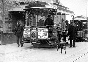
Denver Tramway
Streetcar system in Denver, Colorado, US
Distance: Approx. 163 meters
Latitude and longitude: 39.751,-104.9942
The Denver Tramway, operating in Denver, Colorado, was a streetcar system incorporated in 1886. The tramway was unusual for a number of reasons: the term "tramway" is generally not used in the United States, and it is not known why the company was named as such. The track was 3 ft 6 in (1,067 mm) narrow gauge, an unusual gauge in the United States (although streetcars in Los Angeles also used this gauge), but in general use by railways in Japan, southern Africa, New Zealand, and Queensland, Australia.
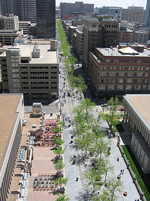
16th Street Mall
Pedestrian and transit mall in Denver, Colorado, United States
Distance: Approx. 185 meters
Latitude and longitude: 39.74861111,-104.99666667
The 16th Street Mall is a pedestrian and transit mall in Denver, Colorado that opened in 1982. The mall, 1.25 miles (2 kilometers) long, runs along 16th Street in downtown Denver, from Wewatta Street (at Union Station) to the intersection of 16th Avenue and Broadway (at Civic Center Station). The intricate granite stone sidewalks and streets were designed by architect I.M Pei to resemble the scale pattern of the western diamondback rattlesnake.

Sakura Square
Distance: Approx. 281 meters
Latitude and longitude: 39.7519,-104.9934
Sakura Square (Japanese: サクラ・スクエア, Sakura Sukuea) is a small plaza located on the north/east side of the intersection of 19th Street and Larimer Street in Denver, Colorado. The square contains busts of Ralph L. Carr, Governor of Colorado from 1939 to 1943, Minoru Yasui, a Japanese-American lawyer, and Yoshitaka Tamai (1900–1983), a Buddhist priest who lived in Denver. Sakura Square also has a small Japanese garden, and it serves as the entrance to the 20-story Tamai Tower apartment building that occupies most of the block.

Denver City Cable Railway Building
United States historic place
Distance: Approx. 168 meters
Latitude and longitude: 39.75053333,-104.99381389
The Denver City Cable Railway Building on Lawrence Street in Denver, Colorado, opened in 1889. Originally built to house power and maintenance facilities for Denver's cable car system, it now houses a restaurant and office space. It was added to the National Register of Historic Places in 1979.

One Tabor Center
Skyscraper in Denver, Colorado
Distance: Approx. 110 meters
Latitude and longitude: 39.74916667,-104.99611111
One Tabor Center is a 408 feet (124 m) tall skyscraper in Denver, Colorado. The building was completed in 1984 and has 30 floors. It is the 15th tallest building in Denver.

17th Street Plaza
Skyscraper in Denver, Colorado
Distance: Approx. 41 meters
Latitude and longitude: 39.75027778,-104.99527778
17th Street Plaza is a 438 ft (134 m) tall skyscraper in Denver, Colorado. It was completed in 1982 and has 33 floors, with a total area of 695,000-square-feet. It was designed by Skidmore, Owings & Merrill and Wendel Duchsherer Architects.

1125 17th Street
Skyscraper in Denver, Colorado
Distance: Approx. 120 meters
Latitude and longitude: 39.7497,-104.9944
1125 17th Street (formerly known as the Bank One Tower) is a 363 ft (111 m) tall skyscraper in Denver, Colorado. It was completed in 1980 and has 25 floors, making it the 29th tallest building in Denver.

Barth Hotel
United States historic place
Distance: Approx. 249 meters
Latitude and longitude: 39.75166667,-104.99777778
The Barth Hotel, also known as the Union Warehouse, is located in Denver, Colorado. It was built in 1882 and was added to the National Register of Historic Places in 1982. In 1980, it was the oldest continuously operated hotel in Denver.

Federal Reserve Bank of Kansas City Denver Branch
Distance: Approx. 310 meters
Latitude and longitude: 39.747319,-104.99543
The Federal Reserve Bank of Kansas City Denver Branch is second largest of three branches of the Federal Reserve Bank of Kansas City. The Denver branch opened January 14, 1918 on 17th Street before moving in 1968 to the 16th Street Mall.

Granite Tower (Denver)
Denver skyscraper
Distance: Approx. 306 meters
Latitude and longitude: 39.74988,-104.99214
Granite Tower, formerly Stellar Plaza and Plaza Tower, is located in the Downtown Denver, Colorado, at 1099 18th Street, Denver, CO. 80202. This office tower is part of Denver Place, a two city block mixed-use high-rise complex.
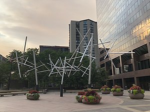
Soft Landing (Snelson)
Sculpture by Kenneth Snelson in Denver, Colorado, U.S.
Distance: Approx. 37 meters
Latitude and longitude: 39.749895,-104.995357
Soft Landing is a 1982 sculpture by Kenneth Snelson, installed at Denver's 17th Street Plaza (1225 17th Street), in the U.S. state of Colorado.
Weather in this IP's area
clear sky
19 Celsius
18 Celsius
15 Celsius
20 Celsius
1015 hPa
48 %
1015 hPa
847 hPa
10000 meters
0.89 m/s
3.13 m/s
100 degree
6 %
06:35:11
19:20:06