223.27.70.109 - IP Lookup: Free IP Address Lookup, Postal Code Lookup, IP Location Lookup, IP ASN, Public IP
Country:
Region:
City:
Location:
Time Zone:
Postal Code:
IP information under different IP Channel
ip-api
Country
Region
City
ASN
Time Zone
ISP
Blacklist
Proxy
Latitude
Longitude
Postal
Route
Luminati
Country
ASN
Time Zone
Asia/Tokyo
ISP
Xserver Inc.
Latitude
Longitude
Postal
IPinfo
Country
Region
City
ASN
Time Zone
ISP
Blacklist
Proxy
Latitude
Longitude
Postal
Route
IP2Location
223.27.70.109Country
Region
kyoto
City
yawata
Time Zone
Asia/Tokyo
ISP
Language
User-Agent
Latitude
Longitude
Postal
db-ip
Country
Region
City
ASN
Time Zone
ISP
Blacklist
Proxy
Latitude
Longitude
Postal
Route
ipdata
Country
Region
City
ASN
Time Zone
ISP
Blacklist
Proxy
Latitude
Longitude
Postal
Route
Popular places and events near this IP address
Yawata
City in Kansai, Japan
Distance: Approx. 1173 meters
Latitude and longitude: 34.87555556,135.7075
Yawata (八幡市, Yawata-shi) is a city located in Kyoto Prefecture, Japan. As of 31 July 2023, the city has an estimated population of 69,306 in 33972 households and a population density of 2800 persons per km2. The total area of the city is 24.35 square kilometres (9.40 sq mi).

Iwashimizu Hachimangū
Distance: Approx. 1416 meters
Latitude and longitude: 34.87972222,135.7
Iwashimizu Hachimangū (石清水八幡宮) is a Shinto shrine in the city of Yawata in Kyoto Prefecture, Japan.

Katsura River
River in Kansai, Japan
Distance: Approx. 2508 meters
Latitude and longitude: 34.880548,135.678056
The Katsura River (桂川, Katsura-gawa) is a continuation of two other rivers, the Hozu River, a small, speedy river which begins in the mountains near Kameoka and then slithers through the mountains separating Kameoka and Kyoto; and the Ōi River (大堰川 Ōi-gawa), which emerges from those mountains and expands into a shallow, slow-flowing river until Togetsukyo Bridge in Arashiyama. From that point forward, the river is referred to as the Katsura River, and its flow continues for several kilometers through Kyoto Prefecture until it joins the Kamo and Uji rivers. The Katsura River area features some of the oldest shrines in Kyoto and Japan, such as Matsuo Shrine, and, as a counterpoint to the channelled Kamo River, supports acres of agricultural area on its flood plain.

Keihan Cable Line
Funicular line in Yawata, Kyoto, Japan
Distance: Approx. 1735 meters
Latitude and longitude: 34.88258333,135.6995
The Iwashimizu-Hachimangū Cable (石清水八幡宮参道ケーブル, Iwashimizu hachmangū sandō kēburu), officially the Keihan Cable Line (京阪鋼索線, Keihan Kōsaku-sen), is a Japanese funicular line in Yawata, Kyoto, operated by Keihan Electric Railway. The line opened in 1926 as a route to Iwashimizu Shrine. Riders in January, the season of hatsumōde (New Year's Day visit to shrine), account for 50% of the whole year ridership.

Kuzuha Station
Railway station in Hirakata, Osaka Prefecture, Japan
Distance: Approx. 2326 meters
Latitude and longitude: 34.86198889,135.67527222
Kuzuha Station (樟葉駅, Kuzuha-eki) is a passenger railway station in located in the city of Hirakata, Osaka Prefecture, Japan, operated by the private railway company Keihan Electric Railway.
Osaka Dental University
Distance: Approx. 2373 meters
Latitude and longitude: 34.85861111,135.67611111
Osaka Dental University (大阪歯科大学, Ōsaka shika daigaku) is a private university in Hirakata, Osaka, Japan. The predecessor of the school was founded in 1911, and it was chartered as a university in 1947. There is a hospital associated with the university located near Temmabashi Station in Chūō-ku, Osaka.

Iwashimizu-hachimangū Station
Railway station in Yawata, Kyoto Prefecture, Japan
Distance: Approx. 1943 meters
Latitude and longitude: 34.88445278,135.70020833
Iwashimizu-hachimangū Station (石清水八幡宮駅, Iwashimizuhachimangu-eki) is a passenger railway station located in the city of Yawata, Kyoto Prefecture, Japan, operated by the private transportation company, Keihan Electric Railway.

Hashimoto Station (Kyoto)
Railway station in Yawata, Kyoto Prefecture, Japan
Distance: Approx. 2185 meters
Latitude and longitude: 34.88166944,135.6841
Hashimoto Station (橋本駅, Hashimoto-eki) is a passenger railway station located in the city of Yawata, Kyoto, Japan, operated by the private transportation company, Keihan Electric Railway.

Cable-hachimangū-sanjō Station
Funicular station in Yawata, Kyoto Prefecture, Japan
Distance: Approx. 1556 meters
Latitude and longitude: 34.880975,135.69982222
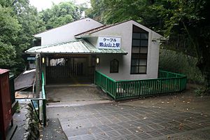
Cable-hachimangū-sanjō Station (ケーブル八幡宮山上駅, Kēburu-hachimangū-sanjō-eki) is a funicular station located in Yawata, Kyoto Prefecture, Japan, on the Keihan Electric Railway Cable Line (Iwashimizu-Hachimangū Cable). Prior to October 2019, the station was referred to as Otokoyama-sanjō Station (男山山上駅, Otokoyama-sanjō-eki).

Minase Shrine
Shinto shrine in Osaka Prefecture, Japan
Distance: Approx. 3170 meters
Latitude and longitude: 34.8849,135.673
Minase Shrine (水無瀬神宮, Minase jingū) is a Shinto Shrine in Shimamoto, Osaka The Shrine is dedicated to the veneration of the kami of Emperor Go-Toba, Emperor Tsuchimikado and Emperor Juntoku. In the struggle with the Kamakura shogunate, the three historical figures are united by one common factor—each was overpowered and banished from the Imperial center in Kyoto: Go-Toba was banished to Oki Island, where he died. Tsuchimikado felt compelled to abandon Kyoto, traveling first to Tosa province (now known as Kōchi Prefecture); and later, he removed himself to Awa province, where he died in exile.
Kuzuha, Hirakata, Osaka
District of Osaka, Japan
Distance: Approx. 2214 meters
Latitude and longitude: 34.8625,135.67638889
Kuzuha (樟葉) is a district of north Hirakata, Osaka, in Japan. It is located approximately 23 minutes by train from Sanjō Keihan Station in Kyoto and approximately 31 minutes from Yodoyabashi Station in Osaka. Since 2004, Kuzuha has seen substantial redevelopment in the immediate station vicinity.

Shōka-dō
Distance: Approx. 1410 meters
Latitude and longitude: 34.87958333,135.70177778
The Shōka-dō (松花堂) is a hermitage built in the early Edo period, located in the city of Yawata, Kyoto, Japan. It was designated as a National Historic Site in 1957 under the name "Shōka-dō and its ruins" and its gardens were designated a National Place of Scenic Beauty under the name "Shōka-dō and Shoin Garden" the same year.
Weather in this IP's area
clear sky
1 Celsius
1 Celsius
1 Celsius
1 Celsius
1019 hPa
92 %
1019 hPa
1008 hPa
10000 meters
0.6 m/s
0.66 m/s
106 degree
3 %

