223.196.187.199 - IP Lookup: Free IP Address Lookup, Postal Code Lookup, IP Location Lookup, IP ASN, Public IP
Country:
Region:
City:
Location:
Time Zone:
Postal Code:
IP information under different IP Channel
ip-api
Country
Region
City
ASN
Time Zone
ISP
Blacklist
Proxy
Latitude
Longitude
Postal
Route
Luminati
Country
Region
ap
City
mangalagiri
ASN
Time Zone
Asia/Kolkata
ISP
Andhra Pradesh State FiberNet Limited
Latitude
Longitude
Postal
IPinfo
Country
Region
City
ASN
Time Zone
ISP
Blacklist
Proxy
Latitude
Longitude
Postal
Route
IP2Location
223.196.187.199Country
Region
telangana
City
hyderabad
Time Zone
Asia/Kolkata
ISP
Language
User-Agent
Latitude
Longitude
Postal
db-ip
Country
Region
City
ASN
Time Zone
ISP
Blacklist
Proxy
Latitude
Longitude
Postal
Route
ipdata
Country
Region
City
ASN
Time Zone
ISP
Blacklist
Proxy
Latitude
Longitude
Postal
Route
Popular places and events near this IP address

Telangana High Court
High Court for the Indian State Telangana
Distance: Approx. 726 meters
Latitude and longitude: 17.369181,78.472039
The Telangana High Court is the High Court for the Indian state of Telangana. Founded by the 7th Nizam of Hyderabad Mir Osman Ali Khan, initially, it was set up as High Court of Hyderabad for the then princely state of Hyderabad Deccan and later renamed High Court of Andhra Pradesh, as it was set up on 5 November 1956 under the States Reorganisation Act, 1956. The Andhra Pradesh High Court was renamed as High Court of Judicature at Hyderabad in view of the bifurcation of Andhra Pradesh state.
Omerkhan Daira
Census town in Telangana, India
Distance: Approx. 0 meters
Latitude and longitude: 17.3753,78.4744
Omerkhan Daira is a census town in Rangareddi district in the Indian state of Telangana.
Osmania General Hospital
Hospital in Telangana, India
Distance: Approx. 370 meters
Latitude and longitude: 17.372,78.474
Osmania General Hospital (OGH) is one of the oldest hospitals in India located at Afzal Gunj, Hyderabad. It is named after its founder – Mir Osman Ali Khan, the last Nizam of Hyderabad. It is run by the Government of Telangana, and is one of the largest healthcare facilities in the state.

Nayapul
Inner city in Telangana, India
Distance: Approx. 550 meters
Latitude and longitude: 17.3707,78.4763
Nayapul (meaning 'new bridge') is a neighbourhood of Hyderabad, Telangana, India. It gets its name from the bridge that was built during the time of the Nizams called as Nayapul because there was already another bridge called Puaranapul.
Begum Bazaar
Commercial market in Hyderabad, India
Distance: Approx. 220 meters
Latitude and longitude: 17.373412,78.473774
Begum Bazaar is the biggest commercial market in Hyderabad, India. It was established during the Qutb Shahi rule. Begum Bazaar is located about a half of a kilometer from the Naya Pul bridge in the Old City.
Afzal Gunj
Neighbourhood in Hyderabad District, Telangana, India
Distance: Approx. 434 meters
Latitude and longitude: 17.373247,78.470932
Afzal Gunj is one of the neighbourhoods located on the border of central Hyderabad and the Old City, Hyderabad, Telangana, India, close to river Musi. Afzal Gunj is the hub of local transportation due to the presence of Central Bus Station in the region. The bus station provides services to most parts of the city.

Badshahi Ashurkhana
Historic site in Hyderabad, India
Distance: Approx. 706 meters
Latitude and longitude: 17.36909,78.475726
Badshahi Ashurkhana is an ashurkhana near Charminar in Hyderabad, India. It was constructed in memory of martyrdom of Imam Hussain, and is used during the mourning period of Moharram.
Akkanna Madanna Temple
Hindu temple in Telangana, India
Distance: Approx. 0 meters
Latitude and longitude: 17.3753,78.4744
Akkanna Madanna Temple is a Hindu temple located in Hyderabad, Telangana, India. It is popular during the festival of Bonalu that is celebrated in the twin cities of Hyderabad and Secunderabad. The temple is known for the Ghatam procession during Bonalu.

State Central Library, Hyderabad
Public library in Hyderabad, India
Distance: Approx. 432 meters
Latitude and longitude: 17.3742,78.4783
The State Central Library Hyderabad, (Telugu: స్టేట్ సెంట్రల్ లైబ్రరీ) (Urdu: کتب خانہ آصفیہ) known as the State Central Library (SCL) earlier known as Kutub Khana Asafia, is a public library in Hyderabad, Telangana. The library was first established in 1891 at a location in Abids where the General Post Office is today situated. The library was shifted to its present location in 1936 and today is one of the most imposing structures in the city.

Nampally Assembly constituency
Constituency of the Telangana legislative assembly in India
Distance: Approx. 702 meters
Latitude and longitude: 17.38,78.47
Nampally Assembly constituency is a constituency of Telangana Legislative Assembly, India. It is one among 15 constituencies in the capital city of Hyderabad. It is part of Secunderabad Lok Sabha constituency.

MG Bus Station metro station
Metro station in Hyderabad, India
Distance: Approx. 670 meters
Latitude and longitude: 17.378055,78.480005
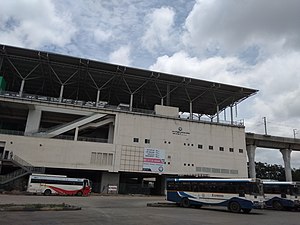
MG Bus Station (MGBS) metro station is an interchange metro station between Red Line and Green Line of the Hyderabad Metro in India. The MG Bus Station Inter-change Metro Station has become one of the largest metro station in Asia, with a sprawling premises over 280,000 square feet (26,000 m2).
Victoria Maternity Hospital, Hyderabad
Hospital in Hyderabad, India
Distance: Approx. 660 meters
Latitude and longitude: 17.369393,78.474956
Victoria Maternity Hospital, also known as Victoria Zenana Hospital, was the second biggest hospital in Hyderabad, India, after Afzalgunj Hospital. The hospital no longer exists and was converted into a block of Telangana High Court to house fire engines. The hospital has been shifted to a new location and today this building is called H-block of the High Court.
Weather in this IP's area
mist
20 Celsius
20 Celsius
20 Celsius
20 Celsius
1019 hPa
77 %
1019 hPa
955 hPa
3000 meters
3.09 m/s
120 degree
40 %