223.196.171.168 - IP Lookup: Free IP Address Lookup, Postal Code Lookup, IP Location Lookup, IP ASN, Public IP
Country:
Region:
City:
Location:
Time Zone:
Postal Code:
ISP:
ASN:
language:
User-Agent:
Proxy IP:
Blacklist:
IP information under different IP Channel
ip-api
Country
Region
City
ASN
Time Zone
ISP
Blacklist
Proxy
Latitude
Longitude
Postal
Route
db-ip
Country
Region
City
ASN
Time Zone
ISP
Blacklist
Proxy
Latitude
Longitude
Postal
Route
IPinfo
Country
Region
City
ASN
Time Zone
ISP
Blacklist
Proxy
Latitude
Longitude
Postal
Route
IP2Location
223.196.171.168Country
Region
andhra pradesh
City
narasapur
Time Zone
Asia/Kolkata
ISP
Language
User-Agent
Latitude
Longitude
Postal
ipdata
Country
Region
City
ASN
Time Zone
ISP
Blacklist
Proxy
Latitude
Longitude
Postal
Route
Popular places and events near this IP address
Matsyapuri
Village in Andhra Pradesh, India
Distance: Approx. 5518 meters
Latitude and longitude: 16.48144,81.626744
Matsyapuri is a Major village in the Veeravasaram mandal of the West Godavari district, near Narsapur, in Andhra Pradesh, India.
Mogalthuru
Village in Andhra Pradesh, India
Distance: Approx. 8029 meters
Latitude and longitude: 16.4167,81.6
Mogalthuru is a village in West Godavari district of the Indian state of Andhra Pradesh. It was a princely estate during the British rule.

Narasapuram Lok Sabha constituency
Lok Sabha Constituency in Andhra Pradesh
Distance: Approx. 6605 meters
Latitude and longitude: 16.4,81.7
Narasapuram Lok Sabha constituency is one of the twenty-five lok sabha constituencies of Andhra Pradesh in India. It comprises seven assembly segments and belongs to West Godavari district.

Narasapuram
Town in Andhra Pradesh, India
Distance: Approx. 4035 meters
Latitude and longitude: 16.4361,81.7016
Narasapuram is a town in West Godavari district of the Indian state of Andhra Pradesh. It is a municipality and mandal headquarters of Narasapuram mandal in Narasapuram revenue division. The city is situated on the banks of the Vasista Godavari River.
Gorintada railway station
Railway station in Andhra Pradesh, India
Distance: Approx. 6377 meters
Latitude and longitude: 16.4913,81.7081
Gorintada railway station (station code: GOTD), is situated on Narasapuram–Bhimavaram branch railway between Narasapuram and Palakollu stations. It is close to National Highway 216 and is a walkable distance from village Digamarru-Kothapeta located on NH 216.

Christ Lutheran Church, Narsapur
Church in India
Distance: Approx. 3402 meters
Latitude and longitude: 16.438,81.696
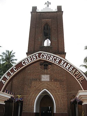
Christ Lutheran Church is a congregation in the Andhra Evangelical Lutheran Church and is a member church of the West Godavari synod. It is a major A class parish and is a mother church to several smaller and younger congregations in and around Narsapur, West Godavari. The current pastors are Rev.
Agarru
Village in Andhra Pradesh, India
Distance: Approx. 5194 meters
Latitude and longitude: 16.49555556,81.67722222
Agarru is a village in Palakol mandal, located in West Godavari district of Andhra Pradesh, India. The nearest railway station is Palakollu train station.
Digamarru
Village in Andhra Pradesh, India
Distance: Approx. 6957 meters
Latitude and longitude: 16.49166667,81.71527778
Digamarru is a village in the West Godavari district in the state of Andhra Pradesh, India. It is close to the city of Palakollu and is located in its mandal.

Ballipadu, Palakol
Village in Andhra Pradesh, India
Distance: Approx. 9234 meters
Latitude and longitude: 16.532493,81.657617
Ballipadu is a village in Palakol mandal, located in West Godavari district of Andhra Pradesh, India. Lankalakoderu and Viravasaram Railway Stations are the nearest railway stations.

Narasapuram Mandal
Mandal in Andhra Pradesh, India
Distance: Approx. 4035 meters
Latitude and longitude: 16.4361,81.7016
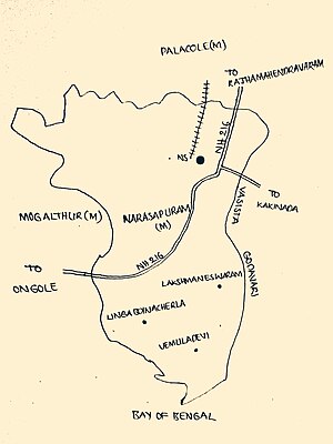
Narasapuram Mandal is one of the 19 mandals in the West Godavari district of the Indian state of Andhra Pradesh. Its headquarters are in Narasapuram, a town in the mandal. The mandal is bordered by the Godavari River to the north, the Bay of Bengal to the east, the Mogalthur mandal to the south, and the Palacole mandal to the west.
Ballipadu, Tallapudi
Village in Andhra Pradesh, India
Distance: Approx. 9146 meters
Latitude and longitude: 16.531577,81.656527
Ballipadu is a village in West Godavari District of Andhra Pradesh, India. It is located in the Thallapudi mandal of Andhra region. It is located 86 km towards east from District headquarters Eluru.
Mogalthur mandal
Mandal in Andhra Pradesh, India
Distance: Approx. 7140 meters
Latitude and longitude: 16.416,81.61
Mogalthur mandal is one of the 19 mandals in the West Godavari district of the Indian state of Andhra Pradesh. It is administered under the Narasapuram revenue division.
Weather in this IP's area
scattered clouds
26 Celsius
26 Celsius
26 Celsius
26 Celsius
1016 hPa
57 %
1016 hPa
1015 hPa
10000 meters
1.46 m/s
2.06 m/s
80 degree
32 %