223.123.104.248 - IP Lookup: Free IP Address Lookup, Postal Code Lookup, IP Location Lookup, IP ASN, Public IP
Country:
Region:
City:
Location:
Time Zone:
Postal Code:
IP information under different IP Channel
ip-api
Country
Region
City
ASN
Time Zone
ISP
Blacklist
Proxy
Latitude
Longitude
Postal
Route
Luminati
Country
Region
sd
City
karachi
ASN
Time Zone
Asia/Karachi
ISP
CMPak Limited
Latitude
Longitude
Postal
IPinfo
Country
Region
City
ASN
Time Zone
ISP
Blacklist
Proxy
Latitude
Longitude
Postal
Route
IP2Location
223.123.104.248Country
Region
sindh
City
mirpur khas
Time Zone
Asia/Karachi
ISP
Language
User-Agent
Latitude
Longitude
Postal
db-ip
Country
Region
City
ASN
Time Zone
ISP
Blacklist
Proxy
Latitude
Longitude
Postal
Route
ipdata
Country
Region
City
ASN
Time Zone
ISP
Blacklist
Proxy
Latitude
Longitude
Postal
Route
Popular places and events near this IP address

Mirpur Khas
City in Sindh, Pakistan
Distance: Approx. 13 meters
Latitude and longitude: 25.525,69.01583333
Mirpur Khas (Sindhi and Urdu: میرپور خاص; meaning "Town of the most-high Mirs") is a city in Sindh province, Pakistan. The city was built by Talpur rulers of Mankani branch. According to the 2017 Census of Pakistan, its population was 205,913.
Mirpur Khas District
District in Sindh, Pakistan
Distance: Approx. 3114 meters
Latitude and longitude: 25.55055556,69.00305556
Mirpur Khas District (Sindhi: ضلعو ميرپورخاص, Urdu: ضلع مِيرپورخاص) is one of the districts of Mirpur Khas Division in the province of Sindh, Pakistan. Its capital is Mirpur Khas city. District Mirpur Khas became district by separating from Tharparkar District on 31 October 1990.

Kahu-Jo-Darro
Distance: Approx. 2401 meters
Latitude and longitude: 25.54565,69.00864
Kahu-Jo-Darro, also known as Mirpur Khas stupa, is an ancient Buddhist stupa found at the Mirpurkhas archaeological site in Sindh, Pakistan. The site is spread over 30 acres (120,000 m2). Excavations completed before 1910 revealed this large brick-based stupa and numerous terracotta reliefs now displayed in major world museums.
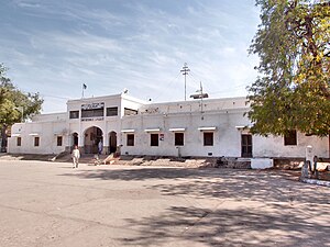
Mirpur Khas railway station
Railway station in Pakistan
Distance: Approx. 131 meters
Latitude and longitude: 25.5251,69.0172
Mirpur Khas Junction Railway Station (Urdu: میرپور خاص ریلوے اسٹیشن,Sindhi: میرپور خاص ریلوي اسٽیشن) is a junction located in the middle of the Mirpur Khas, Sindh, Pakistan on the Hyderabad - Khokhrapar branch railway line. The station is staffed and has a booking office.
Jamrao Halt Junction railway station
Railway station in Pakistan
Distance: Approx. 7987 meters
Latitude and longitude: 25.5241,69.0954
Jamrao Halt Junction Railway Station (Urdu: جمراؤ جنکشن ریلوے اسٹیشن, Sindhi: جمڙائو جنڪشن ريلوي اسٽيشن) is located in Pakistan. The station building is abandoned.
Ratanabad railway station
Railway station in Pakistan
Distance: Approx. 6230 meters
Latitude and longitude: 25.515994,68.954709
Ratanabad railway station (Urdu: رتنا آباد ریلوے اسٹیشن) is located in Pakistan.
St. Teresa's Hospital, Mirpurkhas
Hospital in Mirpurkhas, Sindh, Pakistan
Distance: Approx. 929 meters
Latitude and longitude: 25.527092,69.006924
St. Teresa's Hospital (Urdu: سینٹ ٹریسا ہسپتال میرپورخاص) is a hospital in Mirpurkhas, Sindh, Pakistan.
Weather in this IP's area
clear sky
14 Celsius
12 Celsius
14 Celsius
14 Celsius
1018 hPa
19 %
1018 hPa
1016 hPa
10000 meters
1.65 m/s
1.77 m/s
59 degree

