Country:
Region:
City:
Latitude and Longitude:
Time Zone:
Postal Code:
IP information under different IP Channel
ip-api
Country
Region
City
ASN
Time Zone
ISP
Blacklist
Proxy
Latitude
Longitude
Postal
Route
Luminati
Country
ASN
Time Zone
Asia/Jakarta
ISP
PT NettoCyber Indonesia
Latitude
Longitude
Postal
IPinfo
Country
Region
City
ASN
Time Zone
ISP
Blacklist
Proxy
Latitude
Longitude
Postal
Route
db-ip
Country
Region
City
ASN
Time Zone
ISP
Blacklist
Proxy
Latitude
Longitude
Postal
Route
ipdata
Country
Region
City
ASN
Time Zone
ISP
Blacklist
Proxy
Latitude
Longitude
Postal
Route
Popular places and events near this IP address

2002 Bali bombings
Terrorist attacks in Indonesia
Distance: Approx. 1526 meters
Latitude and longitude: -8.71722222,115.17416667
The 2002 Bali bombings were a series of terrorist attacks that occurred on 12 October 2002, in the tourist district of Kuta on the Indonesian island of Bali. The attacks killed 202 people (including 88 Australians, 38 Indonesians, 23 Britons, and people of more than 20 other nationalities) and a further 209 people were injured. General Da'i Bachtiar, the Indonesian National Police at the time, said that the bombings was the "worst act of terror in Indonesia's history".

Kuta, Bali
Place in Bali, Indonesia
Distance: Approx. 3269 meters
Latitude and longitude: -8.73333333,115.16666667
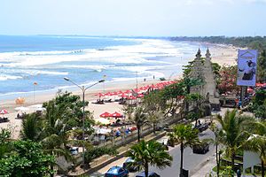
Kuta is a tourist area, administratively an urban village (kelurahan), and the capital of Kuta District, Badung Regency, southern Bali, Indonesia. Kuta is a part of the Denpasar metropolitan area, 12 km (7.5 mi) south of downtown Denpasar. Originally known as a fishing village, it was one of the first towns on Bali to see substantial tourism, and as a beach resort remains one of Indonesia's major tourist destinations.

Legian
Suburban and beach area on Bali, Indonesia
Distance: Approx. 680 meters
Latitude and longitude: -8.70055556,115.165
Legian is a suburban and beach area on the west coast of Bali in Indonesia, just north of Kuta and south of Seminyak, the area between Jl. Melasti and Jl. Dhyana Pura.

Kerobokan Prison
Prison on Bali, Indonesia
Distance: Approx. 3499 meters
Latitude and longitude: -8.67277778,115.16805556
Kerobokan Penitentiary Institution (Indonesian: Lembaga Pemasyarakatan Kerobokan, also known as LP Kerobokan, Kerobokan Prison or Hotel K) is a prison located in Kerobokan, Badung Regency, on the Indonesian island of Bali. Located 4 km (2.49 miles) away from the Canggu village, the prison opened in 1979 and was built to hold 300 inmates. As of 2017, the Kerobokan Prison contains over 1,400 male and female prisoners of various nationalities.
Ujung
Place in Bali, Indonesia
Distance: Approx. 3583 meters
Latitude and longitude: -8.71666667,115.2
Ujung is a village in Bali in the Lesser Sunda Islands of Indonesia. It is located 1.8 miles (2.9 km) outside Kuta on the south coast of the island . Nearby towns and villages include Tuban (1.5 nm), Pesanggaran (1.1 nm), Serangan (1.6 nm), Jimbaran (2.5 nm) and Benoa (2.1 nm).
Pesanggaran
Place in Bali, Indonesia
Distance: Approx. 3583 meters
Latitude and longitude: -8.71666667,115.2
Pesanggaran is a village in Bali in the Lesser Sunda Islands of Indonesia. It is located 3 miles (4.8 km) outside Kuta on the south coast of the island. Nearby towns and villages include Denpasar (4.0 nm), Pabeansanur (2.8 nm), Sanur (2.8 nm), Serangan (1.1 nm) and Ujung (1.1 nm).

Kerobokan
Village in Bali, Indonesia
Distance: Approx. 3512 meters
Latitude and longitude: -8.67277778,115.16666667
Kerobokan is a kelurahan (administrative village) in North Kuta district, Badung Regency, Bali, Indonesia. Kerobokan Prison is located there. It is boxed in by the Seminyak/Oberoi, Umalas/Canggu, and Denpasar regions.
Tuban, Kuta
Distance: Approx. 4373 meters
Latitude and longitude: -8.74277778,115.17722222
Tuban, Kuta is a village in Badung Regency, Bali, Indonesia. It is served by Ngurah Rai International Airport, with Kelan bordering south. Kelan is a part of Tuban subdistricts, Kuta District, Badung, Bali.

Lycée Français de Bali
School in Indonesia
Distance: Approx. 4210 meters
Latitude and longitude: -8.669106,115.155619
Lycée Français de Bali Louis Antoine de Bougainville (LFB, Indonesian: Sekolah Perancis Bali), also known as the École Internationale Française de Bali (EIFB) before 2016, is a French international school in Kerobokan, Bali, Indonesia. It serves maternelle (preschool) through the terminale (final year) of the lycée (senior high school). The school first opened on 1 September 1991.

Ngurah Rai International Airport
Airport in Denpasar, Bali, Indonesia
Distance: Approx. 4895 meters
Latitude and longitude: -8.74805556,115.1675
I Gusti Ngurah Rai International Airport (IATA: DPS, ICAO: WADD), also known as Denpasar International Airport, is the main international airport of Bali, Indonesia. Located 13 kilometres (8.1 mi) from Downtown Denpasar, it serves the Denpasar metropolitan area and the whole island of Bali. Ngurah Rai is the second busiest airport in Indonesia after Soekarno-Hatta.

Prof. Ngoerah Hospital
Hospital in Bali, Indonesia
Distance: Approx. 5584 meters
Latitude and longitude: -8.676,115.212
Prof. dr. I.G.N.G. Ngoerah Central General Hospital (Indonesian: Rumah Sakit Umum Pusat Prof.
Bali International Convention Center
Distance: Approx. 891 meters
Latitude and longitude: -8.71033333,115.17513889
Bali International Convention Center or BICC is a convention center located in Nusa Dua, Badung Regency, Bali, Indonesia. Since its inauguration, many important national and international conference, exhibition, fair, indoor sports and musical concerts were held at BICC including the 2007 United Nations Climate Change Conference, Miss World 2013, 2021 BWF World Tour Finals, and the 2022 G20 summit.
Weather in this IP's area
moderate rain
29 Celsius
36 Celsius
29 Celsius
29 Celsius
1006 hPa
89 %
1006 hPa
1005 hPa
10000 meters
2.57 m/s
350 degree
40 %
05:48:53
18:20:51
