221.180.21.241 - IP Lookup: Free IP Address Lookup, Postal Code Lookup, IP Location Lookup, IP ASN, Public IP
Country:
Region:
City:
Location:
Time Zone:
Postal Code:
IP information under different IP Channel
ip-api
Country
Region
City
ASN
Time Zone
ISP
Blacklist
Proxy
Latitude
Longitude
Postal
Route
Luminati
Country
ASN
Time Zone
Asia/Shanghai
ISP
IDC ShanXi China Mobile communications corporation
Latitude
Longitude
Postal
IPinfo
Country
Region
City
ASN
Time Zone
ISP
Blacklist
Proxy
Latitude
Longitude
Postal
Route
IP2Location
221.180.21.241Country
Region
hainan
City
haikou
Time Zone
Asia/Chongqing
ISP
Language
User-Agent
Latitude
Longitude
Postal
db-ip
Country
Region
City
ASN
Time Zone
ISP
Blacklist
Proxy
Latitude
Longitude
Postal
Route
ipdata
Country
Region
City
ASN
Time Zone
ISP
Blacklist
Proxy
Latitude
Longitude
Postal
Route
Popular places and events near this IP address
Hainan University
Provincial public university in Haikou, Hainan, China
Distance: Approx. 2685 meters
Latitude and longitude: 20.06055556,110.32138889
Hainan University (HainanU or HNU) is a provincial public university in Haikou, Hainan, China. It is affiliated with the Province of Hainan, and co-funded by the Hainan Provincial People's Government, the Ministry of Education, and the Ministry of Finance. The university is part of Project 211 and the Double First-Class Construction.

Haidian Island
Island in People's Republic of China
Distance: Approx. 336 meters
Latitude and longitude: 20.04277778,110.34166667
Haidian Island (simplified Chinese: 海甸岛; traditional Chinese: 海甸島; pinyin: Hǎidiàn Dǎo) is an island that forms part of the city of Haikou, Hainan Province, China. It is separated from the main part of Haikou by the Haidian River. The north coast faces the Qiongzhou Strait.

Haikou New Port
Port in China
Distance: Approx. 2403 meters
Latitude and longitude: 20.049935,110.319144
Haikou New Port (Chinese: 海口新港; pinyin: Hǎikǒu Xīn Gǎng) was a seaport in Hainan, China. The site was renovated in the 2010s and the port removed. Formerly known as the Inner Harbour, this port was located on the southern side of the mouth of the Nandu River 7 km east of Haikou Xiuying Port.
Renmin Road Subdistrict, Haikou
Subdistrict in Hainan, China
Distance: Approx. 1303 meters
Latitude and longitude: 20.055,110.334
Renmin Road Subdistrict (Chinese: 人民路街道; pinyin: Rénmínlù Jiēdào) is a subdistrict situated in Meilan District, Haikou, Hainan, China.

People's Park (Haikou)
Park in Haikou, People's Republic of China
Distance: Approx. 1398 meters
Latitude and longitude: 20.03333333,110.34333333
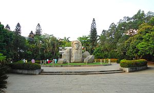
People's Park (Chinese: 人民公园; pinyin: Rénmín Gōngyuán) is a public park in Haikou, capital of Hainan Province, China. It is located in the centre of the city. It is bordered by Haixiu Road on the south.

Haikou People's Hospital
Hospital in Haikou, China
Distance: Approx. 1980 meters
Latitude and longitude: 20.062643,110.335629
The Haikou People's Hospital (Chinese: 海口市人民医院) is located on Renmin Avenue, Haidian Island, Haikou City, Hainan Province, China. The hospital was founded in 1901, and has a staff of 2,254 people. There are available 1,700 beds, with a further 1,200 planned.

Bo'ai Road area
Neighbourhood in Haikou, China
Distance: Approx. 302 meters
Latitude and longitude: 20.044337,110.339264
The Bo'ai Road area (Chinese: 博爱路小区; pinyin: Bó'ài Lù xiǎoqū) is a historical neighbourhood in Haikou City, Hainan, China. It is located on the south side of the Haidian River, at the northern part of mainland Haikou. The main hub of the neighbourhood is the north-south Bo'ai Road itself, a commercial road with shops selling such items as fabrics, wholesale toys, and pets, in particular freshwater fish.

Haikou Clock Tower
Monument in Bo'ai Road area, Haikou, Hainan, China
Distance: Approx. 140 meters
Latitude and longitude: 20.04454474,110.34161773
The Haikou Clock Tower (Chinese: 海口钟楼; pinyin: Hǎikǒu Zhōnglóu) is a clock tower located on the south side of the Haidian River, at the north end of the Bo'ai Road area, just west of the Renmin Bridge, in Haikou, Hainan, China. It was originally built around 1928–1929, an initiative by then-trade union leader 周成梅. During the Cultural Revolution it was partially destroyed.

Binhai Park
Park in Haikou, China
Distance: Approx. 1967 meters
Latitude and longitude: 20.04017,110.32387
Binhai Park (Chinese: 滨海公园) is an urban park located on the north side of Binhai Road, Haikou City, Hainan Province, China. It was once called Hainan (Haikou) Youth Technology Park.

Century Park (Haikou)
Public park in Haikou, China
Distance: Approx. 2401 meters
Latitude and longitude: 20.04461,110.31878
Century Park (Chinese: 世纪公园) is an 8.40-hectare, public park located downtown Haikou, in the Longhua district of the city, Hainan Province, China. It is located northwest of Binhai Park and east of Evergreen Park. The Haikou Century Bridge travels over part of it.

East Lake Triangle Pool
Urban lake in Hainan, China
Distance: Approx. 936 meters
Latitude and longitude: 20.0375,110.34027778
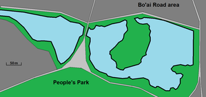
East Lake Triangle Pool (Chinese: 东湖三角池), commonly known as East Lake, is a set of two small lakes in the East Lake area of Haikou, Hainan, China. It is located at the south-west corner of the Bo'ai Road area and at the north side of People's Park.
Baisha Subdistrict, Haikou
Subdistrict in Hainan, People's Republic of China
Distance: Approx. 1804 meters
Latitude and longitude: 20.05166667,110.35777778
Baisha Subdistrict (Chinese: 白沙街道; pinyin: Báishā Jiēdào) is a subdistrict in Meilan District, Haikou, Hainan, China. As of 2018, it has 4 residential communities under its administration.
Weather in this IP's area
scattered clouds
19 Celsius
19 Celsius
19 Celsius
19 Celsius
1019 hPa
77 %
1019 hPa
1017 hPa
10000 meters
6 m/s
60 degree
40 %