Country:
 Australia
Region:
City:
Latitude and Longitude:
Time Zone:
Postal Code:
IP information under different IP Channel
ip-api
Country
Region
City
ASN
Time Zone
ISP
Blacklist
Proxy
Latitude
Longitude
Postal
Route
IPinfo
Country
Region
City
ASN
Time Zone
ISP
Blacklist
Proxy
Latitude
Longitude
Postal
Route
MaxMind
Country
Region
City
ASN
Time Zone
ISP
Blacklist
Proxy
Latitude
Longitude
Postal
Route
Luminati
Country
AURegion
vic
City
mildura
ASN
Time Zone
Australia/Melbourne
ISP
Neighbourhood Cable
Latitude
Longitude
Postal
db-ip
Country
Region
City
ASN
Time Zone
ISP
Blacklist
Proxy
Latitude
Longitude
Postal
Route
ipdata
Country
Region
City
ASN
Time Zone
ISP
Blacklist
Proxy
Latitude
Longitude
Postal
Route
Popular places and events near this IP address
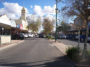
Mildura
Regional city in Victoria, Australia
Distance: Approx. 1131 meters
Latitude and longitude: -34.18888889,142.15833333
Mildura ( mill-DEW-rə) is a regional city in north-west Victoria, Australia. Located on the Victorian side of the Murray River, Mildura had a population of over 90,000 in 2024. When nearby Wentworth, Irymple, Nichols Point, Merbein and Red Cliffs are included, the combined urban area had a population over 150,000 in 2024, having grown marginally at an average annual rate of 1.3% year-on-year over the preceding five years.

Sunraysia
Region of Australia
Distance: Approx. 1814 meters
Latitude and longitude: -34.20615833,142.135725
Sunraysia is a region located in northwestern Victoria and southwestern New South Wales in Australia. The region is renowned for its sunshine, intensive horticulture including grapes and oranges. Its main centre is Mildura, Victoria.

Longest bar in Australia
Distance: Approx. 1360 meters
Latitude and longitude: -34.18759444,142.16036111
As with any such statistic, there are a number of claims for the title "the longest bar in Australia": Captains Flat, New South Wales: When the new Captains Flat Hotel was built in 1937, it was said to have the longest bar in Australia at the time; it was 32 metres (105 ft) long. Mildura, Victoria: The Mildura Working Man's Sports & Social Club built a T-shaped bar in 1938. It was believed to be the longest bar in Victoria.

Mildura railway station
Former railway line in Victoria, Australia
Distance: Approx. 1916 meters
Latitude and longitude: -34.182,142.1632
Mildura was the passenger terminus for the Mildura railway line in Victoria, Australia. Located in the city of Mildura it is located on the eastern side of the town centre, alongside the Murray River. Although there has not been a passenger rail service since 1993, the Victorian Labor Government has promised to return the service in 1999, though it has yet to return as of 2024.
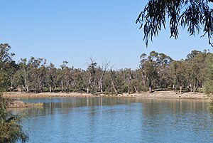
Murray Darling
Distance: Approx. 1131 meters
Latitude and longitude: -34.18888889,142.15833333
Murray Darling is a wine region and Australian Geographical Indication which spans the Murray River and its confluence with the Darling River in northwestern Victoria and southwestern New South Wales. It was registered as a protected name on 16 June 1997. Murray Darling is the second-largest wine region in Australia.

City of Mildura
Local government area in Victoria, Australia
Distance: Approx. 1089 meters
Latitude and longitude: -34.18333333,142.15
The City of Mildura was a local government area on the Murray River, in northwestern Victoria, Australia. The city covered an area of 29.86 square kilometres (11.5 sq mi), and existed from 1920 until 1995.
Sunraysia Institute of TAFE
Distance: Approx. 2247 meters
Latitude and longitude: -34.20341389,142.16776389
The Sunraysia Institute of TAFE, also known as SuniTAFE, is vocational education and training services provider in north-west Victoria, Australia.

3MPH
Radio station
Distance: Approx. 1212 meters
Latitude and longitude: -34.1867,142.1579
3MPH is a radio station based in Mildura, Victoria. It is part of the Vision Australia Radio network, a reading and information service for those persons unable to read or easily access information in print. The station is run and operated by volunteers.

Murray Basin
Cenozoic sedimentary basin in south eastern Australia
Distance: Approx. 1131 meters
Latitude and longitude: -34.18888889,142.15833333
The Murray Basin is a Cenozoic sedimentary basin in south eastern Australia. The basin is only shallow, but extends into New South Wales, Victoria and South Australia. It takes its name from the Murray River which traverses the Basin from east to west.
Barkindji Biosphere Reserve
Protected area in Australia
Distance: Approx. 3427 meters
Latitude and longitude: -34.16666667,142.16666667
Barkindji Biosphere Reserve is a biosphere reserve located in the Australian states of New South Wales and Victoria on land adjacent to the Murray River and within 80 kilometres (50 mi) of the city of Mildura. The biosphere reserve was described by UNESCO in 2016 as:Located in Southeast Australia, the Barkindji Biosphere Reserve lies within the largest river basin of Australia — the Murray-Darling Basin. Eleven land systems spread across dunes, sand plains, wetlands, floodplains and along the Murray River characterize the topography of the reserve.
Kureinji
Place in New South Wales, Australia
Distance: Approx. 3508 meters
Latitude and longitude: -34.18333333,142.18333333
The Kureinji, otherwise known as the Keramin, are an Aboriginal group whose traditional lands are located in southwest New South Wales, Australia, along the north side of the Murray River roughly between today's settlements of Euston and Wentworth.
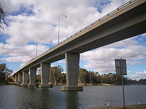
George Chaffey Bridge
Bridge
Distance: Approx. 2585 meters
Latitude and longitude: -34.18416667,142.17305556
The George Chaffey Bridge is a road bridge in Australia that carries the Sturt Highway across the Murray River from Buronga to Mildura.
Weather in this IP's area
scattered clouds
20 Celsius
19 Celsius
20 Celsius
20 Celsius
1011 hPa
44 %
1011 hPa
1005 hPa
10000 meters
8.69 m/s
10.57 m/s
269 degree
40 %
06:23:51
18:26:01