Country:
 Japan
JapanRegion:
City:
Latitude and Longitude:
Time Zone:
Postal Code:
IP information under different IP Channel
ip-api
Country
Region
City
ASN
Time Zone
ISP
Blacklist
Proxy
Latitude
Longitude
Postal
Route
IPinfo
Country
Region
City
ASN
Time Zone
ISP
Blacklist
Proxy
Latitude
Longitude
Postal
Route
MaxMind
Country
Region
City
ASN
Time Zone
ISP
Blacklist
Proxy
Latitude
Longitude
Postal
Route
Luminati
Country
JPRegion
14
City
atsugi
ASN
Time Zone
Asia/Tokyo
ISP
TOKAI Communications Corporation
Latitude
Longitude
Postal
db-ip
Country
Region
City
ASN
Time Zone
ISP
Blacklist
Proxy
Latitude
Longitude
Postal
Route
ipdata
Country
Region
City
ASN
Time Zone
ISP
Blacklist
Proxy
Latitude
Longitude
Postal
Route
Popular places and events near this IP address

Ebina, Kanagawa
City in Kantō, Japan
Distance: Approx. 4115 meters
Latitude and longitude: 35.44638889,139.39083333
Ebina (海老名市, Ebina-shi) is a city located in Kanagawa Prefecture, Japan.As of 1 June 2021, the city had an estimated population of 136,312 and a population density of 5100 persons per km2. The total area of the city is 26.69 square kilometres (10.31 sq mi).

Ebina Station
Railway station in Ebina, Kanagawa Prefecture, Japan
Distance: Approx. 4103 meters
Latitude and longitude: 35.45277778,139.39083333
Ebina Station (海老名駅, Ebina-eki) is an interchange passenger railway station located in the city of Ebina, Kanagawa, Japan. It is jointly operated by the East Japan Railway Company (JR East), and the private railway operators Odakyu Electric Railway, and Sagami Railway (Sōtetsu).

Atsugi
City in Kanagawa Prefecture, Japan
Distance: Approx. 2672 meters
Latitude and longitude: 35.43333333,139.36666667
Atsugi (厚木市, Atsugi-shi) is a city located in Kanagawa Prefecture, Japan. As of 1 June 2021, the city had an estimated population of 223,960 and a population density of 2400 persons per km2. The total area of the city is 93.83 square kilometres (36.23 sq mi).

Hon-Atsugi Station
Railway station in Atsugi, Kanagawa Prefecture, Japan
Distance: Approx. 2073 meters
Latitude and longitude: 35.439338,139.364261
Hon-Atsugi Station (本厚木駅, Hon-Atsugi-eki) is a major passenger railway station located in the city of Atsugi, Kanagawa, Japan, operated by the private railway operator Odakyu Electric Railway.

Atsugi Station
Railway station in Ebina, Kanagawa Prefecture, Japan
Distance: Approx. 3066 meters
Latitude and longitude: 35.44333333,139.37844444
Atsugi Station (厚木駅, Atsugi-eki) is a joint-use passenger railway station located in the city of Ebina, Kanagawa, Japan. It is jointly operated by the private railway company Odakyu Electric Railway and by the East Japan Railway Company (JR East). Odakyu manages the station premises.

Aikō-Ishida Station
Railway station in Atsugi, Kanagawa Prefecture, Japan
Distance: Approx. 3605 meters
Latitude and longitude: 35.417844,139.344083
Aikō-Ishida Station (愛甲石田駅, Aikō-Ishida-eki) is a passenger railway station located in the city of Atsugi, Kanagawa Prefecture, Japan. The station operated by the private railway operator Odakyu Electric Railway. Part of the station physically extends into neighboring Isehara city.
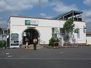
Shake Station
Railway station in Ebina, Kanagawa Prefecture, Japan
Distance: Approx. 4390 meters
Latitude and longitude: 35.42027778,139.37722222
Shake Station (社家駅, Shake-eki) is a passenger railway station located in the city of Ebina, Kanagawa Prefecture, Japan, operated by the East Japan Railway Company (JR East).

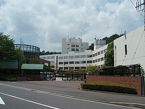
Tokyo University of Agriculture Botanical Garden
Distance: Approx. 1987 meters
Latitude and longitude: 35.432394,139.344155
The Tokyo University of Agriculture Botanical Garden (東京農業大学植物園, Tōkyō Nōgyō Daigaku Shokubutsuen) is a botanical garden operated by the Tokyo University of Agriculture, and located at 1737 Funako, Atsugi, Kanagawa, Japan. The garden was established in 1967, and now cultivates about 1,500 species of useful plants, including collections of Cactaceae and other succulents (such as Agave, Euphorbia, Kalanchoe, Stapelia, Sansevieria), Iris, Lilium, Paeonia, Rosa, Syringa, as well as flora of Asia and the Far East, Kazakhstan, Europe, the Americas, and medicinal plants and conifers such as Podocarpus. In addition, 310 species of wild plants grow in the garden.

Shoin University
Distance: Approx. 2775 meters
Latitude and longitude: 35.44305556,139.31638889
Shoin University (松蔭大学, Shōin daigaku) is a private university in Atsugi, Kanagawa Prefecture, Japan. Founded as a women's school in 1941, Shoin became coeducational in 2004. It is a member of the Western Metropolitan Area University Association.

Kanagawa Institute of Technology
Distance: Approx. 4014 meters
Latitude and longitude: 35.48611111,139.34166667
Kanagawa Institute of Technology (神奈川工科大学, Kanagawa kōka daigaku) (KAIT) is a private university in Atsugi, Kanagawa Prefecture, Japan. The predecessor of the school, a vocational school, was founded in 1963. It was chartered as a university in 1975.
Shohoku College
Japanese junior colleges
Distance: Approx. 1696 meters
Latitude and longitude: 35.435,139.34694444
Shōhoku College (湘北短期大学, Shōhoku tanki daigaku) is a private junior college in Atsugi, Kanagawa Prefecture, Japan. It was established in 1974 by Sony Corporation next to its Atsugi Technical Center. Initially, the school offered course work in electronic engineering and in housekeeping.

Ebina Junction
Road junction in Ebina, Kanagawa prefecture, Japan
Distance: Approx. 4239 meters
Latitude and longitude: 35.4225,139.37777778
Ebina Junction (海老名ジャンクション, Ebina Jankushon) is a junction that connects the Tōmei Expressway and the Ken-Ō Expressway in the town of Ebina, Kanagawa Prefecture, Japan. Initially, it was tentatively called Ebina Kita Junction (海老名北JCT), but the official name was announced on May 18, 2009. It is located near Shake Station on the Sagami Line.
Weather in this IP's area
scattered clouds
25 Celsius
25 Celsius
25 Celsius
26 Celsius
1017 hPa
71 %
1017 hPa
1010 hPa
10000 meters
0.45 m/s
1.34 m/s
223 degree
25 %
05:26:47
17:47:43