Country:
 Japan
JapanRegion:
City:
Latitude and Longitude:
Time Zone:
Postal Code:
IP information under different IP Channel
ip-api
Country
Region
City
ASN
Time Zone
ISP
Blacklist
Proxy
Latitude
Longitude
Postal
Route
IPinfo
Country
Region
City
ASN
Time Zone
ISP
Blacklist
Proxy
Latitude
Longitude
Postal
Route
MaxMind
Country
Region
City
ASN
Time Zone
ISP
Blacklist
Proxy
Latitude
Longitude
Postal
Route
Luminati
Country
JPRegion
42
City
nagasaki
ASN
Time Zone
Asia/Tokyo
ISP
Nagasaki Cable Media Inc.
Latitude
Longitude
Postal
db-ip
Country
Region
City
ASN
Time Zone
ISP
Blacklist
Proxy
Latitude
Longitude
Postal
Route
ipdata
Country
Region
City
ASN
Time Zone
ISP
Blacklist
Proxy
Latitude
Longitude
Postal
Route
Popular places and events near this IP address

Nagasaki
Core city in Kyushu, Japan
Distance: Approx. 838 meters
Latitude and longitude: 32.74472222,129.87361111
Nagasaki (Japanese: 長崎, Hepburn: Nagasaki) (IPA: [naɡaꜜsaki] ; lit. "Long Cape"), officially known as Nagasaki City (長崎市, Nagasaki-shi), is the capital and the largest city of the Nagasaki Prefecture on the island of Kyushu in Japan. Founded by the Portuguese, the port of Nagasaki became the sole port used for trade with the Portuguese and Dutch during the 16th through 19th centuries.

Nagasaki Naval Training Center
Distance: Approx. 834 meters
Latitude and longitude: 32.74503333,129.87348056
The Nagasaki Naval Training Center (長崎海軍伝習所, Nagasaki Kaigun Denshū-jo) was a naval training institute, between 1855 when it was established by the government of the Tokugawa shogunate, until 1859, when it was transferred to Tsukiji in Edo. During the Bakumatsu period, the Japanese government faced increasing incursions by ships from the Western world, intent on ending the country's two centuries of isolationist foreign policy. These efforts cumulated in the landing of United States commodore Matthew Perry in 1854, resulting in the Treaty of Kanagawa and the opening of Japan to foreign trade.

Kofukuji (Nagasaki)
Distance: Approx. 215 meters
Latitude and longitude: 32.74786111,129.88388889
Kōfuku-ji or Tōmeizan Kōfuku-ji (Japanese: 東明山興福寺, Tōmeizan Kōfuku-ji) is a Buddhist temple of the Ōbaku school of Zen established in 1624 in Nagasaki, Japan. It is an important cultural asset designated by the government. Its Mazu Hall (Masu-do) or Bodhisattva Hall (Bosa-do) is one of the few temples located in Japan of the Chinese sea goddess known as Mazu, the deified form of the medieval Fujianese shamaness Lin Moniang (Chinese: 林默孃).

Sōfuku-ji (Nagasaki)
Buddhist temple in Nagasaki, Japan
Distance: Approx. 681 meters
Latitude and longitude: 32.74222222,129.88361111
Sōfuku-ji (崇福寺) is an Ōbaku Zen temple that was built by the Chinese monk Chaonian (Chozen) in 1629 as the family temple of the Chinese from Fuzhou, Fujian Province who settled in Nagasaki.
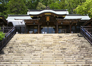
Suwa Shrine (Nagasaki)
Shinto shrine in Nagasaki, Japan
Distance: Approx. 706 meters
Latitude and longitude: 32.75444444,129.88166667
Suwa Shrine (諏訪神社, suwa jinja) is the major Shinto shrine of Nagasaki, Japan, and one of the major locations of the Nagasaki Kunchi, originally celebrated on the ninth day of the ninth lunar month and now celebrated on the fixed dates of October 7 to October 9. It is located in the northern part of the city, on the slopes of Mount Tamazono, and features a 277-step stone staircase leading up the mountain to the various buildings that comprise the shrine. Suwa Shrine was established as a way of stopping and reverting the conversion to Christianity that was taking place in Nagasaki.

Nagasaki Museum of History and Culture
Mosque in Nagasaki, Japan
Distance: Approx. 556 meters
Latitude and longitude: 32.7528,129.8796
The Nagasaki Museum of History and Culture (長崎歴史文化博物館, Nagasaki Rekishi Bunka Hakubutsukan) in Nagasaki, Japan is one of the few museums in Japan devoted to the theme of "overseas exchange". The museum holds 48,000 items in its collection, including historical documents and arts and crafts, that tell the story of Nagasaki as the sole window opened to foreign countries during the period of national isolation. The museum also contains a reconstruction of part of the Nagasaki Magistrate's Office called bugyōsho, a local agency of the central government in the Edo period.

Megane Bridge
Japanese stone arch bridge in Nagasaki
Distance: Approx. 174 meters
Latitude and longitude: 32.747207,129.880087
Meganebashi (眼鏡橋) or Spectacles Bridge, over the Nakashima River (中島川) was built in Nagasaki in 1634 by the Chinese monk Mokusunyoujo who was in the second generation of Chinese monks living at Kofukuji Temple. It is said to be the oldest stone arch bridge in Japan along with Edo's Nihonbashi bridge and Iwakuni's Kintaikyou bridge and has been designated as an Important Cultural Property. Megane Bridge is also part of the first group of bridges built over Nakashima river.

Nagasaki Kunchi
Distance: Approx. 672 meters
Latitude and longitude: 32.754125,129.88211111
Kunchi (くんち), also Nagasaki Kunchi (長崎くんち) or Nagasaki Okunchi (長崎おくんち), is the most famous festival in Nagasaki, Japan. It began as a celebration of autumn harvests in the late 16th century and became a shrine festival when Suwa Shrine was founded in 1614. The name kunchi is derived from the word kunichi (九日, the ninth day of the ninth lunar month of the year).
VOC chief traders in Japan
Heads of the Dutch trading post in Japan
Distance: Approx. 952 meters
Latitude and longitude: 32.743525,129.873022
VOC chief traders in Japan were the chief traders (opperhoofden) of the Dutch East India Company (Vereenigde Oostindische Compagnie or VOC in old-spelling Dutch, literally "United East Indian Company") in Japan during the period of the Tokugawa shogunate, also known as the Edo period. Opperhoofd is a Dutch word (plural opperhoofden) which literally means 'supreme head[man]'. In its historical usage, the word is a gubernatorial title, comparable to the English chief factor, for the chief executive officer of a Dutch factory in the sense of trading post, as led by a factor, i.e.

Nagasaki Shinchi Chinatown
Ethnic enclave in Nagasaki, Japan
Distance: Approx. 873 meters
Latitude and longitude: 32.74194444,129.87583333
Nagasaki Shinchi Chinatown (Japanese: ながさき しんち ちゅうかがい, 長崎新地中華街, Simplified Chinese: 长崎新地中华街) is an area located in Nagasaki, Nagasaki, Japan. Today this area is a shopping strip covering many blocks. Most of the Chinese members of Nagasaki Chinatown are of Fuzhounese descent.

Shōfuku-ji (Nagasaki)
Buddhist temple in Nagasaki Prefecture, Japan
Distance: Approx. 700 meters
Latitude and longitude: 32.753,129.87693
Shōfuku-ji (聖福寺) is an Ōbaku Zen temple in Nagasaki, Nagasaki, Japan. Its honorary sangō prefix is Manjusan (万寿山). Shōfuku-ji was the fourth of a series of temples built in the 17th century by the Chinese community of Nagasaki.

Fukusai-ji
Buddhist temple in Nagasaki Prefecture, Japan
Distance: Approx. 889 meters
Latitude and longitude: 32.75353,129.87465
Fukusai-ji (福済寺) is an Ōbaku Zen temple in Nagasaki, Nagasaki, Japan. Its honorary sangō prefix is Bunshizan (分紫山).
Weather in this IP's area
few clouds
30 Celsius
34 Celsius
30 Celsius
30 Celsius
1011 hPa
66 %
1011 hPa
1009 hPa
10000 meters
6.17 m/s
360 degree
20 %
05:59:45
18:36:59