Country:
 Japan
JapanRegion:
City:
Latitude and Longitude:
Time Zone:
Postal Code:
IP information under different IP Channel
ip-api
Country
Region
City
ASN
Time Zone
ISP
Blacklist
Proxy
Latitude
Longitude
Postal
Route
IPinfo
Country
Region
City
ASN
Time Zone
ISP
Blacklist
Proxy
Latitude
Longitude
Postal
Route
MaxMind
Country
Region
City
ASN
Time Zone
ISP
Blacklist
Proxy
Latitude
Longitude
Postal
Route
Luminati
Country
JPRegion
24
City
sakaemachi
ASN
Time Zone
Asia/Tokyo
ISP
Matsusaka Cable-TV Station Inc.
Latitude
Longitude
Postal
db-ip
Country
Region
City
ASN
Time Zone
ISP
Blacklist
Proxy
Latitude
Longitude
Postal
Route
ipdata
Country
Region
City
ASN
Time Zone
ISP
Blacklist
Proxy
Latitude
Longitude
Postal
Route
Popular places and events near this IP address

Mie Prefecture
Prefecture of Japan
Distance: Approx. 1699 meters
Latitude and longitude: 34.7,136.5
Mie Prefecture (Japanese: 三重県, Hepburn: Mie-ken) is a prefecture of Japan located in the Kansai region of Honshu. Mie Prefecture has a population of 1,781,948 (as of 1 June 2019) and has a geographic area of 5,774 square kilometers (2,229 sq mi). Mie Prefecture is bordered by Gifu Prefecture to the north, Shiga Prefecture and Kyoto Prefecture to the northwest, Nara Prefecture to the west, Wakayama Prefecture to the southwest, and Aichi Prefecture to the east.

Tsu, Mie
City in Kansai, Japan
Distance: Approx. 2190 meters
Latitude and longitude: 34.73305556,136.51333333
Tsu (津市, Tsu-shi) is the capital city of Mie Prefecture, Japan. As of 31 July 2021, the city had an estimated population of 274,879 in 127,273 households and a population density of 390 persons per km2. The total area of the city is 711.11 square kilometres (274.56 sq mi).

Tsu Station
Railway station in Tsu, Mie Prefecture, Japan
Distance: Approx. 2240 meters
Latitude and longitude: 34.73398611,136.51023333
Tsu Station (津駅, Tsu-eki) is a junction passenger railway station located in the city of Tsu, Mie Prefecture, operated by Central Japan Railway Company (JR Central), the private railway operator Kintetsu and the third sector Ise Railway. The name of the station is considered the shortest in Japan because it is the only station name that is written with one kana, even though other stations have shorter names when written in Latin letters, such as Oe Station.

Edobashi Station
Railway station in Tsu, Mie Prefecture, Japan
Distance: Approx. 3352 meters
Latitude and longitude: 34.74361111,136.51405556
"Edobashi Station" may also refer to Tokyo subway Nihombashi Station on Toei Asakusa Line, named "Edobashi" 1963 to 1989. Edobashi Station (江戸橋駅, Edobashi-eki) is a passenger railway station in located in the city of Tsu, Mie Prefecture, Japan, operated by the private railway operator Kintetsu Railway.

Tsu-shimmachi Station
Railway station in Tsu, Mie Prefecture, Japan
Distance: Approx. 689 meters
Latitude and longitude: 34.7158,136.5002
Tsu-Shimmachi Station (津新町駅, Tsu-shimmachi-eki) is a passenger railway station in located in the city of Tsu, Mie Prefecture, Japan, operated by the private railway operator Kintetsu Railway.

Minamigaoka Station
Railway station in Tsu, Mie Prefecture, Japan
Distance: Approx. 2600 meters
Latitude and longitude: 34.6924,136.4966
Minamigaoka Station (南が丘駅, Minamigaoka-eki) is a passenger railway station in located in the city of Tsu, Mie Prefecture, Japan, operated by the private railway operator Kintetsu Railway.
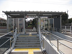
Akogi Station
Railway station in Tsu, Mie Prefecture, Japan
Distance: Approx. 1189 meters
Latitude and longitude: 34.70361111,136.50436111
Akogi Station (阿漕駅, Akogi-eki) is a passenger railway station in located in the city of Tsu, Mie Prefecture, Japan, operated by Central Japan Railway Company (JR Tōkai).
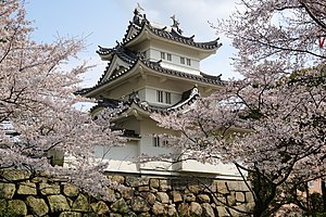
Tsu Castle
Distance: Approx. 420 meters
Latitude and longitude: 34.71776667,136.50765833
Tsu Castle (津城, Tsu-jō) was a Japanese castle located in the city of Tsu, Mie Prefecture, Japan. During the Edo period, Tsu Castle was home to the Sudo clan, daimyō of Tsu Domain, who dominated the provinces of Ise and Iga under the Tokugawa shogunate. The castle was also known as "Anotsu-jō" (安濃津城) after the ancient name for Tsu.
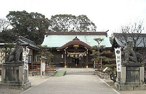
Yūki Shrine
Distance: Approx. 1950 meters
Latitude and longitude: 34.6977,136.5152
Yūki Shrine (結城神社, Yūki jinja) is a Shinto shrine located in the city of Tsu, Mie Prefecture, Japan. Its main festival is held annually on May 1, 2 and 3. It is one of the Fifteen Shrines of the Kenmu Restoration.

Mie Prefectural Art Museum
Building in Mie Prefecture, Japan
Distance: Approx. 2374 meters
Latitude and longitude: 34.734868,136.502069
Mie Prefectural Art Museum (三重県立美術館, Mie kenritsu bijutsukan) opened in Tsu, Mie Prefecture, Japan, in 1982. The collection has a particular emphasis on yōga.

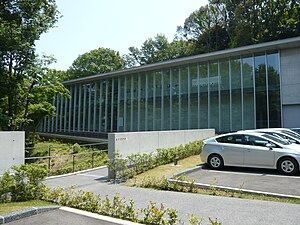
Mie Prefectural Museum
Building in Mie Prefecture, Japan
Distance: Approx. 3180 meters
Latitude and longitude: 34.742194,136.50178
Mie Prefectural Museum (三重県総合博物館, Mie-ken sōgō hakubutsukan) opened on a new site in Tsu, Mie Prefecture, Japan, in 2014. Also known as MieMu, it replaced the former Mie Prefectural Museum (三重県立博物館, Mie kenritsu hakubutsukan) which opened in 1953 and closed in 2014.
Sekisui Museum
Museum in Tsu, Mie Prefecture, Japan
Distance: Approx. 1805 meters
Latitude and longitude: 34.697935,136.504726
Sekisui Museum (石水博物館, Sekisui Hakubutsukan) is a registered museum in Tsu, Mie Prefecture, Japan. First established as Sekisui Kaikan (石水会館) in 1930, the museum was registered in accordance with the Museum Act in 1975, reorganized as a "public interest incorporated foundation" under its present name in 2010, and in the following year relocated from Marunouchi to Tarumi (both in Tsu), reopening in new premises nestled in a wooded area of Mount Chitose in May 2011. The collection includes tea utensils, paintings, books, historical materials relating to the merchants of Ise Province, and items relating to potter and founder Kawakita Handeishi (川喜田半泥子) (1878–1963).
Weather in this IP's area
overcast clouds
25 Celsius
26 Celsius
25 Celsius
25 Celsius
1020 hPa
82 %
1020 hPa
1020 hPa
10000 meters
1.77 m/s
1.83 m/s
279 degree
94 %
05:51:26
17:33:08