Country:
 Japan
JapanRegion:
City:
Latitude and Longitude:
Time Zone:
Postal Code:
IP information under different IP Channel
ip-api
Country
Region
City
ASN
Time Zone
ISP
Blacklist
Proxy
Latitude
Longitude
Postal
Route
IPinfo
Country
Region
City
ASN
Time Zone
ISP
Blacklist
Proxy
Latitude
Longitude
Postal
Route
MaxMind
Country
Region
City
ASN
Time Zone
ISP
Blacklist
Proxy
Latitude
Longitude
Postal
Route
Luminati
Country
JPRegion
36
City
kawauchicho
ASN
Time Zone
Asia/Tokyo
ISP
STNet, Incorporated
Latitude
Longitude
Postal
db-ip
Country
Region
City
ASN
Time Zone
ISP
Blacklist
Proxy
Latitude
Longitude
Postal
Route
ipdata
Country
Region
City
ASN
Time Zone
ISP
Blacklist
Proxy
Latitude
Longitude
Postal
Route
Popular places and events near this IP address
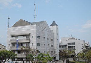
Matsushige, Tokushima
Town in Shikoku, Japan
Distance: Approx. 2649 meters
Latitude and longitude: 34.13388889,134.58027778
Matsushige (松茂町, Matsushige-chō) is a town located in Itano District, Tokushima Prefecture, Japan. As of 1 April 2022, the town had an estimated population of 14,770 in 6794 households and a population density of 1000 persons per km². The total area of the town is 14.24 square kilometres (5.50 sq mi).

Kitajima, Tokushima
Town in Shikoku, Japan
Distance: Approx. 3231 meters
Latitude and longitude: 34.13333333,134.55
Kitajima (北島町, Kitajima-chō) is a town located in Itano District, Tokushima Prefecture, Japan. As of 1 December 2023, the town had an estimated population of 23,680 in 10340 households and a population density of 2700 persons per km2. The total area of the town is 8.74 square kilometres (3.37 sq mi).
Yoshino River
River in Shikoku, Japan
Distance: Approx. 4462 meters
Latitude and longitude: 34.078499,134.600722
The Yoshino River (吉野川 Yoshino-gawa) is a river on the island of Shikoku, Japan. It is 194 km (121 mi) long and has a watershed of 3,750 km2 (1,450 sq mi). It is the second longest river in Shikoku (slightly shorter than the Shimanto), and is the only river whose watershed spreads over the four prefectures of the island.

Tokushima Airport
Airport
Distance: Approx. 4131 meters
Latitude and longitude: 34.13222222,134.60916667
Tokushima Awaodori Airport (徳島阿波おどり空港, Tokushima Awa-odori kūkō) (IATA: TKS, ICAO: RJOS) is a joint civil-military public airport in Matsushige, Tokushima, Japan, near the city of Tokushima. In addition to scheduled passenger operations, the airport is the base of the Japan Maritime Self-Defense Force Tokushima Air Training Group of 202nd Naval Air Training Squadron equipped with Beechcraft TC-90. There are also UH-60J Search and Rescue aircraft of one flight which detached from JMSDF 72 Squadron.
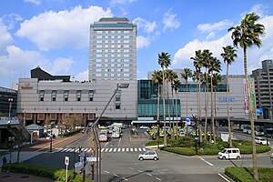
Tokushima Station
Railway station in Tokushima, Japan
Distance: Approx. 4518 meters
Latitude and longitude: 34.07444444,134.55111111
Tokushima Station (徳島駅, Tokushima-eki) is a junction passenger railway station located in the city of Tokushima in Tokushima Prefecture, Japan, operated by the Shikoku Railway Company (JR Shikoku).
Tokushima Domain
Distance: Approx. 4287 meters
Latitude and longitude: 34.07519167,134.555275
Tokushima Domain (徳島藩, Tokushima-han) was a feudal domain under the Tokugawa shogunate of Edo period Japan, controlling all of Awa Province and Awaji Province in what is now Tokushima Prefecture and Awaji Island of modern-day Hyōgo Prefecture. It was centered around Tokushima Castle, and was ruled throughout its history by the tozama daimyō Hachisuka clan.

Joto High School
School in Tokushima, Tokushima, Japan
Distance: Approx. 4463 meters
Latitude and longitude: 34.0725,134.55888889
Tokushima Prefectural Joto High School (徳島県立城東高等学校, Tokushima Kenritsu Jōtō Kōtō Gakkō) is a secondary school in Tokushima, Tokushima, Japan, founded in 1902. It is one of the top high schools in Tokushima Prefecture. Approximately 1,100 students attend the school.

Sako Station
Railway station in Tokushima, Japan
Distance: Approx. 4652 meters
Latitude and longitude: 34.0802,134.5383
Sako Station (佐古駅, Sako-eki) is a junction passenger railway station located in the city of Tokushima, Tokushima Prefecture, Japan. It is operated by JR Shikoku and has two station numbers: "B01" for the Tokushima Line and "T01" for the Kōtoku Line.

Yoshinari Station
Railway station in Tokushima, Japan
Distance: Approx. 3940 meters
Latitude and longitude: 34.1188,134.5307
Yoshinari Station (吉成駅, Yoshinari-eki) is a passenger railway station located in the city of Tokushima, Tokushima Prefecture, Japan. It is operated by JR Shikoku and has the station number "T02".

Shōzui Station
Distance: Approx. 4508 meters
Latitude and longitude: 34.128,134.528
Shōzui Station (勝瑞駅, Shōzui-eki) is a passenger railway station located in the town of Aizumi, Itano District, Tokushima Prefecture, Japan. It is operated by JR Shikoku and has the station number "T03".

Tokushima Castle Museum
Building in Tokushima Prefecture, Japan
Distance: Approx. 4436 meters
Latitude and longitude: 34.073617,134.55573
Tokushima Castle Museum (徳島市立徳島城博物館, Tokushima shiritsu Tokushima-jō hakubutsukan) opened in Tokushima, Japan, in 1992. The museum is located in a garden with the ruins of Tokushima Castle, and features exhibits about the history of the castle.
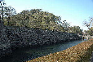
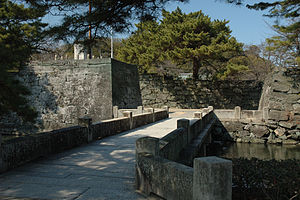
Tokushima Castle
Distance: Approx. 4287 meters
Latitude and longitude: 34.07519167,134.555275
Tokushima Castle (徳島城, Tokushima-jō) was an Edo period Japanese castle located in the city of Tokushima, Tokushima Prefecture, Japan. Its ruins have been protected as a National Historic Site since 1957. Its Omotegoten Gardens are designated a national Place of Scenic Beauty.
Weather in this IP's area
broken clouds
27 Celsius
29 Celsius
27 Celsius
31 Celsius
1016 hPa
74 %
1016 hPa
1016 hPa
10000 meters
2.06 m/s
240 degree
75 %
05:48:19
18:02:09