Country:
 Japan
JapanRegion:
City:
Latitude and Longitude:
Time Zone:
Postal Code:
IP information under different IP Channel
ip-api
Country
Region
City
ASN
Time Zone
ISP
Blacklist
Proxy
Latitude
Longitude
Postal
Route
IPinfo
Country
Region
City
ASN
Time Zone
ISP
Blacklist
Proxy
Latitude
Longitude
Postal
Route
MaxMind
Country
Region
City
ASN
Time Zone
ISP
Blacklist
Proxy
Latitude
Longitude
Postal
Route
Luminati
Country
JPRegion
12
City
narashinoshi
ASN
Time Zone
Asia/Tokyo
ISP
TOKAI Communications Corporation
Latitude
Longitude
Postal
db-ip
Country
Region
City
ASN
Time Zone
ISP
Blacklist
Proxy
Latitude
Longitude
Postal
Route
ipdata
Country
Region
City
ASN
Time Zone
ISP
Blacklist
Proxy
Latitude
Longitude
Postal
Route
Popular places and events near this IP address
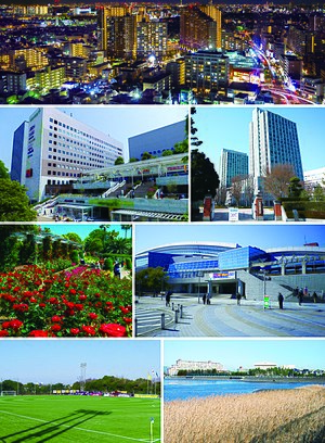
Narashino
City in Kantō, Japan
Distance: Approx. 537 meters
Latitude and longitude: 35.68038889,140.0265
Narashino (習志野市, Narashino-shi) is a city located in Chiba Prefecture, Japan. As of 30 November 2020, the city had an estimated population of 175,292 in 81,985 households and a population density of 8400 persons per km2.
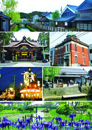
Katori, Chiba
City in Kantō, Japan
Distance: Approx. 273 meters
Latitude and longitude: 35.68333333,140.03333333
Katori (香取市, Katori-shi) is a city located in Chiba Prefecture, Japan. As of 1 November 2020, the city had an estimated population of 74,469 in 31,113 households and a population density of 280 persons per km2. The total area of the city is 262.31 square kilometres (101.28 sq mi).

Tsudanuma
Place in Chiba Prefecture, Japan
Distance: Approx. 870 meters
Latitude and longitude: 35.6823,140.0229
Tsudanuma (津田沼) is a district of Narashino City, Chiba Prefecture, Japan, consisting of 1-chōme to 7-chōme. The name “Tsudanuma” is also used to refer to the area around Tsudanuma Station ranging over Narashino and Funabashi cities.

Keisei Tsudanuma Station
Railway station in Narashino, Chiba Prefecture, Japan
Distance: Approx. 775 meters
Latitude and longitude: 35.683645,140.024459
Keisei Tsudanuma Station (京成津田沼駅, Keisei Tsudanuma-eki) is a junction passenger railway station in the city of Narashino, Chiba Prefecture, Japan, operated by the private railway operator Keisei Electric Railway.

Keisei Ōkubo Station
Railway station in Narashino, Chiba Prefecture, Japan
Distance: Approx. 1593 meters
Latitude and longitude: 35.6862,140.0488
Keisei-Ōkubo Station (京成大久保駅, Keisei-Ōkubo-eki) is a passenger railway station in the city of Narashino, Chiba Prefecture, Japan, operated by the private railway operator Keisei Electric Railway.

Ōnomatsu stable
Distance: Approx. 1189 meters
Latitude and longitude: 35.6705,140.0348
Ōnomatsu stable (阿武松部屋, Ōnomatsu-beya) is a stable of sumo wrestlers, one of the Nishonoseki ichimon or group of stables. It was founded in its modern form on 1 October 1994 by Masurao Hiroo, who branched off from the now defunct Oshiogawa stable. As of January 2023, the stable had 13 wrestlers.

Chiba Institute of Technology
University in Chiba Prefecture, Japan
Distance: Approx. 1385 meters
Latitude and longitude: 35.68916667,140.02083333
Chiba Institute of Technology (千葉工業大学, Chiba kōgyō daigaku) is a private university in Narashino, Chiba, Japan. Abbreviated as Chiba kōdai (千葉工大, Chiba kōdai), Chiba kō (千葉工, Chiba kō), kōdai (工大, kōdai), sen kōdai (千工大, sen kōdai). The school was founded in 1942 in Machida, Tokyo.

Tsudanuma Station
Railway station in Narashino, Chiba Prefecture, Japan
Distance: Approx. 1567 meters
Latitude and longitude: 35.691221,140.020478
Tsudanuma Station (津田沼駅, Tsudanuma-eki) is a junction passenger railway station located in the city of Narashino, Chiba, Japan, operated by the East Japan Railway Company (JR East).

Makuharihongō Station
Railway station in Chiba, Japan
Distance: Approx. 1286 meters
Latitude and longitude: 35.6728,140.0424
Makuharihongō Station (幕張本郷駅, Makuharihongō-eki) is a railway station in Makuharihongo, Hanamigawa Ward, Chiba City, Chiba Prefecture, Japan, operated by East Japan Railway Company (JR East) and the private railway operator Keisei Electric Railway. The Keisei section of the station is officially named Keisei Makuharihongō Station (京成幕張本郷駅, Keisei Makuharihongō-eki).

Shin-Tsudanuma Station
Railway station in Narashino, Chiba Prefecture, Japan
Distance: Approx. 1307 meters
Latitude and longitude: 35.6905,140.0239
Shin-Tsudanuma Station (新津田沼駅, Shin-Tsudanuma-eki) is a passenger railway station located in the city of Narashino, Chiba Prefecture Japan, operated by the private railway company, Shin-Keisei Electric Railway. The station is 400 meters from Tsudanuma Station on the JR East Sobu Main Line.
Makuharihongo
Place in Chiba Prefecture, Japan
Distance: Approx. 1281 meters
Latitude and longitude: 35.6724,140.0418
Makuharihongo (幕張本郷, Makuharihongō) is a district of Hanamigawa Ward, Chiba City, Chiba Prefecture, Japan, consisting of 1-chōme to 7-chōme.

Okubo, Narashino
Place in Chiba Prefecture, Japan
Distance: Approx. 1711 meters
Latitude and longitude: 35.6879,140.0493
Okubo (大久保, Ōkubo) is a district of Narashino City, Chiba Prefecture, Japan, consisting of 1-chōme to 4-chōme. The name “Okubo” is also used to refer to the area around Keisei Ōkubo Station.
Weather in this IP's area
broken clouds
25 Celsius
26 Celsius
25 Celsius
26 Celsius
1017 hPa
80 %
1017 hPa
1015 hPa
10000 meters
1.08 m/s
1.58 m/s
185 degree
81 %
05:23:58
17:45:02