Country:
 Netherlands
Region:
City:
Latitude and Longitude:
Time Zone:
Postal Code:
IP information under different IP Channel
ip-api
Country
Region
City
ASN
Time Zone
ISP
Blacklist
Proxy
Latitude
Longitude
Postal
Route
IPinfo
Country
Region
City
ASN
Time Zone
ISP
Blacklist
Proxy
Latitude
Longitude
Postal
Route
MaxMind
Country
Region
City
ASN
Time Zone
ISP
Blacklist
Proxy
Latitude
Longitude
Postal
Route
Luminati
Country
NLASN
Time Zone
Europe/Amsterdam
ISP
Luna.nl B.V.
Latitude
Longitude
Postal
db-ip
Country
Region
City
ASN
Time Zone
ISP
Blacklist
Proxy
Latitude
Longitude
Postal
Route
ipdata
Country
Region
City
ASN
Time Zone
ISP
Blacklist
Proxy
Latitude
Longitude
Postal
Route
Popular places and events near this IP address
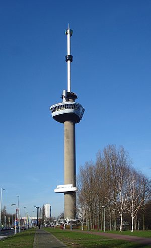
Euromast
Observation tower, Hotel in Rotterdam, Netherlands
Distance: Approx. 242 meters
Latitude and longitude: 51.906111,4.465833
Euromast is an observation tower in Rotterdam, Netherlands, designed by Hugh Maaskant constructed between 1958 and 1960. It was specially built for the 1960 Floriade, and is a listed monument since 2010. The tower is a concrete structure with an internal diameter of 9 m (30 ft) and a wall thickness of 30 cm (12 in).

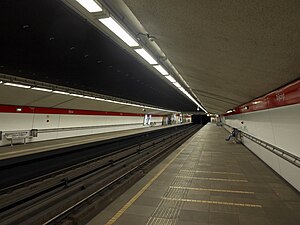
Coolhaven metro station
Metro station in Rotterdam, Netherlands
Distance: Approx. 429 meters
Latitude and longitude: 51.90972222,4.45805556
Coolhaven is an underground subway station in the Dutch city of Rotterdam. It is served by Rotterdam Metro lines A, B, and C. The station, with one island platform, opened on 10 May 1982 as the western terminus of the East-West Line (also formerly called Calandlijn). Coolhaven was the terminus until 1986, when the line was extended to Marconiplein.
Dijkzigt metro station
Metro station in Rotterdam, Netherlands
Distance: Approx. 604 meters
Latitude and longitude: 51.91222222,4.46611111
Dijkzigt is an underground subway station in the city of Rotterdam, and is served by Rotterdam Metro lines A, B, and C. The station is located next to the Erasmus MC (the biggest hospital in the Netherlands) and the Erasmus University. Dijkzigt station was opened on 10 May 1982 as a station of the East-West Line (or Caland line). The station is located underneath the Rochussenstraat and there is interchange with buslines 44 and 46.

Erasmus MC
Hospital in Rotterdam, Netherlands
Distance: Approx. 534 meters
Latitude and longitude: 51.91055556,4.46833333
Erasmus University Medical Center (Erasmus MC or EMC) based in Rotterdam, Netherlands, affiliated with Erasmus University and home to its faculty of medicine, is the largest and one of the most authoritative scientific university medical centers in Europe. The hospital is the largest of the eight university medical centers in the Netherlands, both in terms of turnover and number of beds. The Erasmus MC ranks #1 among the top European institution in clinical medicine and #20 in the world, according to the Times Higher Education rankings.
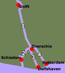
Schie
River in South Holland, Netherlands
Distance: Approx. 118 meters
Latitude and longitude: 51.90638889,4.46388889
Schie (Dutch pronunciation: [sxi]) the name for four waterways in the area of Overschie, South Holland, the Netherlands. There are the Delftse Schie, the Delfshavense Schie, the Rotterdamse Schie and the Schiedamse Schie. The existence of these four streams is the result of medieval rivalry among the cities of Delft, Rotterdam, and Schiedam for toll rights.

Schiecentrale
National monument in Netherlands
Distance: Approx. 507 meters
Latitude and longitude: 51.90305556,4.45972222
The Schiecentrale is a former power plant and national monument in Rotterdam, the Netherlands. After redevelopment the building is home to film studios, offices and apartments. The building is located in the hip quarter Lloydkwartier in Rotterdam North bank by the river Meuse.
Lloydkwartier
Neighborhood of Rotterdam in Rijnmond, South Holland, Netherlands
Distance: Approx. 671 meters
Latitude and longitude: 51.90166667,4.45888889
Lloydkwartier is a neighborhood of Rotterdam, Netherlands.
STC Group
Distance: Approx. 619 meters
Latitude and longitude: 51.90171944,4.46126944
The Shipping and Transport College Group (STC Group) is an international maritime transport and logistics education provider, which also offers consultancy and applied research in the field of shipping, ports, transport, logistics and port-related oil and chemical activities. The group has a number of schools and training centers worldwide and offers both master's/bachelor's degrees and vocational diplomas. The group's headquarters is located in Rotterdam, the Netherlands.

Baden Powelllaan 12, Rotterdam
Distance: Approx. 393 meters
Latitude and longitude: 51.90680556,4.46847222
Baden Powelllaan 12 is an old house (Heerenhuis) in Het Park, Rotterdam, built circa 1760. Found near the Euromast it was the main building of the De Heuvel estate. From 1875 this villa forms part of the Park.

FG (restaurant)
Restaurant in Rotterdam, Netherlands
Distance: Approx. 551 meters
Latitude and longitude: 51.90235,4.46115556
FG (formerly Ivy) is a restaurant in Rotterdam, Netherlands. It is a fine dining restaurant that was awarded one Michelin star for the period 2010–2013, and two stars since 2014. GaultMillau awarded the restaurant 17.5 out of 20 points.

Museum Rotterdam
History museum in Rotterdam, Netherlands
Distance: Approx. 414 meters
Latitude and longitude: 51.90893,4.45745
The Museum Rotterdam, until 2011 called the Historical Museum Rotterdam, is a museum about the history of Rotterdam located at the Coolhaven.
Erasmus MC Sophia
Hospital in Rotterdam, Netherlands
Distance: Approx. 534 meters
Latitude and longitude: 51.91055556,4.46833333
The Erasmus MC Sophia, earlier called Sophia Kinderziekenhuis, is the children's hospital of the larger Rotterdam Erasmus University Hospital and a former independent hospital in Rotterdam, the Netherlands. The Children's hospital, named after Queen Sophia, is the oldest children's hospital in the Netherlands. It was built in 1863 on the present-day Hoogstraat ("High Street"), on the site where the Beurstraverse ("Stock Exchange Traverse") currently stands.
Weather in this IP's area
overcast clouds
18 Celsius
18 Celsius
17 Celsius
19 Celsius
1014 hPa
82 %
1014 hPa
1013 hPa
10000 meters
0.51 m/s
100 %
08:12:14
18:41:55