Country:
 Netherlands
Region:
City:
Latitude and Longitude:
Time Zone:
Postal Code:
IP information under different IP Channel
ip-api
Country
Region
City
ASN
Time Zone
ISP
Blacklist
Proxy
Latitude
Longitude
Postal
Route
IPinfo
Country
Region
City
ASN
Time Zone
ISP
Blacklist
Proxy
Latitude
Longitude
Postal
Route
MaxMind
Country
Region
City
ASN
Time Zone
ISP
Blacklist
Proxy
Latitude
Longitude
Postal
Route
Luminati
Country
NLASN
Time Zone
Europe/Amsterdam
ISP
Luna.nl B.V.
Latitude
Longitude
Postal
db-ip
Country
Region
City
ASN
Time Zone
ISP
Blacklist
Proxy
Latitude
Longitude
Postal
Route
ipdata
Country
Region
City
ASN
Time Zone
ISP
Blacklist
Proxy
Latitude
Longitude
Postal
Route
Popular places and events near this IP address

KPN Tower
Distance: Approx. 239 meters
Latitude and longitude: 51.907,4.489
KPN Tower is a 96.5 metre tall office building in Rotterdam (a city in the Netherlands). It was designed by Italian architect Renzo Piano and construction began in 1998. The building was officially opened by its owner KPN on September 28, 2000.
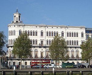
Wereldmuseum
Ethnographic museum in Rotterdam, Netherlands
Distance: Approx. 530 meters
Latitude and longitude: 51.9079,4.4804
The Wereldmuseum Rotterdam (formerly known as the Museum voor Land- en Volkenkunde) is an ethnographic museum, situated at Willemskade in Rotterdam, the Netherlands. The museum was founded in 1883 and shows more than 1800 ethnographic objects from various cultures in Asia, Oceania, Africa, the Americas and the Islamic heritage.

Erasmusbrug
Bridge in Rotterdam, The Netherlands
Distance: Approx. 431 meters
Latitude and longitude: 51.90916667,4.48666667
The Erasmusbrug (English: "Erasmus Bridge") is a combined cable-stayed and bascule bridge, construction began in 1986 and was completed in 1996. It crosses the Nieuwe Maas in the centre of Rotterdam, connecting the north and south parts of this city, second largest in the Netherlands. The bridge was named in 1992 after Desiderius Erasmus, a prominent Christian Renaissance humanist also known as Erasmus of Rotterdam.

Montevideo (Rotterdam)
43-storey, 139.5 m (458 ft) residential skyscraper in Rotterdam, The Netherlands
Distance: Approx. 209 meters
Latitude and longitude: 51.90361,4.48556
Montevideo is a 43-storey, 139.5 m (458 ft) residential skyscraper on the river Nieuwe Maas in Rotterdam, The Netherlands. The Montevideo logo on the roof is an 8 by 8 m (26 by 26 ft) letter "M" which brings the tower's total height to 152.3 m (500 ft). The logo is also designed to be a giant wind vane.
Eneco
Utility company in the Netherlands
Distance: Approx. 59 meters
Latitude and longitude: 51.90555556,4.48611111
Eneco, the trading name of Eneco Groep N.V., is a producer and supplier of natural gas, electricity and heat in the Netherlands, serving more than 2 million business and residential customers. The company's headquarters are located in Rotterdam. It also carries out energy trading and is involved in sustainable energy projects.

World Port Center
Commercial offices in Rotterdam, Netherlands
Distance: Approx. 149 meters
Latitude and longitude: 51.9049,4.4848
World Port Centre is a 33-storey, 123.1 m (404 ft) skyscraper in Rotterdam, Netherlands.

Wilhelminaplein metro station
Metro station in Rotterdam, Netherlands
Distance: Approx. 527 meters
Latitude and longitude: 51.90722222,4.49388889
Wilhelminaplein is an underground subway station in Rotterdam, Netherlands, which lies south of the Maas river. It is part of Rotterdam Metro lines D and E. Wilhelminaplein station was opened in 1997 as a new infill station of the North-South Line, which itself was already opened in 1968. Because the station was constructed at the location where the metro tunnel is going up on its way to the surface, the platforms, like the rest of the station, are not entirely horizontal.
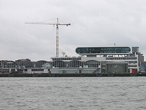
Rotterdam Cruise Terminal
Cruise ship terminal in Rotterdam
Distance: Approx. 61 meters
Latitude and longitude: 51.90583333,4.48666667
The Rotterdam Cruise Terminal is a building on the Wilhelmina Pier, Rotterdam. The Cruise Terminal served as the arrival and departure point of Holland America Line and is considered part of the city’s social and industrial heritage. The Cruise Terminal is still used by large passenger vessels that visit Rotterdam.

Kop van Zuid
Neighborhood of Rotterdam in South Holland, Netherlands
Distance: Approx. 377 meters
Latitude and longitude: 51.90694444,4.49166667
Kop van Zuid (Dutch pronunciation: [ˌkɔpfɑnˈzœyt]) is a neighborhood of Rotterdam, Netherlands, located on the south bank of the Nieuwe Maas opposite the center of town. The district is relatively young and includes the Wilhelmina Pier as well as the V bounded by the Rose Street and railway line on one side and the Rotterdam-Dordrecht Hilledijk, Hill Street and Rijnhaven on the other. The Kop van Zuid is built on old, abandoned port areas around the Binnenhaven, Entrepothaven, Spoorweghaven, Rijnhaven and the Wilhelmina Pier.

Hotel New York (Rotterdam)
Hotel in Rotterdam, Netherlands, in the former office of the Holland America Lines
Distance: Approx. 224 meters
Latitude and longitude: 51.90416667,4.48416667
Hotel New York is a hotel in Rotterdam, the Netherlands, based in the former office building of the Holland America Line (Nederlandsch Amerikaansche Stoomvaart Maatschappij, or NASM). It was used as temporary accommodation for European emigres in the late 19th and early 20th centuries: "Often, package deals were available which would combine a train ticket, hotel accommodation and passage over the oceans." When sailing from Rotterdam to New York was superseded by flying, the building became derelict in the 1980s. It was squatted in 1988.

New Orleans (Rotterdam)
44-storey, 158.3 m (519 ft) residential skyscraper in Rotterdam, Netherlands
Distance: Approx. 73 meters
Latitude and longitude: 51.90516,4.48791
New Orleans is a 44-storey, 158.3 m (519 ft) residential skyscraper in Rotterdam, Netherlands, designed by Álvaro Siza Vieira. It was the tallest residential building (and second tallest building overall) in the Netherlands, until completion of the De Zalmhaven in 2022. Consist of residential area with swimming pool, saunas and gym for residents as well as commercial area with cinema LantarenVenster.

Netherlands Photo Museum
Photography museum in Rotterdam
Distance: Approx. 199 meters
Latitude and longitude: 51.90638889,4.48916667
The Netherlands Photo Museum (Dutch: Nederlands Fotomuseum) (NFM) is a photography museum in Rotterdam, the Netherlands, that was founded in 1989. The museum collection consists of many historical, social and cultural images from the 20th and 21st century, from the Netherlands and elsewhere. It has control over more than 150 archives (three million plus images) taken by Dutch photographers.
Weather in this IP's area
overcast clouds
18 Celsius
18 Celsius
17 Celsius
19 Celsius
1014 hPa
83 %
1014 hPa
1013 hPa
10000 meters
0.51 m/s
100 %
08:12:08
18:41:50