Country:
 Belgium
Region:
City:
Latitude and Longitude:
Time Zone:
Postal Code:
IP information under different IP Channel
ip-api
Country
Region
City
ASN
Time Zone
ISP
Blacklist
Proxy
Latitude
Longitude
Postal
Route
IPinfo
Country
Region
City
ASN
Time Zone
ISP
Blacklist
Proxy
Latitude
Longitude
Postal
Route
MaxMind
Country
Region
City
ASN
Time Zone
ISP
Blacklist
Proxy
Latitude
Longitude
Postal
Route
Luminati
Country
BEASN
Time Zone
Europe/Brussels
ISP
Proximus NV
Latitude
Longitude
Postal
db-ip
Country
Region
City
ASN
Time Zone
ISP
Blacklist
Proxy
Latitude
Longitude
Postal
Route
ipdata
Country
Region
City
ASN
Time Zone
ISP
Blacklist
Proxy
Latitude
Longitude
Postal
Route
Popular places and events near this IP address

Guldensporen Stadion
Distance: Approx. 3285 meters
Latitude and longitude: 50.830432,3.248906
Guldensporen Stadion (Dutch pronunciation: [ˈɣʏldə(n)spoːrə(n) ˌstaːdijɔn]) is a multi-use stadium in Kortrijk, Belgium. It is currently used mostly for football matches and is the home ground of K.V. Kortrijk. In the summer of 2008, following the promotion of KV Kortrijk to the Belgian First Division, the capacity of the stadium was increased from 6,896 to around 9,399 The name Guldensporenstadion means "Stadium of the Golden Spurs," a reference to the medieval Battle of the Golden Spurs, fought in Kortrijk in 1302.
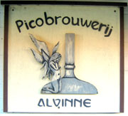
Alvinne
Brewery in Zwevegem, Belgium
Distance: Approx. 1874 meters
Latitude and longitude: 50.850234,3.229492
Alvinne is a small brewery in the hamlet of Moen near the Belgian city of Zwevegem, founded in 2002. The brewery creates a range of beers, including versions of 'traditional' Belgian styles such as strong golden ales, abbey-style beers and saison, as well as original creations that cross stylistic boundaries and beers inspired by styles from outside their home country like imperial stout. Alvinne has gained international attention.

Moorsele Airfield
Airport in Moorsele, Belgium
Distance: Approx. 4300 meters
Latitude and longitude: 50.85277778,3.14722222
Moorsele Airfield (ICAO: EBMO) is a recreational airfield located in Moorsele, a village in the municipality of Wevelgem in Belgium. It is operated by Vliegveld Moorsele VZW and was formerly operated by the Belgian Air Component. It is mainly used as a light general aviation field for ULM and parachuting activities.
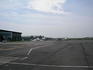
Flanders International Airport
Belgian airport
Distance: Approx. 2626 meters
Latitude and longitude: 50.81861111,3.20638889
Flanders International Airport, Flanders Airport or Kortrijk-Wevelgem International Airport (IATA: KJK, ICAO: EBKT) is an airport located in the town of Wevelgem, West Flanders in the Flemish Region of Belgium and partly also in the Bissegem section of the city of Kortrijk (2 nautical miles (3.7 km; 2.3 mi) west.

Battle of Courtrai (1918)
Battle of the Hundred Days Offensive of World War I
Distance: Approx. 4374 meters
Latitude and longitude: 50.83333333,3.26666667
The Battle of Courtrai (also known as the Second Battle of Belgium (French: 2ème Bataille de Belgique) and the Battle of Roulers (French: Bataille de Roulers)) was one of a series of offensives in northern France and southern Belgium that took place in late September and October 1918.

Bissegem
Place in West Flanders, Belgium
Distance: Approx. 2939 meters
Latitude and longitude: 50.81666667,3.21666667
Bissegem is a sub-municipality of the city of Kortrijk, Belgium. It is part of the urban area of this city. As of 2020 it had a population of 5,283.
Heule
Place in West Flanders, Belgium
Distance: Approx. 2156 meters
Latitude and longitude: 50.83333333,3.23333333
Heule is a submunicipality of the city of Kortrijk in the Belgian province of West Flanders. The first notion of this settlement date of the year 1111. Heule has a surface of 1169h and has a population of 10,503 (2009).
De Kreun
Distance: Approx. 4305 meters
Latitude and longitude: 50.825,3.2609
De Kreun is a concert hall in the Belgian city of Kortrijk. The Dutch term "Kreun" literally translates into English as "groan". It is a concert venue located in the centre of Kortrijk where most of all pop and rock concerts take place.

Buda, Kortrijk
Distance: Approx. 4277 meters
Latitude and longitude: 50.83138889,3.26444444
Buda is a historical neighbourhood in the Belgian city of Kortrijk. The neighbourhood is part of the historical old town. Since it lies between two branches of the River Leie, it is an island and is also called the 'Buda-island'.
Kuurne Heliport
Airport in Belgium
Distance: Approx. 3929 meters
Latitude and longitude: 50.85861111,3.25555556
Kuurne Heliport (ICAO: EBKU) is a heliport located near Kuurne, West Flanders, Belgium.

Battle of Courtrai (1794)
Battle in the War of the First Coalition
Distance: Approx. 4374 meters
Latitude and longitude: 50.83333333,3.26666667
The Battle of Courtrai (11 May 1794) saw a Republican French army under Jean-Charles Pichegru oppose Coalition forces commanded by François Sébastien Charles Joseph de Croix, Count of Clerfayt. The battle was fought as part of French efforts to defeat an Allied attempt to recapture Courtrai, which the French captured in the opening days of their 1794 offensive in the Low Countries. On 10 May, a French attempt to advance east toward Tournai was turned back by the Duke of York's troops in the Battle of Willems, but resulted in York himself retreating to Tournai once he realised he had underestimated the size of the French army.

Kortrijk Conservatory
Music and dance conservatory In Kortrijk, Belgium
Distance: Approx. 4304 meters
Latitude and longitude: 50.82515,3.261
Kortrijk Conservatory (Dutch: Conservatorium van Kortrijk) is a music and dance conservatory in Kortrijk, Belgium.
Weather in this IP's area
overcast clouds
12 Celsius
12 Celsius
11 Celsius
13 Celsius
1007 hPa
94 %
1007 hPa
1005 hPa
10000 meters
7.16 m/s
12.35 m/s
247 degree
99 %
07:47:52
19:25:27