217.73.141.73 - IP Lookup: Free IP Address Lookup, Postal Code Lookup, IP Location Lookup, IP ASN, Public IP
Country:
Region:
City:
Location:
Time Zone:
Postal Code:
IP information under different IP Channel
ip-api
Country
Region
City
ASN
Time Zone
ISP
Blacklist
Proxy
Latitude
Longitude
Postal
Route
Luminati
Country
Region
11
City
tirana
ASN
Time Zone
Europe/Tirane
ISP
Vodafone Albania Sh.A.
Latitude
Longitude
Postal
IPinfo
Country
Region
City
ASN
Time Zone
ISP
Blacklist
Proxy
Latitude
Longitude
Postal
Route
IP2Location
217.73.141.73Country
Region
tirane
City
tirana
Time Zone
Europe/Tirane
ISP
Language
User-Agent
Latitude
Longitude
Postal
db-ip
Country
Region
City
ASN
Time Zone
ISP
Blacklist
Proxy
Latitude
Longitude
Postal
Route
ipdata
Country
Region
City
ASN
Time Zone
ISP
Blacklist
Proxy
Latitude
Longitude
Postal
Route
Popular places and events near this IP address

Tirana
Capital city of Albania
Distance: Approx. 39 meters
Latitude and longitude: 41.32722222,19.81861111
Tirana ( tih-RAH-nə, Albanian pronunciation: [tiˈɾana]; Gheg Albanian: Tirona) is the capital and largest city of Albania. It is located in the centre of the country, enclosed by mountains and hills, with Dajti rising to the east and a slight valley to the northwest overlooking the Adriatic Sea in the distance. It is among the wettest and sunniest cities in Europe, with 2,544 hours of sun per year.

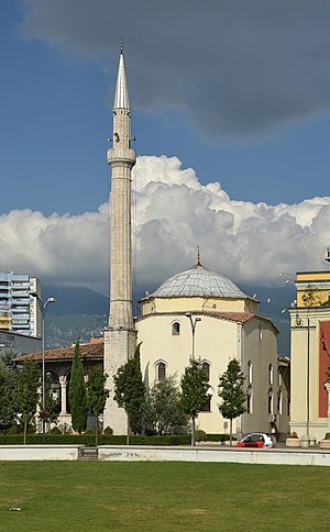
Et'hem Bey Mosque
Mosque stated in Tirana, Albania
Distance: Approx. 38 meters
Latitude and longitude: 41.32777778,19.81916667
The Haji Et'hem Bey Mosque (Albanian: Xhamia e Haxhi Et'hem Beut, Turkish: Hacı Edhem Bey Camii) is a mosque in Tirana, Albania, known for its frescoes outside and inside the portico which depict trees, waterfalls and bridges. Closed under communist rule, the mosque reopened as a house of worship in 1991. Without permission from the authorities, 10,000 people attended and the police did not interfere.

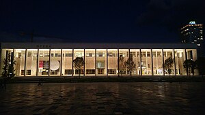
National Theatre of Opera and Ballet of Albania
Distance: Approx. 125 meters
Latitude and longitude: 41.3286,19.8192
The National Theatre of Opera and Ballet of Albania (Albanian: Teatri Kombëtar i Operas dhe Baletit - TKOB) is a theatre in Tirana, Albania. It is the largest theatre in the country and hosts music and dance performances year-round.

National Theatre (Albania)
Former theatre in Tirana, Albania
Distance: Approx. 174 meters
Latitude and longitude: 41.3265,19.8205
The National Theatre of Albania (Albanian: Teatri Kombëtar) was the main theatre in Tirana, Albania. In March 2020, the National Theatre of Albania was selected by Europa Nostra among the 7 most endangered monuments in Europe, as an exceptional example of modern Italian architecture from the 1930s and one of the most prominent cultural centers in Albania, facing impending threat of demolition. On 17 May 2020, the National Theatre building was demolished.
Palace of Culture of Tirana
Palace of Culture, Opera House in Tirana, Albania
Distance: Approx. 161 meters
Latitude and longitude: 41.32888889,19.81944444
The Palace of Culture of Tirana (Albanian: Pallati i Kulturës) was built on the Pazari i Vjeter area of Tirana by request of Enver Hoxha. For this construction, both the old bazaar and the historic mosque of Mahmud Muhsin Bey Stërmasi were destroyed under the rulership of the Albanian Labour Party in adherence to the communist country's declaration of state atheism. The Ottoman mosque had been built from 1837 to 1840 and had a tiled roof as well as a striking minaret with a sherefe.

Skanderbeg Square
Public square in Tirana, Albania
Distance: Approx. 104 meters
Latitude and longitude: 41.32833333,19.81833333
The Skanderbeg Square (Albanian: Sheshi Skënderbej) is the main plaza in the centre of Tirana, Albania. The square is named after the Albanian national hero Gjergj Kastrioti Skënderbeu. The total area is about 40,000 square metres.
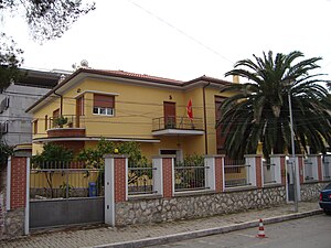
Embassy of Montenegro, Tirana
Diplomatic mission
Distance: Approx. 168 meters
Latitude and longitude: 41.32704,19.82081
The Montenegrin Embassy inTirana (Montenegrin: Ambasada Crne Gore u Tirani) is Montenegro's diplomatic mission to Albania. It is located at Rr. Jul Varibova 11.

Skanderbeg Monument
Bronze sculpture in Albania
Distance: Approx. 8 meters
Latitude and longitude: 41.3275,19.8188
The Skanderbeg Monument is a monument in the Skanderbeg Square in Tirana, Albania. It commemorates Skanderbeg (1405–1468), the national hero in Albania for resisting the Ottomans. Created by Odhise Paskali, the 11 metres (36 ft) monument was inaugurated in January 1968 on the 500th anniversary of the death of Skanderbeg.

Resurrection Cathedral, Tirana
Orthodox cathedral in Tirana, Albania
Distance: Approx. 170 meters
Latitude and longitude: 41.32638889,19.8175
The Resurrection Cathedral (Katedralja Ngjallja e Krishtit) is an Albanian Orthodox church situated in the center of Tirana, Albania. It is considered among the largest Eastern Orthodox churches in the Balkans. It was officially opened on June 24, 2012, to celebrate the 20th anniversary of the revival of the Albanian Orthodox Church and the election of Archbishop Anastasios of Albania.
Dibër Street
Street in Tirana, Albania
Distance: Approx. 221 meters
Latitude and longitude: 41.32944444,19.81944444
Dibër Street (Albanian: Rruga e Dibrës, formerly Rruga Bajram Curri) is a major street in Tirana, Albania. It runs northeast from the central Skanderbeg Square, just south of the Tirana International Hotel. The Mother Teresa Hospital (QSUT) is located on this street.

Kapllan Pasha Tomb
Historic site in Tirana, Albania
Distance: Approx. 233 meters
Latitude and longitude: 41.32777778,19.82166667
The Kapllan Pasha Tomb (Albanian: Tyrbja e Kapllan Pashës) is a Muslim Türbe built in 1817 in the center of Tirana, Albania. The government of Albania declared it a Cultural Monument of the first category in 1948. Its 8 columns are made of carved stone, placed on an octagonal-shaped stone base, and capped with octagonal shape capitals.

Museum of Secret Surveillance
Communism history museum in Tirana, Albania
Distance: Approx. 223 meters
Latitude and longitude: 41.32667,19.81647
The Museum of Secret Surveillance (Albanian: Muzeu i Përgjimeve të Sigurimit të Shtetit), also known as House of Leaves (Shtëpia me Gjethe) is a historical museum in Tirana, Albania. It opened on 23 May 2017 in the building that served as the Sigurimi's headquarters during the communist era.
Weather in this IP's area
moderate rain
6 Celsius
5 Celsius
6 Celsius
6 Celsius
1013 hPa
87 %
1013 hPa
976 hPa
10000 meters
2.57 m/s
330 degree
100 %

